Platforms: iPhone, iPad, iPod Touch, Apple iPhone OS
Categories: System Utilities, Travel & Navigation
Upload date: 21 Jun 12
Developer: Dirk Stichling
License: Freeware
Downloads: 307
myTracks is not yet another GPS tracking app, but the perfect supplement for the desktop edition of myTracks for Mac OS X. GPS tracks can be recorded with both iPhone or iPod Touch and easily synchronized with your Mac. On the Mac the tracks can be organized comfortably and linked with photos of your digital camera (Geotagging). Afterwards you can download your desktop track library including the photos onto your iPhone. Now you can take all of your tracks including your photos with you all the time.
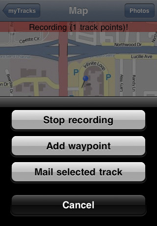
· Recording of GPS tracks with iPhone or iPod Touch
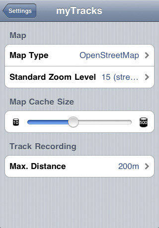
· Presentation of the tracks on maps by OpenStreetMap or Bing Maps
· The OpenStreetMap can be used offline. You don't need an active internet connection.
· Creation of waypoints
· Tracks can be sent by e-mail
· Bookmarks
· Recorded tracks can be synchronized with your Mac easily.
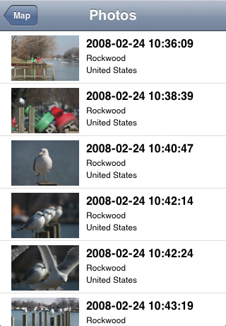
· The tracks organized on your Mac can by loaded to your iPhone. If the tracks have linked photos downscaled versions of the photos are copied to the iPhone.
· The positions of the photos are shown on the map
· Fullscreen navigator for the photos
· Photos can be sent by e-mail
What's New in This Release:
· New map implementation with seamless zooming and smooth scrolling.
What's New in 1.6.0:
· Optimized for retina display.
· New map type: "OpenStreetMap Big" with extra big fonts.
· The current speed and direction is shown.
What's New in 1.5.1:
· New Map: OpenPisteMap
· Minor improvements and bug fixes
What's New in 1.4.0:
· New first view for easier navigation
· Recovery mode for recorded tracks in case the App gets killed
· minor Bugfixe
Like it? Share with your friends!
If you got an error while installing Themes, Software or Games, please, read FAQ.
Supported operating systems:
Apple iOS 10.x (iPad), Apple iOS 10.x (iPhone), Apple iOS 11.x (iPad), Apple iOS 12.x (iPad), Apple iOS 12.x (iPhone), Apple iOS 4.0.x (iPhone), Apple iOS 4.0.x (iPod Touch), Apple iOS 4.2.x (iPad), Apple iOS 4.2.x (iPhone), Apple iOS 4.2.x (iPod Touch), Apple iOS 4.3.x (iPad), Apple iOS 4.3.x (iPhone), Apple iOS 4.3.x (iPod Touch), Apple iOS 5.0 (iPad), Apple iOS 5.0 (iPhone), Apple iOS 5.0 (iPod Touch), Apple iOS 6.0 (iPad), Apple iOS 6.0 (iPhone), Apple iOS 6.0 (iPod Touch), Apple iOS 7.0 (iPad), Apple iOS 7.0 (iPhone), Apple iOS 7.0 (iPod Touch), Apple iOS 8.x (iPad), Apple iOS 8.x (iPhone), Apple iOS 8.x (iPod Touch), Apple iOS 9.x (iPad), Apple iOS 9.x (iPhone), Apple iOS 9.x (iPod Touch), Apple iPhone OS 3.1.x, Apple iPhone OS 3.1.x (iPod Touch), Apple iPhone OS 3.2.x (iPad)
Similar Software:
NAVIGON help2park With NAVIGON help2park, you can find all the possible parking spaces in the surrounding area based on your GPS position – clearly laid out, with an address and telephone number (where available)
Sheffield (UK) Map Offline Sheffield (UK) Map Offline - This will be perfect when you are traveling and you don't have internet connection. This Offline Maps is not a replacement of Google Maps. It is used when you don't have internet connection and want to use maps
Fayetteville (AR,USA) Maps Offline Fayetteville (AR,USA) Maps Offline - This will be perfect when you are traveling and you don't have internet connection. This Offline Maps is not a replacement of Google Maps. It is used when you don't have internet connection and want to use maps
NAVIGON MobileNavigator Turkey NAVIGON MobileNavigator Turkey - With the NAVIGON MobileNavigator you can transform your iPhone into a fully functional mobile navigation system that is every bit as good as the multi-award-winning personal navigation devices from NAVIGON in terms of its user-friendliness and features
Crater Lake National Park - GPS Map Navigator Crater Lake National Park - GPS Map Navigator - Continues in the tradition of offering depth of information and functionality across expected places all over the world, exploring the map you get maximum details obtaining detailed information of each object on the map
My Local My Local - If you want to find something in the local area with a single tap, this is the application for you and it's free!
My Local dedicates to quick and accurate local search. It starts with a favorite list to which you can add your favorite local searches. With a single tap, you quickly get relevant results
Marine: Chesapeake Bay - GPS Map Navigator Marine: Chesapeake Bay - GPS Map Navigator - Continues in the tradition of offering depth of information and functionality across expected places all over the world, exploring the map you get maximum details obtaining detailed information of each object on the map
Marine: (London - Thames) - GPS Map Navigator Marine: (London - Thames) - GPS Map Navigator - FlytoMap provides complete, quick and easy to use map applications for navigation for iPhone. Continues in the tradition of offering depth of information and functionality across expected places all over the world, exploring the map you get maximum details obtaining detailed information of every object on the map
Marine : Cote d'Azur - GPS Map Navigator Marine : Cote d'Azur - GPS Map Navigator - FlytoMap provides complete, quick and easy to use map applications for navigation for iPhone. Continues in the tradition of offering depth of information and functionality across expected places all over the world, exploring the map you get maximum details obtaining detailed information of every object on the map
Virgin Islands - GPS Map Navigator Virgin Islands - GPS Map Navigator - FlytoMap provides complete, quick and easy to use map applications for navigation for iPhone. Continues in the tradition of offering depth of information and functionality across expected places all over the world, exploring the map you get maximum details obtaining detailed information of every object on the map
Other Software by developer «Dirk Stichling»:
GeoMaps GeoMaps provides a whole bunch of different maps for your iPad. Most of the maps are cached so that you can use them offline. It is even possible to download maps for a complete region for offline usage. GeoMaps is the perfect addition to the Map App already installed on your iPad

")


 Map Offline")
 Maps Offline")


 - GPS Map Navigator")


