Cabela's Recon Hunt is the first mobile navigation application built solely for hunters. With Recon Hunt, you can find hunting spots on detailed maps, track wildlife, take trophy photos and backtrack home. Recon Hunt also tracks other essentials as well: weather forecasts, sun and moon phases, trip stats and ballistics information. Our power saver technology monitors how you use the app in order to preserve battery power. Plus, Recon Hunt works in remote places without the need of data and cellular signals.
GO ANYWHERE
• Recon Hunt uses the GPS built into your iPhone to track your location with GPS satellites. No data or phone signal is needed to see your current location or to mark points.
• View unlimited topographic maps in the United States and Canada. Topo maps are 1:24K scale in the Lower 48, 1:63K in Alaska, and 1:50K in Canada.
• Consult street maps, terrain maps, and satellite photos for more info.
• Store up to 500MB of map quads on your iPhone for offline viewing and fast load times in the field.
STAY FOUND
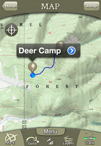
• Follow your track on seamless maps. Zoom in, zoom out. Know where you are at all times.
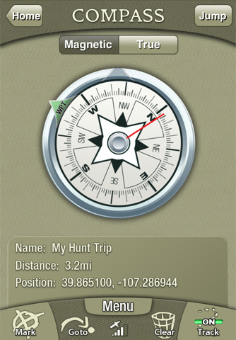
• Navigate with the digital compass. Choose between: Magnetic North and True North. (Note: Magnetic Compass only works on iPhone 3GS and 4)
• Use the Goto feature to navigate from your current location to a saved or manually entered coordinate.
COLLECT DATA
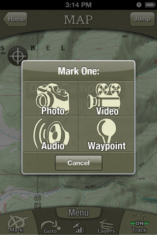
• Mark waypoints of your favorite (or secret) spots like a hunting blind, treestand, game trails or where you parked your truck.
• Record unlimited tracks. See where and how far you have traveled.
• Capture photos and videos (3GS and 4 only). The Recon Hunt app geotags your media to an exact location on a map.
• Record bugling elk, gobbling wild turkeys or other sounds with the audio recorder.
• See 15+ trip stats, including mileage, speed, elevation, direction, elevation gain/loss, and GPS position.
PLAN & PREPARE
• View Sun and Moon phases by date and location.
• Read the five-day weather forecast. See the current humidity, heat index, dew point, wind chill, wind speed and direction.
MADE FOR HUNTERS
• Get exclusive in-app deals and coupons from Cabela's.
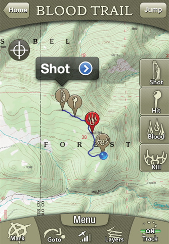
• Turn on Blood Trailing to track blood spots after the shot. Also, measure distances from shot location to hit and recovery spots.
• Disable beeps and noises in the app.
• See ballistics details and graphs for 200+ pistol and rifle cartridges.
• Save precious battery power. Recon Hunt carefully manages battery life based on how you use it.
• Enter the shooting range for your weapon and see the kill zone from your current location.
Notes: Continued use of GPS running in the background can dramatically decrease battery life. Recon Hunt is designed and optimized for the iPhone 4, 3GS, and 3G. The 1st generation models lack a GPS chip required to run the application.
What's New in This Release:
· Ballistics updates
· Enhanced Performance in Map Caching
· Minor Bug Fixes
· Additional Map Layers
· Change in Behavior of Caching with some Bing Map Layers.
What's New in 1.6:
· Ability to move waypoints in the map screen.
· Ability to change waypoint type.
· Miscellaneous bug fixes.
· Synchronization issues fixed.
What's New in 1.3.3:
· Increased download speed for map caching
· Fine-tuned drop rate calculations in ballistics
· Added Weatherby data to ballistics
· Fixed random bugs
What's New in 1.3.2:
· iOS5 updates
· Fixed ballistics bug with 9x18 Makarov bullet
· Random bug fixes
What's New in 1.3.1:
· Fixed crash that occurred after upgrading from 1.2 to 1.3.
What's New in 1.2:
· This release adds public land boundaries and hunt zones to your maps. Know your location and what land you are on at all times.
What's New in 1.1:
STORE TRIPS:
· Send your Recon Hunt trips on your phone to your private online account. Keep those trips private or check the share option to showoff trips to hunting buddies and the cabelas.com/recon community.
NEW MAP TOOLS:
· We've launched FREE mapping tools at cabelas.com/recon. Use these online tools to scout hunting lands and to preplan for your next hunt. View detailed topo, aerial, street, and terrain maps on your computer screen. Mark waypoints like your hunting blind, water sources, and fence lines. Draw routes into wild lands or on remote forest roads. And much more.
SEND TRIPS TO APP:
· Send trips you plan at cabelas.com/recon wirelessly to your Recon Hunt app. No cords or wires required.
SHARE PAST TRIPS:
· Want to share past hunts and photos? Post your stories at cabelas.com/recon. No GPS or phone app required.
YOUTUBE SUPPORT:
· Post videos directly to your YouTube account from the Recon Hunt app.
What's New in 1.0.1:
· Added ballistics info for Federal Premium Ammunition.
· Enhanced compass settings and display
· Added barometric pressure to weather reports
· Enhanced ballistics info to include current altitude and weather conditions
· Added arrival message when navigating to point
· Map track line color tweaks
· Bug fixes and performance improvements
Like it? Share with your friends!
If you got an error while installing Themes, Software or Games, please, read FAQ.
Supported operating systems:
Apple iOS 10.x (iPhone), Apple iOS 12.x (iPhone), Apple iOS 4.0.x (iPhone), Apple iOS 4.0.x (iPod Touch), Apple iOS 4.2.x (iPhone), Apple iOS 4.2.x (iPod Touch), Apple iOS 4.3.x (iPhone), Apple iOS 4.3.x (iPod Touch), Apple iOS 5.0 (iPhone), Apple iOS 5.0 (iPod Touch), Apple iOS 6.0 (iPhone), Apple iOS 6.0 (iPod Touch), Apple iOS 7.0 (iPhone), Apple iOS 7.0 (iPod Touch), Apple iOS 8.x (iPhone), Apple iOS 8.x (iPod Touch), Apple iOS 9.x (iPhone), Apple iOS 9.x (iPod Touch)
Similar Software:
Brazil - iGO primo app Brazil - iGO primo app - iGO primo app turns your iOS device into a powerful navigation system. Using the same experienced iGO Engine employed by GPS navigation devices all over the world, the app can reliably guide you to your destination in no time.
The software uses accurate offline maps which can be used anywhere
Navmii GPS Live Finland Navmii GPS Live Finland - Navmii is a powerful GPS navigation solution for iOS devices. The app features turn-by-turn directions, voice guidance, automatic rerouting, live Google and Microsoft Bing Search, and more.
Navmii uses offline maps which are stored locally on the device, so there is no need for a data connection
Nav4D Hungary Nav4D Hungary - Single intuitive menu gives the user all the information needed to begin a journey with confidence. Along the way take advantage of the automatic local and global search with rich contents.
Designed to attract everyone, the new interface concept makes usability and design a key point. Nav4D is the perfect navigation system for iPhone
CoPilot Truck North America CoPilot Truck North America - Introducing CoPilot Truck — the first voice-guided GPS Navigation iPhone app designed specifically for professional drivers of trucks and other large vehicles.
Unlike consumer navigation applications, CoPilot Truck takes into account truck-restricted and prohibited roads to provide drivers safe and reliable navigation on truck-legal roads
CoPilot Live North America CoPilot Live North America - CoPilot Live is one of the most highly acclaimed mobile GPS navigation applications available, widely recognized by the experts as the best blend of features and performance for an amazing price.
With complete, detailed street maps of the U.S
York Map Offline York Map Offline - This will be perfect when you are traveling and you don't have internet connection. This Offline Maps is not a replacement of Google Maps. It is used when you don't have internet connection and want to use maps
GeoInfo GeoInfo gives you all the useful information about your position and location in a user-friendly environment.
Swiss coordinates:
· Display the Swiss coordinates in the X-and Y-axis.
International co-ordinates:
· Display coordinates with the International Latitude and Longitude. Formatted and Decimal.
Speed:
· Display Km / h maximum speed inc
Halifax - Dartmouth (Canada) Map Offline Halifax - Dartmouth (Canada) Map Offline - This will be perfect when you are traveling and you don't have internet connection. This Offline Maps is not a replacement of Google Maps. It is used when you don't have internet connection and want to use maps
GPS Tuner (iPhone) GPS Tuner features GROUNDBREAKING off-road navigation software specifically designed for the iPhone. As opposed to traditional car navigation that plans your route based on a road network, GPS Tuner gives you the ability to navigate where the roads end
Hohe Tauern National Park - GPS Map Navigator Hohe Tauern National Park - GPS Map Navigator - FlytoMap provides complete, quick and easy to use map applications for navigation for iPhone. Continues in the tradition of offering depth of information and functionality across expected places all over the world, exploring the map you get maximum details obtaining detailed information of every object on the map
Other Software by developer «Trimble Navigation Limited»:
Geocache Navigator (Nokia) Provides hours of entertainment by combining the technology in your phone with one of the fastest-growing international hide and seek games - geocaching (also known as "GPS treasure hunt"). By using your phone's GPS and built-in Internet, Geocache Navigator creates a seamless and exciting experience
AllSport GPS (iPhone) AllSport GPS - Easier to use and delivering more value and power than ever, AllSport GPS transforms your iPhone into a full-featured workout tracker and GPS-enabled trainer for road cycling, mountain biking, running, walking, and other sports and fitness activities.
Tracking workouts on your iPhone is as easy as Start, Sweat, Stop
Trimble GPS Hunt Pro Trimble GPS Hunt Pro - Cabela's Recon Hunt is the first mobile navigation application built solely for hunters. With Recon Hunt, you can find hunting spots on detailed maps, track wildlife, take trophy photos and backtrack home. Recon Hunt also tracks other essentials as well: weather forecasts, sun and moon phases, trip stats and ballistics information
AllSport GPS FREE Track workouts--runs, rides, walks & more. Map routes. Burn calories. Reach your fitness goals faster with AllSport GPS FREE. Track workouts--runs, walks, bike rides and other sports--on a map. View 25 heart-pounding stats as you sweat: time, speed, calories, distance
AllSport GPS LE (iPhone) AllSport GPS LE - Easy to use yet delivering power and outstanding value, AllSport GPS LE - a free version of the popular AllSport GPS fitness application - transforms your iPhone into a full-featured workout tracker and GPS-enabled trainer for road cycling, mountain biking, running, walking, and other sports and fitness activities
Backpacker GPS Trails Backpacker brings the outdoors straight to the reader's doorstep, inspiring and enabling them to go more places and enjoy nature more often. The authority on active adventure, Backpacker is the world's first GPS-enabled magazine and website, and the only outdoor media whose editors and network of map contributors personally map the hiking trails they publish
Backpacker GPS Trails Lite Backpacker GPS Trails Lite - Record hiking trails, backpacking trips, and camping adventures with Backpacker GPS Trails Lite. View maps, navigate with GPS and digital compass, take photos, and backtrack to the trailhead. GPS Trails Lite works in remote places like national parks, wilderness areas, and backcountry spots without relying on data and cell signals

")


 Map Offline")
")

")
")


")

