Platforms: iPhone, iPad, iPod Touch, Apple iPhone OS
Categories: Travel & Navigation
Upload date: 26 Nov 11
Developer: Visual IT
License: Freeware
Downloads: 81
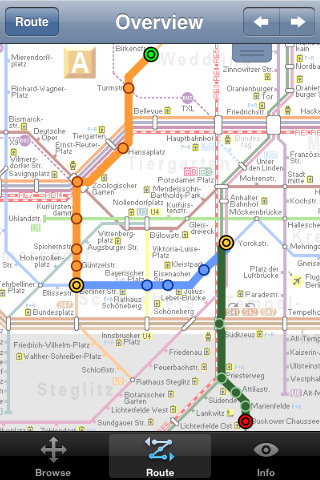
Berlin Metro 09 - The "Berlin Metro 09" application is a superb interactive map and route planner for the Berlin Metro (U-Bahn) and Suburban rail (S Bahn) systems. You can also use your inbuilt GPS (will also work with iPod Touch devices) to accurately locate and see the nearest transportation stop and distance to it. This application is one in a worldwide series of "Tube" maps from Visual IT who have been producing public transportation maps for mobile devices for many years.
SPONSORSHIP
This product is brought to you free of charge through the sponsorship of the Berlin transport authority VBB (Verkehrsverbund Berlin-Brandenburg).
MAP
Tap on the map for station information, use the inbuilt search feature or choose from a list of locations. Places of interest, museums, parks, shops, universities, theatres, etc, are also included. The route planner will automatically suggest the nearest station to any place of interest you select.
INTERNET CONNECTION
The map and routing does not require an internet connection and you will not be charged data connection fees. This also means the application runs successfully underground and on an iPod Touch. The only feature that requires an internet data connection is the “Live Info” which is optional and if used only requires a small amount of data.
ROUTING
Does not require an internet connection and will always be available to display a clear and detailed view of the city transport systems, plus list and animate the optimum route for your journey. Provides the fastest route calculations of any mobile routing application (virtually instantaneous) using actual published journey times with the ability to select the quickest route or the route with the fewest changes.
Comprehensive details of your planned route are provided, including changes, directions of travel, number of stops, predicted journey times, etc. Uniquely this application gives you “direction”, “towards” and “service frequency” information (not available on any other offline journey planner) for example “Take the U2 line (Southbound) towards Kaiserdamm for 4 stops. Service runs every 7 minutes” which is essential when finding the correct platform and connection. Also given are alternatives for each leg of the journey.
Like it? Share with your friends!
If you got an error while installing Themes, Software or Games, please, read FAQ.
Supported operating systems:
Apple iOS 10.x (iPad), Apple iOS 10.x (iPhone), Apple iOS 11.x (iPad), Apple iOS 12.x (iPad), Apple iOS 12.x (iPhone), Apple iOS 4.0.x (iPhone), Apple iOS 4.0.x (iPod Touch), Apple iOS 4.2.x (iPad), Apple iOS 4.2.x (iPhone), Apple iOS 4.2.x (iPod Touch), Apple iOS 4.3.x (iPad), Apple iOS 4.3.x (iPhone), Apple iOS 4.3.x (iPod Touch), Apple iOS 5.0 (iPad), Apple iOS 5.0 (iPhone), Apple iOS 5.0 (iPod Touch), Apple iOS 6.0 (iPad), Apple iOS 6.0 (iPhone), Apple iOS 6.0 (iPod Touch), Apple iOS 7.0 (iPad), Apple iOS 7.0 (iPhone), Apple iOS 7.0 (iPod Touch), Apple iOS 8.x (iPad), Apple iOS 8.x (iPhone), Apple iOS 8.x (iPod Touch), Apple iOS 9.x (iPad), Apple iOS 9.x (iPhone), Apple iOS 9.x (iPod Touch), Apple iPhone OS 2.x, Apple iPhone OS 2.x (iPod Touch), Apple iPhone OS 3.1.x, Apple iPhone OS 3.1.x (iPod Touch), Apple iPhone OS 3.2.x (iPad)
Similar Software:
Eat Manhattan Eat Manhattan - Eight million New Yorkers need somewhere to eat. So do the nearly 50 million tourists that visit the city every year. As a result, Manhattan is home to thousands of dining options. The only problem: one false move and lunch means a day-old hot dog rescued from a vat of murky water
Free & Frugal Paris Free & Frugal Paris - There is no need to spend your life savings to enjoy Paris. Visiting Notre Dame? Skip the overpriced tourist cafes and picnic by the Seine. Interested in Parisian history? Visit the gorgeous Musee Carnavalet - it's free
Orbitz Flights, Hotels, Cars Orbitz Flights, Hotels, Cars - Only Orbitz lets you quickly search and book flights, hotels and rental cars -- all within the Orbitz app for iPhone. You can also view your trips, check flight status and find hotels near your current location using your phone's GPS. Download the Orbitz application for free and get the power of Orbitz optimized for your iPhone today
Agoda for iPhone/iPad Agoda for iPhone/iPad - Smarter hotel booking just got smarter.
agoda.com - a world of hotels in the palm of your hand.
The agoda.com advantage. To go.
· Over 160,000 hotels worldwide
· 1,000,000+ hotel reviews every year
· Free stays with agoda
Thalys for iPhone Thalys for iPhone - Thalys is a useful app which makes trips to Paris, Brussels, Amsterdam and Cologne easier. Thalys replaces conventional tickets, allowing you to simply show your iPhone screen to the ticket collector on board the train
ATHENS, GREECE CITY ATLAS & TRAVEL SEARCH ENGINE ATHENS, GREECE CITY ATLAS & TRAVEL SEARCH ENGINE - ATLAS & TRAVEL SEARCH ENGINE
· Trip planning tool.
· GPS Companion.
· ZOOM TOUCH capability with 2-fingers.
· RE-CENTER TOUCH capability with 1-finger.
· Portrait or landscape views.
· Take a picture of your screen.
· Then print or e-mail regularly as desired
Canberra Bus Canberra Bus is a friendly timetable application that provides bus timetable for Canberra bus transport commuters. If you need an application to keep track of your favorite bus timetables throughout Canberra then this is for you!
· Access to all timetables in Canberra, Australia.
· Save and remove favorite routes at the touch of a button
Vienna Metro by Zuti Vienna Metro by Zuti - This Zuti application contains a visually unique map of Vienna's transport systems and a superb animated journey planner to help you get around the Metro (U-Bahn), Suburban Rail (S-Bahn) and Tram (Stragenbahn)
Happy Hours Happy Hours, the nation's premier happy hour guide, shows all of the food and drink specials going on near you. Click through to see a photo of the bar or restaurant, and details such as the menu, location, amenities, and what other people have to say. Our happy hour ranks are based on the community, so don't forget to vote up your favorite spots
Other Software by developer «Visual IT»:
Tube 2 Chicago (Palm OS) Tube 2 Chicago (Palm OS) - This map package for Tube 2 consists of a fully scrollable detailed map of the Chicago metro & commuter rail system.
It includes the rapid transport system of subway and elevated lines, in addition to the many commuter rail lines. The map also indicates how the Amtrak intercity routes intersect with the cities transport network
Tube Toronto (Palm OS) Tube Toronto (Palm OS) - An award winning and highly acclaimed Palm OS application that guides you around the subway system of Toronto. An essential addition to your Palm device for locals and tourists alike.
Tube's features include:
A detailed clear colour (or grey scale) map of the transport system fully scrollable.
Quick find station utility
Tube London (2009 Edition) Tube London (2009 Edition) - Tube London
The ideal map for the traveller who needs to get around London using the underground system and would like to know just exactly where they are.
The map geographically locates all the central stations, making it much more informative than the official topological map
TUBE 2 Amsterdam Pro TUBE 2 Amsterdam Pro - This map package for Tube 2 consists of a fully scrollable detailed map of the Amsterdam tram & metro system and linked street maps of central Amsterdam.
Plan journeys on the tram & metro system, list details of the quickest routes and see a superb animated display of your journey tracking around the system map
Tube 2 Boston Pro (Palm OS) Tube 2 Boston Pro (Palm OS) - This map package for Tube 2 consists of a fully scrollable detailed map of the Boston metro & commuter rail system and linked street maps of central Boston.
Plan journeys on the metro system, list details of the quickest routes and see a superb animated display of your journey tracking around the system map
Tube Hamburg (Palm OS) Tube Hamburg (Palm OS) - An award winning and highly acclaimed Palm OS application that guides you around the metro (S-Bahn / U-Bahn) system of Hamburg. An essential addition to your Palm device for locals and tourists alike.
Tube's features include:
A detailed clear colour (or grey scale) map of the transport system fully scrollable.
Quick find station utility
Tube Munich (UIQ) Tube Munich (UIQ) - An award winning and highly acclaimed application that guides you around the complex metro (S-Bahn / U-Bahn) system of Munich.
An essential addition to your P800 / P900 / P910 if if you travel in or around this city
· A detailed clear colour map of the Munich metro (S-Bahn / U-Bahn) system fully scrollable.
· Quick find station utility
Tube 2 Baltimore (UIQ) Tube 2 Baltimore (UIQ) - This map package for Tube 2 consists of a fully scrollable detailed map of the Baltimore metro & rail system.
Plan journeys on this system, list details of the quickest routes and see a superb animated display of your journey tracking around the system map
Tube Montreal (UIQ) Tube Montreal (UIQ) - Our award winning and highly acclaimed application that guides you around the metro system of Montreal is now available for your Symbian UIQ phone.
An essential addition to your P800 / P900 / P910 if you travel in or around this city.
· A detailed clear colour map of the Montreal metro system fully scrollable
Tube 2 Rome Pro (UIQ3) Tube 2 Rome Pro (UIQ3) - This map package for Tube 2 consists of a fully scrollable detailed map of the Rome metro & rail system and linked high quality street maps of central Rome.
Plan journeys on the metro system, list details of the quickest routes and see a superb animated display of your journey tracking around the system map

")


")
")
")

")
")
")
")
")
")