Platforms: iPhone, iPad, iPod Touch, Apple iPhone OS
Categories: Travel & Navigation
Upload date: 17 Jun 12
Developer: Megalith Systems
License: Freeware
Downloads: 695
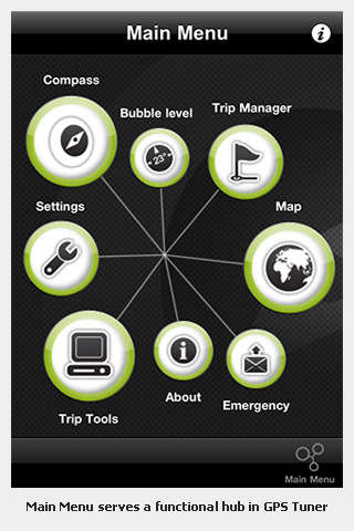
GPS Tuner Lite features GROUNDBREAKING off-road navigation software specifically designed for the iPhone. As opposed to traditional car navigation software that plans your route based on a road network, GPS Tuner gives you the ability to navigate where the roads end.
· Get your running, hiking or biking routes planned AUTOMATICALLY or draw a freeline for manual routing (available in the continental United States).
· With SmartRoute off-road route planning you can go around rough terrain and find the easiest route in the wilderness.
· Leverage online route planning for pedestrians or vehicles when an in an urban environment
· 4 different types of route planning logics
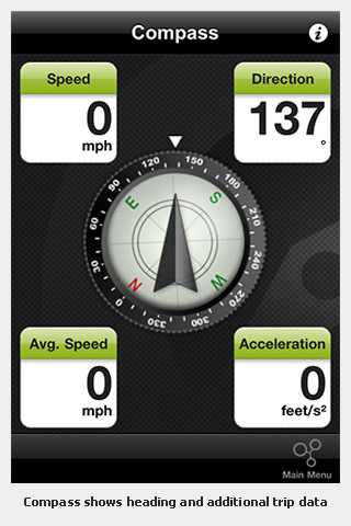
· Find your bearings and GPS position instantly and display it on a map
· Select from 8 different types of online maps from multiple providers.
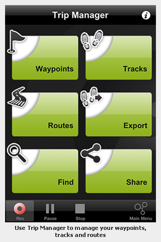
· Save and export your route with a tap of your iPhone display (GPS Tuner for iPhone offers an UNLIMITED NUMBER of routes)
· iPhone’s digital compass functionality is integrated to display real heading and target direction for more accurate positioning and heading
· Bubble level to assist in measuring slopes
· A set of 3 different speedometers with speed limit warnings
· 23 selectable trip computer tools with multiple layout options (GPS Tuner for iPhone offers 40 Trip Computer tools)
· Track recording and analyzing (GPS Tuner for iPhone offers unlimited tracks. Lite version is limited to 1 track at a time)
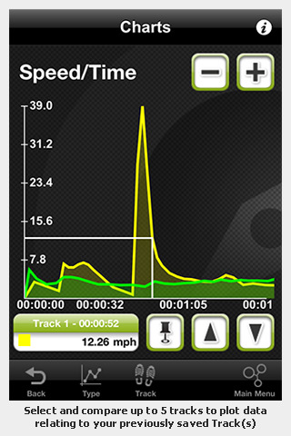
· Trip computer charts to visualize performance data
· Stats of your trip can be displayed in chart format for thorough analysis (GPS Tuner for iPhone offers multiple trip statistics)
· Email messages allow you to stay connected! You’ll never be out of sight within cellular network coverage. (GPS Tuner for iPhone offers three types of predefined Emergency and Information email templates)
· Download online maps on the fly! Lite version offers one downloaded map with a maximum of five zoom levels, while GPS Tuner for iPhone comes with unlimited downloads and zoom level options.
· Maps in GPS Tuner can be stored on your iPhone’s internal storage for fast, reliable offline access and fast map rendering!
· GPS Tuner displays your geographical location and tracks routes and waypoints in selected maps or satellite imagery.
· Share your location, details and photos directly via Facebook and send your GPS position to Twitter. Email and share .kml,.kmz,.gpx files with location and track information that can be viewed with Google Earth. Lite version handles 5 waypoints at a time while GPS Tuner for iPhone offers unlimited waypoints.
· Add photos to waypoints and display them as rich POI content
What's New in This Release:
· Fixed a compatibility issue with kml exports.
What's New in 1.0.9:
· Updated the online source for OpenCycleMap
What's New in 1.0.6:
· Fixed some issues with online functionalities accessed offline.
What's New in 1.0.3:
· Reduced memory load during map download. This should prevent possible crashes while downloading high amounts of map tiles.
Like it? Share with your friends!
If you got an error while installing Themes, Software or Games, please, read FAQ.
Supported operating systems:
Apple iOS 10.x (iPad), Apple iOS 10.x (iPhone), Apple iOS 11.x (iPad), Apple iOS 12.x (iPad), Apple iOS 12.x (iPhone), Apple iOS 4.0.x (iPhone), Apple iOS 4.0.x (iPod Touch), Apple iOS 4.2.x (iPad), Apple iOS 4.2.x (iPhone), Apple iOS 4.2.x (iPod Touch), Apple iOS 4.3.x (iPad), Apple iOS 4.3.x (iPhone), Apple iOS 4.3.x (iPod Touch), Apple iOS 5.0 (iPad), Apple iOS 5.0 (iPhone), Apple iOS 5.0 (iPod Touch), Apple iOS 6.0 (iPad), Apple iOS 6.0 (iPhone), Apple iOS 6.0 (iPod Touch), Apple iOS 7.0 (iPad), Apple iOS 7.0 (iPhone), Apple iOS 7.0 (iPod Touch), Apple iOS 8.x (iPad), Apple iOS 8.x (iPhone), Apple iOS 8.x (iPod Touch), Apple iOS 9.x (iPad), Apple iOS 9.x (iPhone), Apple iOS 9.x (iPod Touch)
Similar Software:
Los Angeles GPS Guide The only thing we do, help you to move freely as an alien, by "Offline" & "GPS"
Magellan RoadMate USA Transform your iPhone or iPod touch into an easy-to-use GPS navigator with real-time traffic alerts included!
Backpacker GPS Trails Lite Backpacker GPS Trails Lite - Record hiking trails, backpacking trips, and camping adventures with Backpacker GPS Trails Lite. View maps, navigate with GPS and digital compass, take photos, and backtrack to the trailhead. GPS Trails Lite works in remote places like national parks, wilderness areas, and backcountry spots without relying on data and cell signals
EEU Region - iGO primo app EEU Region - iGO primo app - iGO primo app turns your iOS device into a powerful navigation system. Using the same experienced iGO Engine employed by GPS navigation devices all over the world, the app can reliably guide you to your destination in no time.
The software uses accurate offline maps which can be used anywhere
Theodolite Pro Based on a centuries-old astronomical instrument, Theodolite is a cool multi-function augmented reality app for the iPhone that serves as a compass, GPS, map, zoom camera, rangefinder, and two-axis inclinometer
Nav4D Luxembourg Nav4D Luxembourg - Single intuitive menu gives the user all the information needed to begin a journey with confidence. Along the way take advantage of the automatic local and global search with rich contents.
Designed to attract everyone, the new interface concept makes usability and design a key point. Nav4D is the perfect navigation system for iPhone
Ndrive Hong Kong and Macau Ndrive Hong Kong and Macau - This app will turn your iPhone into a turn by turn voice navigation device.
WHAT YOU ARE BUYING
You are buying a lifetime license of the latest maps. There are no monthly fees or hidden charges
Hamburg Wadden Sea National Park - GPS Map Navigator Hamburg Wadden Sea National Park - GPS Map Navigator - FlytoMap provides complete, quick and easy to use map applications for navigation for iPhone. Continues in the tradition of offering depth of information and functionality across expected places all over the world, exploring the map you get maximum details obtaining detailed information of every object on the map
Great Smoky Mountains National Park - GPS Map Navigator Great Smoky Mountains National Park - GPS Map Navigator - Continues in the tradition of offering depth of information and functionality across expected places all over the world, exploring the map you get maximum details obtaining detailed information of each object on the map
My Local My Local - If you want to find something in the local area with a single tap, this is the application for you and it's free!
My Local dedicates to quick and accurate local search. It starts with a favorite list to which you can add your favorite local searches. With a single tap, you quickly get relevant results
Other Software by developer «Megalith Systems»:
GPS Tuner (iPhone) GPS Tuner features GROUNDBREAKING off-road navigation software specifically designed for the iPhone. As opposed to traditional car navigation that plans your route based on a road network, GPS Tuner gives you the ability to navigate where the roads end
Pocket PC ESP Pocket PC ESP - The ESP (Extrasensory Perception) is an ability of certain people. This ability makes possible for them to get information on people, events and objects distant both in time and in space in a way that is still unknown for science
Map Calibrator Map Calibrator - If you would like to calibrate maps on your desktop PC, use free Map Calibrator program. Map Calibrator is also useful to create map slices from a huge bitmap image file. You can convert GIF, BMP and PNG files into JPG file to use it in GPS Tuner as well
DynaInk DynaInk is a simple but revolutionary new drawing application which simulates real drawing experience on a touch screen mobile device. DynaInk (thanks to its patent pending technology) can react your drawing dynamism and can change the line width and line color according to it. The result is a rich and eye candy picture

")
")
")


")


