Platforms: iPhone, iPad, iPod Touch, Apple iPhone OS
Categories: Travel & Navigation
Upload date: 1 Sep 11
Developer: Flytomap
License: Commercial
Price: 7.99 $
Downloads: 28
iHunt - Minnesota is the best hunting map product available today on the market.
You can Navigate in real time looking your position on the map, you don't need internet connection, switch off the 3G and double your iPhone battery life.
It is a collection of the best hunting maps available for Minnesota.
- State Game Lands
- Wildlife Management Areas (WMA)
- State and National Forests
- State and National Parks
A full hunting guide that you can explore like an internet page, BUT WITHOUT ANY INTERNET CONNECTION:
- Hunting in Minnesota general information
- Where to Hunt ?
- Seasons and Limits for each hunting activity
- Laws
- Licensing (License Applications, License Types, License Fees)
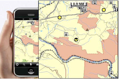
All the above fully integrated in a very detailed topographic map, using the same symbology of the best local hunting paper maps, including:
- Parks and Forests boundaries
- Natural areas boundaries
- Elevation contours (10mt step)
- roads
- trails
- WMAs
- rivers and lakes
- Mountain peaks
- Point of Interests
Imagine the above mapping data, fully available on your iPhone, without the need of any internet connection, used in conjunction with great application functionality like:
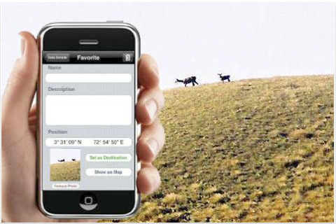
- Shoot your favorite picture and store its position on your map. Add a name and comments and retrieve it in the future
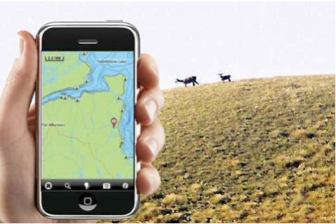
- Search for any place, including hunting areas, or your favorite spots and retrieve them on the map together with your pictures
-Track and store your path.
-Use latitudes and longitudes to go to your favorite places
- See your position on the map in real time, using your iPhone GPS and without any internet connection
- and many others
What's New in This Release:
· GPS Info Page
· Faster Names Search
What's New in 2.5.1:
· Minor bug fixed
Like it? Share with your friends!
If you got an error while installing Themes, Software or Games, please, read FAQ.
Supported operating systems:
Apple iOS 10.x (iPad), Apple iOS 10.x (iPhone), Apple iOS 11.x (iPad), Apple iOS 12.x (iPad), Apple iOS 12.x (iPhone), Apple iOS 4.0.x (iPhone), Apple iOS 4.0.x (iPod Touch), Apple iOS 4.2.x (iPad), Apple iOS 4.2.x (iPhone), Apple iOS 4.2.x (iPod Touch), Apple iOS 4.3.x (iPad), Apple iOS 4.3.x (iPhone), Apple iOS 4.3.x (iPod Touch), Apple iOS 5.0 (iPad), Apple iOS 5.0 (iPhone), Apple iOS 5.0 (iPod Touch), Apple iOS 6.0 (iPad), Apple iOS 6.0 (iPhone), Apple iOS 6.0 (iPod Touch), Apple iOS 7.0 (iPad), Apple iOS 7.0 (iPhone), Apple iOS 7.0 (iPod Touch), Apple iOS 8.x (iPad), Apple iOS 8.x (iPhone), Apple iOS 8.x (iPod Touch), Apple iOS 9.x (iPad), Apple iOS 9.x (iPhone), Apple iOS 9.x (iPod Touch), Apple iPhone OS 3.1.x, Apple iPhone OS 3.1.x (iPod Touch), Apple iPhone OS 3.2.x (iPad)
Similar Software:
Hong Kong Maps Hong Kong Maps - software that helps you download and store the travel maps and plans you need. This super-handy app lets you download publicly available maps and store them on your iPhone or iPod Touch. You can download the maps when you have fast wifi connection - and then use any time in the future without delay
Brandenburg World Travel Brandenburg World Travel - map with locate me function makes you free to move.
Background reading always accompanies you on your trip
Joshua Tree National Park - Standard Joshua Tree National Park - Standard - Continues in the tradition of offering depth of information and functionality across expected places all over the world, exploring the map you get maximum details obtaining detailed information of each object on the map
Antigua and Barbuda Street Map Antigua and Barbuda Street Map - Lets you find all streets, and many useful locations such as ATM's, parkings, museums, and many others. Remembers where you've been so you can find that parking spot where you left your rental car
Chisinau Walking Tours and Map Chisinau Walking Tours and Map - No need to hop on a tour bus or join a group; now you can explore all the best attractions on your own, at your own pace, and at a cost that is only a fraction of what you would normally pay for a guided tour
St. Petersburg Map and Walking Tours St. Petersburg Map and Walking Tours - No need to hop on a tour bus or join a group; now you can explore all the best attractions on your own, at your own pace, and at a cost that is only a fraction of what you would normally pay for a guided tour
St. Maarten Street Map St. Maarten Street Map - Lets you find all streets, and many useful locations such as ATM's, parkings, museums, and many others. Remembers where you've been so you can find that parking spot where you left your rental car
Bend, Redmond, Deschutes National Forest Map Lite Bend, Redmond, Deschutes National Forest Map Lite - Lets you find all streets, and many useful locations such as ATM's, parkings, museums, and many others. Remembers where you've been so you can find that parking spot where you left your rental car
Rome Walking Tours and Map Rome Walking Tours and Map - No need to hop on a tour bus or join a group; now you can explore all the best attractions on your own, at your own pace, and at a cost that is only a fraction of what you would normally pay for a guided tour
America Maps - Touch States America Maps - Touch States - Get a convenient and comprehensive collection of 50 USA state maps in your pocket today!
Now with maps of:
- North America
- Central America
- South America
View the 50 State maps easily by scrolling and zooming.
Take screen shots of any map for your personal use.
Touch States is great for school, work, leisure or anything else
Other Software by developer «Flytomap»:
Martha's Vineyard & Nantuket Island - GPS Map Navigator Martha's Vineyard & Nantuket Island - GPS Map Navigator - FlytoMap provides complete, quick and easy to use map applications for navigation for iPhone. Continues in the tradition of offering depth of information and functionality across expected places all over the world, exploring the map you get maximum details obtaining detailed information of every object on the map
Yellowstone National Park - Topo Yellowstone National Park - Topo - Continues in the tradition of offering depth of information and functionality across expected places all over the world, exploring the map you get maximum details obtaining detailed information of each object on the map
New River Gorge National River - GPS Map Navigator New River Gorge National River - GPS Map Navigator - Continues in the tradition of offering depth of information and functionality across expected places all over the world, exploring the map you get maximum details obtaining detailed information of each object on the map
Cuyahoga Valley National Park - Standard Cuyahoga Valley National Park - Standard - Continues in the tradition of offering depth of information and functionality across expected places all over the world, exploring the map you get maximum details obtaining detailed information of each object on the map
Mille Lacs Lake - Fishing Mille Lacs Lake - Fishing - Mille Lacs Lake is Minnesota's second largest inland lake. Relatively shallow, the large lake is one of many glacial pothole lakes in the area 100 miles west of Duluth.
Mille Lacs Lake shines especially for fishing activities
Cairngorms National Park - GPS Map Navigator Cairngorms National Park - GPS Map Navigator - FlytoMap provides complete, quick and easy to use map applications for navigation for iPhone. Continues in the tradition of offering depth of information and functionality across expected places all over the world, exploring the map you get maximum details obtaining detailed information of every object on the map
realTide realTide is able to calculate TIDE at YOUR GPS position! Flytomap's unique copyrighted algorithm is able to do it nicely!
Tidal flows are important for navigation, and significant errors in position occur if they are not accommodated.
The Tides, Currents, and Water Levels Map provides predicted times and heights of high and low waters
Marine: Cape Cod HD - GPS Map Navigator Marine: Cape Cod HD - GPS Map Navigator - FlytoMap provides complete, quick and easy to use map applications for navigation for iPad. Continues in the tradition of offering depth of information and functionality across expected places all over the world, exploring the map you get maximum details obtaining detailed information of every object on the map
Bryce Canyon National Park - GPS Map Navigator Bryce Canyon National Park - GPS Map Navigator - Continues in the tradition of offering depth of information and functionality across expected places all over the world, exploring the map you get maximum details obtaining detailed information of each object on the map
Jasmund National Park - GPS Map Navigator Jasmund National Park - flytoMap provides complete, quick and easy to use map applications for navigation for iPhone. Continues in the tradition of offering depth of information and functionality across expected places all over the world, exploring the map you get maximum details obtaining detailed information of every object on the map

")