Platforms: iPhone, iPad, iPod Touch, Apple iPhone OS
Categories: Travel & Navigation
Upload date: 10 Nov 12
Developer: Visual IT
License: Commercial
Price: 2.99 $
Downloads: 33
Paris Metro by Zuti - This Zuti application contains a visually unique map of the Paris transport system and a superb animated journey planner to help you get around the Metro, RER, SNCF, Tram, Tvm, and Vogueo services. Now revised and updated to include a larger geographic area which covers more of the outlying areas surrounding Paris. Also newly added are SNCF train services as well as the bus services RER C, RER P, Paris par le Train Navette and Tvm.
MAP
Unlike old fashioned schematic style maps this product contains a geographically accurate central area showing major streets, parks, places of interest, etc, allowing the user to easily get their bearings in the city. You can also use your inbuilt GPS to accurately locate and track yourself within the city centre and see the nearest transportation stop and distance to it. This is the only pubic transportation route planner with this ability. Tap on the map for location information, use the inbuilt search feature or choose from a list of locations. Places of interest, museums, hotels, parks, restaurant, shops, hospitals, streets, etc, are also included. The route planner will automatically suggest the nearest station to any place of interest you select. No internet connection is required for any of this functionality.
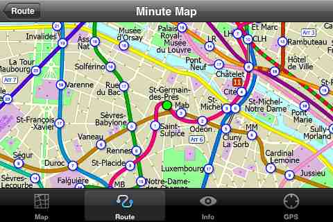
MINUTE MAP
Another great feature is the “Minute Map” option which allows you to see the travel times from a start point to all other locations on the map. This is a unique way to view the topology of a city and gauge traveling times.
ROUTING
The application does not require an internet connection and will always be available to display a clear and detailed view of the city transport systems, plus list and animate the optimum route for your journey. This product provides the fastest route calculations of any mobile routing application (virtually instantaneous) using actual published journey times with the ability to select the quickest route or the route with the least changes.
What's New in This Release:
· Completely new map and routing.
· Deep integration with inbuilt online mapping.
· Lots of new features.
· Bug fixes.
What's New in 1.3:
· Support for retina display
· New "Measure Tool"
· Bug fix for iOS 5
What's New in 1.2:
· Updated map and routes.
· Faster map loading.
· New route description text and layout.
· New "Take me home" option.
· New "Recent routes" option.
· Improved Live Info, now with departure boards.
· Various other minor updates and improvements.
Like it? Share with your friends!
If you got an error while installing Themes, Software or Games, please, read FAQ.
Supported operating systems:
Apple iOS 10.x (iPad), Apple iOS 10.x (iPhone), Apple iOS 11.x (iPad), Apple iOS 12.x (iPad), Apple iOS 12.x (iPhone), Apple iOS 4.0.x (iPhone), Apple iOS 4.0.x (iPod Touch), Apple iOS 4.2.x (iPad), Apple iOS 4.2.x (iPhone), Apple iOS 4.2.x (iPod Touch), Apple iOS 4.3.x (iPad), Apple iOS 4.3.x (iPhone), Apple iOS 4.3.x (iPod Touch), Apple iOS 5.0 (iPad), Apple iOS 5.0 (iPhone), Apple iOS 5.0 (iPod Touch), Apple iOS 6.0 (iPad), Apple iOS 6.0 (iPhone), Apple iOS 6.0 (iPod Touch), Apple iOS 7.0 (iPad), Apple iOS 7.0 (iPhone), Apple iOS 7.0 (iPod Touch), Apple iOS 8.x (iPad), Apple iOS 8.x (iPhone), Apple iOS 8.x (iPod Touch), Apple iOS 9.x (iPad), Apple iOS 9.x (iPhone), Apple iOS 9.x (iPod Touch), Apple iPhone OS 3.1.x, Apple iPhone OS 3.1.x (iPod Touch), Apple iPhone OS 3.2.x (iPad)
Similar Software:
Eat Manhattan Eat Manhattan - Eight million New Yorkers need somewhere to eat. So do the nearly 50 million tourists that visit the city every year. As a result, Manhattan is home to thousands of dining options. The only problem: one false move and lunch means a day-old hot dog rescued from a vat of murky water
Bangkok Maps Bangkok Maps - software that helps you download and store the travel maps and plans you need. This super-handy app lets you download publicly available maps and store them on your iPhone or iPod Touch. You can download the maps when you have fast wifi connection - and then use any time in the future without delay
iBART Live iBART Live From the makers of the acclaimed iBART, iBART Live is an intelligent transit application for Bay Area Rapid Transit. It is essential to all BART riders — from the occasional to the daily, the tourist to the commuter
Denver Daytrips Denver Daytrips - Visiting Denver and have a few hours, a day or more, and want to see the city, easily visit nearby towns and do some high-country exploring? Download this Denver Daytrips app, stick your iPhone in your pocket and head out. Or, grab your iPad and get going
London Tube by Zuti London Tube by Zuti - "London Tube 10" is a superb geographically based map and route planner for the London Underground, Overground, Docklands Light Railway (DLR), Croydon Tramlink and London Airport Express services. This is one in a worldwide series of Zuti maps from Visual IT who have been producing public transportation maps for mobile devices for many years
Essential Long Island Essential Long Island - Follow in the footsteps of F. Scott Fitzgerald along Long Island's fabulous Gold Coast estates. Picnic among the vineyards of the region’s burgeoning wine region. Discover Long Island’s own Rodeo Drive….and designer discount outlets. Dining, museum-hopping, mansion tours—this four-season guide has it all
Booking.com for iPhone/iPad 6.0. Booking.com for iPhone/iPad 6.0. - Booking.com allows you to quickly find and book hotels right from your iPhone, iPad or iPod touch. The app includes a database of more than 250,000 places to stay from all over the world, along with over 17 million guest reviews and more than 2.6 million hotel photos.
With Booking
Via de la Plata Via de la Plata - Spain's Vía de la Plata is the longest pilgrimage route to Compostela, stretching 1,000 kilometers from Sevilla to Santiago. This guide, through more than 75 entries and 750 photos, currently covers the stretch from Sevilla to Mérida
Washington Metro by Zuti Washington Metro by Zuti - The new Washington Metro 10 map makes it easy to travel in and around the city using the WMATA Metro, MARC and VME systems. Also included are the Potomac river taxi routes and the DC Circulator bus routes
Nashville Metro Weekend Escapes Nashville Metro Weekend Escapes - GPSmyCity.com's day trips and weekend getaways app is a powerful tool for planning a weekend away from the city. With a well researched list of getaway spots around the city you live in, you can explore natural wonders, regional history, and small town charm within a short drive from your home
Other Software by developer «Visual IT»:
London Visitors A-Z for iPad London Visitors A-Z for iPad - The London Visitors A-Z map of central London is designed especially for the tourist
Tyne & Wear Metro for iPad by Zuti Tyne & Wear Metro for iPad by Zuti - The new Tyne & Wear Metro map makes it easy to travel in and around the city using the Nexus Metro system. Unlike old fashioned schematic style maps this product contains a geographically accurate central area showing major streets, parks and places of interest etc, allowing the user to easily get their bearings
London Jubilee Walkway Guide (UIQ) London Jubilee Walkway Guide (UIQ) - Essential guide to the Jubilee Walkway, London's premier walking trail. Using full colour interactive maps designed to connect the majority of London's key attractions. It is well managed, easy to follow and provides an ideal way of getting to know London
Tube Tyne & Wear (Palm OS) Tube Tyne & Wear (Palm OS) - An award winning and highly acclaimed Palm OS application that guides you around the metro system of Tyne & Wear. An essential addition to your Palm device for locals and vistors alike.
Tube's features include:
A detailed clear colour (or grey scale) map of the transport system fully scrollable.
Quick find station utility
Tube 2 Barcelona (UIQ) Tube 2 Barcelona (UIQ) - This map package for Tube 2 consists of a fully scrollable detailed map of the Barcelona metro & rail system.
Plan journeys on the metro system, list details of the quickest routes and see a superb animated display of your journey tracking around the system map
Tube San Francisco Pro for Palm OS Tube San Francisco Pro for Palm OS - This map package for Tube 2 consists of a fully scrollable detailed map of the San Francisco metro & rail systems and linked high quality street maps of central San Francisco
Berlin Metro by Zuti Berlin Metro by Zuti - The new Berlin Metro map makes it easy to travel in and around the city using the Metro (U-Bahn) Suburban Rail (S-Bahn) and Tram (MetroTram and Straßenbahn) systems
Zoom Zoom - Do you sometimes struggle with the small text and graphics on your display?, then Zoom is the tool for you.
This small utility lets you instantly see a high quality bi-cubic zoomed area of any part of the display
Tube 2 Boston (Palm OS) Tube 2 Boston (Palm OS) - This map package for Tube 2 consists of a fully scrollable detailed map of the Boston metro & commuter rail system.
Plan journeys on this system, list details of the quickest routes and see a superb animated display of your journey tracking around the system map
Tube 2 New York Geo (UIQ) Tube 2 New York Geo (UIQ) - This superb map package for Tube 2 is the ideal map for anyone who needs to get around New York City using the MTA subway system and would like to know just exactly where they are.
The map geographically accurately locates all of Manhattans central stations, overlaid onto a street map

")


")
")
")


")
")