Platforms: iPhone, iPad, iPod Touch, Apple iPhone OS
Categories: Travel & Navigation
Upload date: 16 Nov 12
Developer: IZE, Ltd.
License: Freeware
Downloads: 98
OpenMaps - Browse the maps of OpenStreetMap (OpenStreetMap, OpenCycleMap, OpenPisteMap), download them for offline use (available via in app purchase), edit the maps (tag editing and node creation), find out where you are, search for addresses, get directions and scan the map for tweets with OpenMaps for iPhone, iPod touch and iPad.
· Pinpoint your location on the map with a tap of a button.
· Use the digital compass to rotate the onscreen map to match the direction you're facing.
· Turn off location services to reserve battery if you don't need them.
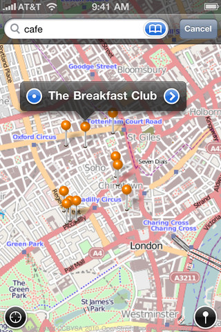
· Find out more info about places by simply tapping on their icons on the map.
· Search online for a location.
· Advanced users can add custom map types that they can browse.
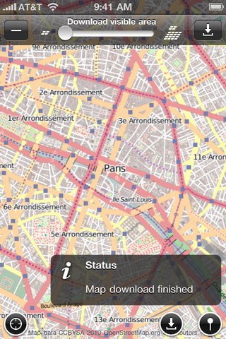
· Download maps for offline use (available via in app purchase). Note: Usage of the Download tool is strongly discouraged. You may get throttled and even banned from the map tile servers if you download abusively.
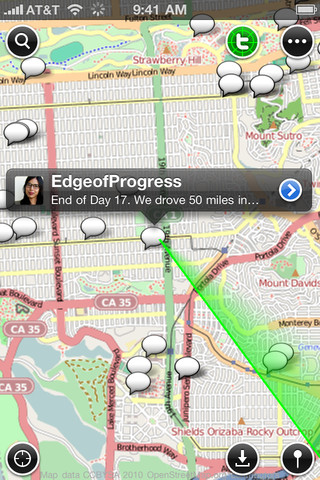
· Find out what people tweet around you or anywhere in the world by scanning the map for geotweets.
· Log in to Twitter to read your timelines and view your friends' tweets and mentions of you on the map.
· Send out checkin or comment tweets about OSM places and follow the recent Twitter conversation about them within the app.
· Do some basic edits to the map like editing tags, or even adding new places.
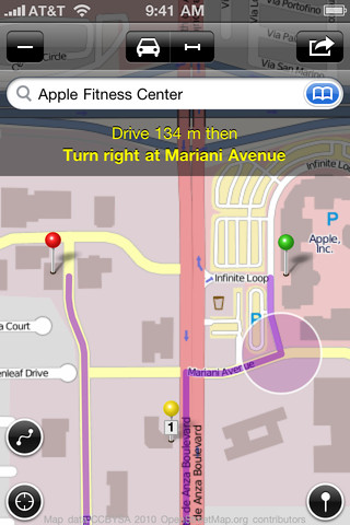
· Calculate the car, bike or pedestrian route with directions (available via in app purchase) between any two locations with the help of online route providers CloudMade and YOURS.
· Set transit points for the routes and bookmark the routes.
· Send feature requests and bug reports right within the app.
· Vote on these ideas and talk about them with other users, letting us know what your favorite ones are.
What's New in This Release:
· Updated for iOS 6 and iPhone 5.
· Better search results.
What's New in 4.6.3:
· Fixes blue dot visibility issue.
What's New in 4.6:
· Updated for iOS 5 and for iPad with retina graphics.
· Fixes Locate Tool bug.
· Fixes OSM login bug.
· Fixes landscape map layout bug.
· Fixes pin address update bug.
· Fixes 3 finger swipe up/down to change map bug.
· Fixes some OSM element refresh related crashes.
· Fixes for other minor things.
Like it? Share with your friends!
If you got an error while installing Themes, Software or Games, please, read FAQ.
Supported operating systems:
Apple iOS 10.x (iPad), Apple iOS 10.x (iPhone), Apple iOS 11.x (iPad), Apple iOS 12.x (iPad), Apple iOS 12.x (iPhone), Apple iOS 4.0.x (iPhone), Apple iOS 4.0.x (iPod Touch), Apple iOS 4.2.x (iPad), Apple iOS 4.2.x (iPhone), Apple iOS 4.2.x (iPod Touch), Apple iOS 4.3.x (iPad), Apple iOS 4.3.x (iPhone), Apple iOS 4.3.x (iPod Touch), Apple iOS 5.0 (iPad), Apple iOS 5.0 (iPhone), Apple iOS 5.0 (iPod Touch), Apple iOS 6.0 (iPad), Apple iOS 6.0 (iPhone), Apple iOS 6.0 (iPod Touch), Apple iOS 7.0 (iPad), Apple iOS 7.0 (iPhone), Apple iOS 7.0 (iPod Touch), Apple iOS 8.x (iPad), Apple iOS 8.x (iPhone), Apple iOS 8.x (iPod Touch), Apple iOS 9.x (iPad), Apple iOS 9.x (iPhone), Apple iOS 9.x (iPod Touch)
Similar Software:
Munich Map Offline Munich Map Offline - This will be perfect when you are traveling and you don't have internet connection. This Offline Maps is not a replacement of Google Maps. It is used when you don't have internet connection and want to use maps
Berchtesgaden National Park - GPS Map Navigator Berchtesgaden National Park - GPS Map Navigator - FlytoMap provides complete, quick and easy to use map applications for navigation for iPhone. Continues in the tradition of offering depth of information and functionality across expected places all over the world, exploring the map you get maximum details obtaining detailed information of every object on the map
Nav4D Oman Nav4D Oman - Single intuitive menu gives the user all the information needed to begin a journey with confidence. Along the way take advantage of the automatic local and global search with rich contents.
Designed to attract everyone, the new interface concept makes usability and design a key point. Nav4D is the perfect navigation system for iPhone
Cinque Terre National Park - GPS Map Navigator Cinque Terre National Park - GPS Map Navigator - FlytoMap provides complete, quick and easy to use map applications for navigation for iPhone. Continues in the tradition of offering depth of information and functionality across expected places all over the world, exploring the map you get maximum details obtaining detailed information of every object on the map
NAVIGON MobileNavigator Italy NAVIGON MobileNavigator Italy - With the NAVIGON MobileNavigator you can transform your iPhone into a fully functional mobile navigation system that is every bit as good as the multi-award-winning personal navigation devices from NAVIGON in terms of its user-friendliness and features
Garmin U.S.A. Garmin U.S.A. - Download Garmin StreetPilot Onboard U.S.A. and give your iPhone the best in GPS navigation...even when you don’t have cell coverage. Maps reside on your device, so you can look up addresses and millions of points-of-interest such as gas stations, restaurants and ATMs without needing wireless coverage
Herbert Hoover National Historic Site - GPS Map Navigator Herbert Hoover National Historic Site - GPS Map Navigator - Continues in the tradition of offering depth of information and functionality across expected places all over the world, exploring the map you get maximum details obtaining detailed information of each object on the map
Bryce Canyon National Park - GPS Map Navigator Bryce Canyon National Park - GPS Map Navigator - Continues in the tradition of offering depth of information and functionality across expected places all over the world, exploring the map you get maximum details obtaining detailed information of each object on the map
Nav4D Portugal Nav4D Portugal - Single intuitive menu gives the user all the information needed to begin a journey with confidence. Along the way take advantage of the automatic local and global search with rich contents.
Designed to attract everyone, the new interface concept makes usability and design a key point. Nav4D is the perfect navigation system for iPhone
Cape Town Map Offline Cape Town Map Offline - This will be perfect when you are traveling and you don't have internet connection. This Offline Maps is not a replacement of Google Maps. It is used when you don't have internet connection and want to use maps
Other Software by developer «IZE, Ltd.»:
OpenMaps Pro OpenMaps Pro - Browse the maps of OpenStreetMap (OpenStreetMap, OpenCycleMap, OpenPisteMap), download them for offline use, edit the maps (tag editing and node creation), find out where you are, search for addresses, get directions and scan the map for tweets with OpenMaps for iPhone, iPod touch and iPad.
· Pinpoint your location on the map with a tap of a button
Locate: Real-time Location Sharing for Facebook Locate: Real-time Location Sharing for Facebook - Locate allows you to easily locate your friends and family from your iPhone, iPad, or iPod touch. Install this application on your iOS device and sign in with your Facebook account. Invite your friends from Facebook to use this app by sending them an app request
Maps+ Maps+ - Browse Google's maps, find out where you are, search the map, get directions with route alternatives, use location-based alarms, record and edit GPS tracks, scan the map for tweets and export & import your bookmarks with Maps+, the map application with a plus for iPhone, iPod touch and iPad

")