Platforms: iPhone, iPad, iPod Touch, Apple iPhone OS
Categories: Travel & Navigation
Upload date: 12 Jul 13
Developer: Kaart Data LLC
License: Commercial
Price: 19.99 $
Downloads: 123
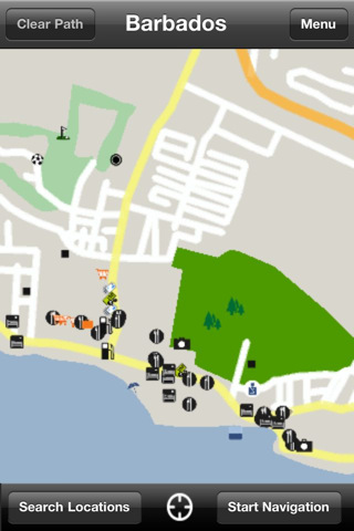
Barbados GPS Map is a navigation App for the country of Barbados. All application features and map data is stored within your iPhone, allowing you to use the app freely without the worry of expensive data charges. Fast, simple user interface with detailed map data allows you to navigate throughout Barbados using your iPhone.
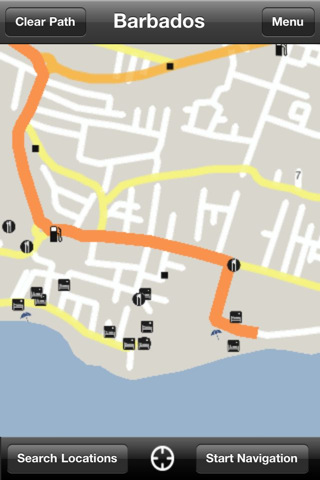
· Navigation from current position to destination
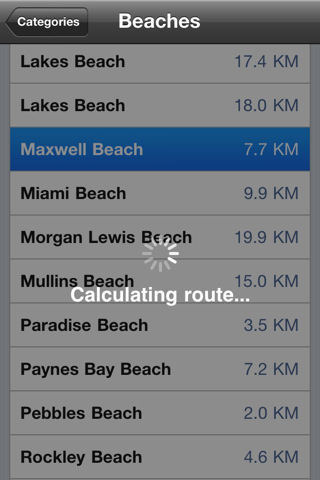
· Thousands of searchable businesses and Points of Interest
· Fastest and shortest route calculation
· Automatic route recalculation
· Custom location saving and searching
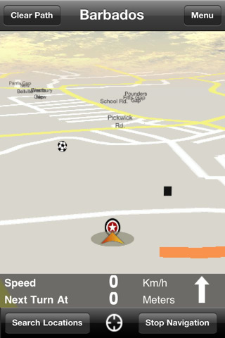
· 2D and 3D navigation views
· Distance to next turn
· Turn arrow for easier navigation
· Current speed
· Smooth panning, pinch zoom, and increased detail with zoom
What's New in This Release:
· Added and fixed POI locations in Holetown
· Added POI details (Phone, Email, Websites, etc)
· Added building footprints throughout Barbados
What's New in 4.5.0:
· iPhone 5 compatible
· French language supported
· Bug fixes and memory improvements
What's New in 4.3.6:
· Points of Interest details displayed (Address, Phone, Website, Email, Etc.)
· Spanish language supported
· Improved tracking of location while driving
· Updated road labeling and map drawing
· Bug fixes and memory improvements
· Updated map data
What's New in 4.2.5:
· Updated map data and points-of-interest
· Improved tracking of location while driving
· Improved updating of route while driving
· Updated road labeling and map drawing
· Global point-of-interest search. Search for points-of-interest without having to enter a point-of-interest category first.
· Support for driving instructions in Metric and Imperial distance units
· Bug fixes and memory improvements
What's New in 4.1.17:
· Backlight stays on while navigating
· Various bug fixes
· Performance and stability improvements
· Updated map data including roads, points of interest and other geographic details
· Automatic route recalculation
· Routing preference (Fastest vs Shortest) saved between runs of app
· Saved Recent POI Searches
· Full Screen iPad Compatibility
What's New in 4.0:
· Updated map rendering to improve stability and performance.
· Updated graphics and user interface for easier navigation.
· Updated map data including roads, points of interest and other geographic detail.
· Ability to navigate to both points of interest and roads
What's New in 3.0:
· Updated and improved map navigation
Like it? Share with your friends!
If you got an error while installing Themes, Software or Games, please, read FAQ.
Supported operating systems:
Apple iOS 10.x (iPad), Apple iOS 10.x (iPhone), Apple iOS 11.x (iPad), Apple iOS 12.x (iPad), Apple iOS 12.x (iPhone), Apple iOS 4.0.x (iPhone), Apple iOS 4.0.x (iPod Touch), Apple iOS 4.2.x (iPad), Apple iOS 4.2.x (iPhone), Apple iOS 4.2.x (iPod Touch), Apple iOS 4.3.x (iPad), Apple iOS 4.3.x (iPhone), Apple iOS 4.3.x (iPod Touch), Apple iOS 5.0 (iPad), Apple iOS 5.0 (iPhone), Apple iOS 5.0 (iPod Touch), Apple iOS 6.0 (iPad), Apple iOS 6.0 (iPhone), Apple iOS 6.0 (iPod Touch), Apple iOS 7.0 (iPad), Apple iOS 7.0 (iPhone), Apple iOS 7.0 (iPod Touch), Apple iOS 8.x (iPad), Apple iOS 8.x (iPhone), Apple iOS 8.x (iPod Touch), Apple iOS 9.x (iPad), Apple iOS 9.x (iPhone), Apple iOS 9.x (iPod Touch), Apple iPhone OS 3.1.x, Apple iPhone OS 3.1.x (iPod Touch), Apple iPhone OS 3.2.x (iPad)
Similar Software:
Manchester Map and Walking Tours Manchester Map and Walking Tours - This Lite version of the walking tours application comes with a detailed and fully functional city map to assist you explore the city and locate sights. City map functions in this app include: street name and business (restaurants, cafes, etc
Portland Map Offline Portland Map Offline - This will be perfect when you are traveling and you don't have internet connection. This Offline Maps is not a replacement of Google Maps. It is used when you don't have internet connection and want to use maps
Stockholm Offline Street Map Stockholm Offline Street Map - You don't need to have internet connection for this to work as the map is stored on your iPhone or iPod Touch. Ideal for saving roaming charges or having to find the local wifi to access the built-in map application.
What's New in This Release:
· iOS 5 compatibility changes.
· Further bug fixes and improvements
New York City ( NYC ) Maps Offline New York City ( NYC ) Maps Offline - This will be perfect when you are traveling and you don't have internet connection. This Offline Maps is not a replacement of Google Maps. It is used when you don't have internet connection and want to use maps
FlyToMap GPS - All in One FlyToMap GPS - All in One - FlytoMap provides complete, quick and easy to use map applications for navigation for iPhone. Continues in the tradition of offering depth of information and functionality across expected places all over the world, exploring the map you get maximum details obtaining detailed information of every object on the map
Lake Winnebago - Fishing Lake Winnebago - Fishing - Lake Winnebago is the largest, natural inland lake in the United States having 137,708 acres coverage. It is very shallow with an average depth of 15.5 - 21 feet.
For fishing lovers Lake Winnebago is one of the more heavily fished lakes in Wisconsin
Bath Street Map Bath Street Map - Lets you find all streets, and many useful locations such as ATM's, parkings, museums, and many others. Remembers where you've been so you can find that parking spot where you left your rental car. To make sure your phone doesn't use any expensive data on your trip, go to Settings, then General, tap on Network, and slide the Data Roaming to "off"
Split Walking Tours and Map Split Walking Tours and Map - No need to hop on a tour bus or join a group; now you can explore all the best attractions on your own, at your own pace, and at a cost that is only a fraction of what you would normally pay for a guided tour
Bakersfield Street Map Bakersfield Street Map - Lets you find all streets, and many useful locations such as ATM's, parkings, museums, and many others. Remembers where you've been so you can find that parking spot where you left your rental car
San Diego Street Map San Diego Street Map - Lets you find all streets, and many useful locations such as ATM's, parkings, museums, and many others. Remembers where you've been so you can find that parking spot where you left your rental car
Other Software by developer «Kaart Data LLC»:
Costa Rica GPS Map Costa Rica GPS Map is a navigation App for the country of Costa Rica. All application features and map data is stored within your iPhone, allowing you to use the app freely without the worry of expensive data charges. Fast, simple user interface with detailed map data allows you to navigate throughout Costa Rica using your iPhone
Guatemala GPS Map Guatemala GPS Map is a navigation App for the country of Guatemala. All application features and map data is stored within your iPhone, allowing you to use the app freely without the worry of expensive data charges. Fast, simple user interface with detailed map data allows you to navigate throughout Guatemala using your iPhone
Panama GPS Map Panama GPS Map is a navigation App for the country of Panama. All application features and map data is stored within your iPhone, allowing you to use the app freely without the worry of expensive data charges. Fast, simple user interface with detailed map data allows you to navigate throughout Panama using your iPhone

")


 Maps Offline")


