Backpacker brings the outdoors straight to the reader's doorstep, inspiring and enabling them to go more places and enjoy nature more often. The authority on active adventure, Backpacker is the world's first GPS-enabled magazine and website, and the only outdoor media whose editors and network of map contributors personally map the hiking trails they publish.
Backpacker’s GPS Trails iPhone app doubles as a portable trip database and personal navigation device for your outdoor lifestyle: hiking, backpacking, mountain biking, trail running, mountaineering, or for just basic trail navigation.
Note: Backpacker GPS Trails is designed and optimized for the iPhone 3GS and 3G. The 1st generation models lack a GPS chip required to run the application. It also does not work on the iPod touch or iPad.
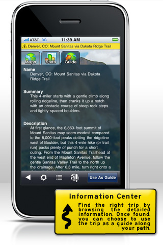
· Locate trips: Search by name or park, or select from trails near your current location—more than 3,500 Backpacker-endorsed adventures across North America.
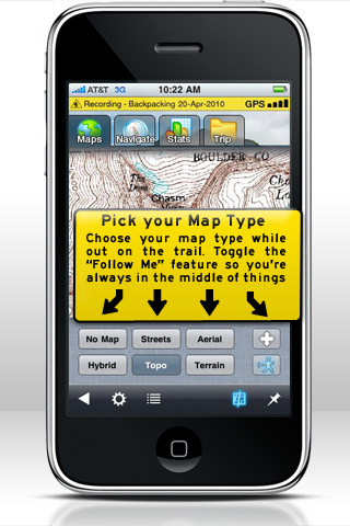
· Research trips: View fact-checked trail reports, complete with turn-by-turn directions, photos, and five map-viewing options. Use our trips to guide you on the trail.
· Plan trips: Draw routes with our free web-based map software (backpacker.com/postatrip), then send them wirelessly to your iPhone.
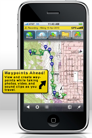
· Save and share your trip: Record unlimited tracks and points as you hike; on the way home, post them to backpacker.com wirelessly—no cord or experience needed.
· Geotag your photos, videos, and sound clips: Save coordinates with every image and see their exact location on a map.
· Turn your phone into a GPS: Navigate via precise satellite signals in and out of cell network.
· Save maps: Cache up to 500MB of topos for backcountry viewing.
· View stats: Calculate calories, speed, and distance.
· Upload GPS files: Load your own .gpx files (the standard file format for exchanging GPS files) at backpacker.com/postatrip and wirelessly send them to our GPS Trails app.
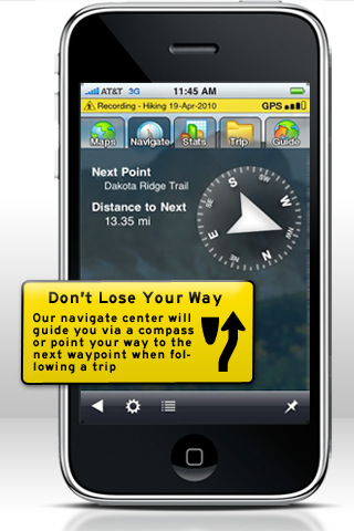
· Navigate on the trail: Our app integrates the iPhone’s built-in compass, so you can follow bearings or go to waypoints on the trail.
· Listen to music: Access your iTunes music while hiking, biking, running, or walking.
· Pick your coordinates: Choose lat/long or UTM and WGS 84 or NAD 27 then use GPS Trails for advanced navigation with traditional paper maps.
· Stay connected: Receive live app updates on new trails and navigation tips from Backpacker editors and contributors.
What's New in This Release:
· "Auto" update distance option added to save battery life while tracking; Only if support by the GPS chip.
· GPS now turns off automatically when not needed to save more battery life.
· Ability to import Trimble Outdoors Trip GPX through the iTunes File Sharing
· Ability to export Trip's GPX with media.
· Ability to archive trips to save storage space.
· Now you can share trips to Twitter.
· Stability and Improvements.
What's New in 5.6:
· Ability to purchase Mega Offline Maps.
· Track accuracy fixed in map screen.
· Miscellaneous bug fixes.
What's New in 5.3.1:
· Minor Enhancements to Messaging
· Minor Bug Fixes
· Additional Map Layers
· Change in Behavior of Caching with some Bing Map Layers.
What's New in 5.1:
· Better Map Caching
· Fixed Viewing of Trip Bundles
· Added pages to Pro Trip lists
· Repaired of some Trip Sync bugs
· Added Stats to Trip Summary screen
· Miscellaneous bug fixes & improvements
· Save your high-resolution videos to YouTube.
· View elevation and speed charts as you hike.
· Edit GPS coordinates of any waypoint collected.
· Minor bug fixes
Like it? Share with your friends!
If you got an error while installing Themes, Software or Games, please, read FAQ.
Supported operating systems:
Apple iOS 10.x (iPhone), Apple iOS 12.x (iPhone), Apple iOS 4.0.x (iPhone), Apple iOS 4.2.x (iPhone), Apple iOS 4.3.x (iPhone), Apple iOS 5.0 (iPhone), Apple iOS 6.0 (iPhone), Apple iOS 7.0 (iPhone), Apple iOS 8.x (iPhone), Apple iOS 9.x (iPhone), Apple iPhone OS 3.1.x
Similar Software:
Ndrive Mexico Ndrive Mexico - This app will turn your iPhone into a turn by turn voice navigation device.
WHAT YOU ARE BUYING
You are buying a lifetime license of the latest maps. There are no monthly fees or hidden charges.
No data plan is needed to run NDrive software and even when your phone is in roaming, your GPS Navigation from NDrive will run smoothly and uninterupted
Sygic Europe: GPS Navigation Sygic Europe: GPS Navigation - Sygic is a premium turn-by-turn GPS navigation application. Sygic is packed with valuable content: TomTom maps with 3D view of cities and landscape that are updated for free, travel guides, and thousands of POIs in comprehensive categories
Helsinki Map Offline Helsinki Map Offline - This will be perfect when you are traveling and you don't have internet connection. This Offline Maps is not a replacement of Google Maps. It is used when you don't have internet connection and want to use maps
Navfree GPS Live Norway Navfree GPS Live Norway - Navfree is a free GPS navigation solution for iOS devices. The app uses OpenStreetMap data, created and updated by thousands of users from all over the world.
The maps are stored locally on the device, so there is no need for a data connection
Navitel Navigator (Turkey) for iPhone/iPad Navitel Navigator (Turkey) for iPhone/iPad - Navitel Navigator is a GPS travel assistant for iPhone, iPad and iPod touch. The app turns your phone into a personal navigation system
Terrapad Pro Terrapad Pro gives you the flexibility to enter, query, modify and export your geographic data, all from within your iPad, iPhone or iPod Touch. Driven by a powerful database engine, a unique and simple user interface, and flexible extensions, Terrapad can meet your most demanding needs.
Simple, yet powerful
GPSMinder GPSMinder allows you to create reminders for yourself based on GPS locations and schedules. GPSMinder also takes advantage of some advanced features in iOS 4.0 to lower battery consumption while the application is in the background
Auckland Maps Offline Auckland Maps Offline - This will be perfect when you are traveling and you don't have internet connection. This Offline Maps is not a replacement of Google Maps. It is used when you don't have internet connection and want to use maps
Cape Coral - Fort Myers - Naples (FL, USA) Maps Offline Cape Coral - Fort Myers - Naples (FL, USA) Maps Offline - This will be perfect when you are traveling and you don't have internet connection. This Offline Maps is not a replacement of Google Maps. It is used when you don't have internet connection and want to use maps
CoPilot Live Premium France (iPhone) CoPilot Live Premium France (iPhone) - CoPilot Live Premium is the essential voice-guided sat navigation app to get you where you need to go, by the way that suits you best.
Detailed street maps of France are stored on-board your iPhone so you don’t need to rely on your mobile connection for navigation or worry about losing directions in coverage dead spots
Other Software by developer «Trimble Navigation Limited»:
AllSport GPS LE (iPhone) AllSport GPS LE - Easy to use yet delivering power and outstanding value, AllSport GPS LE - a free version of the popular AllSport GPS fitness application - transforms your iPhone into a full-featured workout tracker and GPS-enabled trainer for road cycling, mountain biking, running, walking, and other sports and fitness activities
Backpacker GPS Trails Lite Backpacker GPS Trails Lite - Record hiking trails, backpacking trips, and camping adventures with Backpacker GPS Trails Lite. View maps, navigate with GPS and digital compass, take photos, and backtrack to the trailhead. GPS Trails Lite works in remote places like national parks, wilderness areas, and backcountry spots without relying on data and cell signals
Geocache Navigator (Nokia) Provides hours of entertainment by combining the technology in your phone with one of the fastest-growing international hide and seek games - geocaching (also known as "GPS treasure hunt"). By using your phone's GPS and built-in Internet, Geocache Navigator creates a seamless and exciting experience
AllSport GPS FREE Track workouts--runs, rides, walks & more. Map routes. Burn calories. Reach your fitness goals faster with AllSport GPS FREE. Track workouts--runs, walks, bike rides and other sports--on a map. View 25 heart-pounding stats as you sweat: time, speed, calories, distance
Cabela's Recon Hunt Cabela's Recon Hunt is the first mobile navigation application built solely for hunters. With Recon Hunt, you can find hunting spots on detailed maps, track wildlife, take trophy photos and backtrack home. Recon Hunt also tracks other essentials as well: weather forecasts, sun and moon phases, trip stats and ballistics information
Trimble GPS Hunt Pro Trimble GPS Hunt Pro - Cabela's Recon Hunt is the first mobile navigation application built solely for hunters. With Recon Hunt, you can find hunting spots on detailed maps, track wildlife, take trophy photos and backtrack home. Recon Hunt also tracks other essentials as well: weather forecasts, sun and moon phases, trip stats and ballistics information
AllSport GPS (iPhone) AllSport GPS - Easier to use and delivering more value and power than ever, AllSport GPS transforms your iPhone into a full-featured workout tracker and GPS-enabled trainer for road cycling, mountain biking, running, walking, and other sports and fitness activities.
Tracking workouts on your iPhone is as easy as Start, Sweat, Stop

")


 for iPhone/iPad")


 Maps Offline")
")
")

")


")