Platforms: iPhone, iPad, iPod Touch, Apple iPhone OS
Categories: Travel & Navigation
Upload date: 5 Oct 13
Developer: CompeGPS
License: Commercial
Price: 64.99 $
Downloads: 87
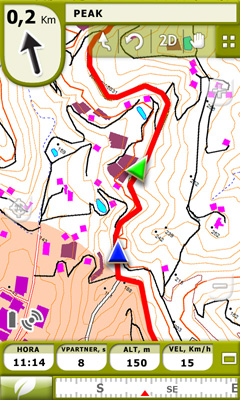
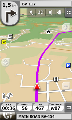
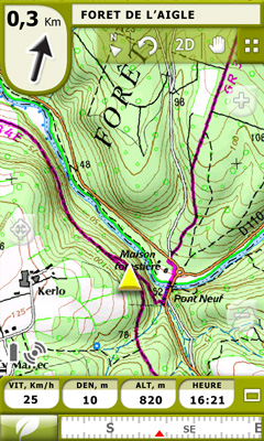
TwoNav for iPhone/iPad - A dual navigation system (On-Road/Off-Road) to perform most of your outdoor activities (hiking, biking, skiing, geocaching, ...). TwoNav can also guide you when driving. A single solution for all your orientation needs.
Load maps, tracks, routes and waypoints and get ready for your trip! - Save your performances by recording them as tracks (performance’s information is being controlled by more than 60 on-screen stats).
E-Roadbooks, data field alarms, Virtual Coach, Man Over board...It doesn’t matter which is your activity, TwoNav will cover all your needs!
What's New in This Release:
· New 'Triplog' control buttons
· New 'Tracklog' options
· Pop up alarm every kilometer or hour
· New map shop
· Mosaic maps on sale at TwoNav shop
· Update speedcams in one click
· Better protection against aberrant points
· List of elements: Animation effect
· Minor changes
· Solved bugs
What's New in 2.6.4:
GENERAL NEW FEATURES:
· Compatibility with the new map version France Geoportail.
· 'Amigos' function: Possibility to see other user's avatar if 'my Facebook image' is established by default.
SOLVED BUGS:
· Urban map 'Canada 12Q1' can be properly opened.
· Application hangs when user is editing a property in a list of elements have been solved.
· Fatal errors when joining legs of a track have been solved.
· Application hangs when launching the application under certain circumstances have been solved.
· 'AutoZoom' function works properly in iPhone 4.
· Possibility to edit texts even when the editable field is below the keyboard.
· No application hangs occur if user starts using 'Amigos' function without internet connection.
What's New in 2.6.3:
· Add Push notifications for Amigos platform
What's New in 2.6.2:
Solved bugs:
· Not loading default maps at first start of application in some cases
· Margin for graph axis is too big
· Track deleted if renamed while triplog stopped
· Infocurrent not refreshed when when changing from Off-Road to On-Road
· Problem in POI folder causing undesired load of waypoints files
What's New in 2.6:
· 'Amigos' function: location-aware function developed by CompeGPS allowing you to view the current location of your contacts on the map in real time (and viceversa) and chat with them.
· Download tracks from most relevant providers: The section 'Internet content' ('Main Menu > Data') contains data available not in computer nor in connected devices but in serveral on-line providers like Everytrail or GPSies.
· Share your tracks: Opening context menu on a track you can select 'Share > myTwoNav' so a nice 'track report page' will be available to be shared on-line on facebook, twitter or other social networks. You can manage all your uploaded tracks from myTwoNav.com
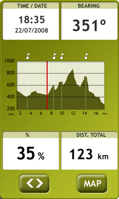
· Graph representations have been totally improved for a much detailed analysis (tracks, routes, roadbooks,...).
· Tracks' list can be sorted by accumulated climb, distance, duration or mean speed ('sort by' function available in tracks context menu).
· Data fields listed by categories
· Predefined alarms can be displayed using vibratory warnings ('Menu > Settings > Navigation > Alarms').
· At 'Settings > Display > Geocaching', the user will be able to hide geocaches that have been labeled as 'found geocache'. These geocaches will not appear on the map, thus avoiding to see geocaches that were previously found.
· Several bugs solved
What's New in 2.5.3:
· Solved bug on iOS 5.1: Application crashes when minimized
What's New in 2.5.2:
· Solved bug on ARMV6 devices (program doesn't start on iPhone 3G)
· Solved bug saving tracklog after updating the software version
· Solved bug showing the GPS position with delay when bearing is using electronic compass
What's New in 2.5.1:
· Solved bug on flat 3D
· Solved bug with speedcams (delay on position depending on speedcam density)
What's New in 2.5:
GENERAL NEW FEATURES:
· New 'TripLog' command: Record / Pause / Stop track recording.
· Waypoints and Tracks: Show more information on the list of elements.
· Calorie count tools data fields.
· New data field: City.
· New data fields: GPS precision.
· Configurable calculation of estimated time.
· Delete a specific sub-element of a *.GPX file.
· Possibility to set several predefined data folders.
· Minimize GPS by pressing 'Home' button.
· 'Trackback' function.
· Track subdivision in legs.
· Show/Hide the current recorded track in the list of tracks.
· Sort tracks.
· New track properties: Track title, Rating, Cyclability, Circular, Terrain...
· Record track also in *.GPX format.
· Anchor: Fix position as 'virtual position'.
· New 'auto-map' possibilities.
· Autozoom also available in Off-Road mode.
· Reliefs in 2D maps.
· Sea level representation.
· Open the best map from the contextual menu.
· Live roadbook creation.
MINOR CHANGES:
· 'Automap' function is opening maps according to the current position on the screen instead of the actual location of the user.
· Visibility of track direction arrows has been improved for a much easier perception ('Main Menu > Settings > Navigation > Tracks')
· Vertical speed units have been changed to m/min.
· The list of waypoints automatically reordered by proximity while the user is moving.
· 'Historic' ('Main Menu > Navigate') also shows tracks and routes recently performed.
· Different sound is displayed for 'next event' function and 'radar' alarm avoiding misconceptions.
· Radar visual alert image has been updated.
· HTML-formatted texts allow the usage of italic characters (for waypoints, roadbooks, geocaching, routes as well as attached designed documents).
· In case speed is lower than defined 'Minimum moving speed', instead of '0 km/h', 'Stopped' is displayed in the data field.
· Properties which appear when 'Mark & Edit Waypoint/Roadbook point' is pressed also include 'Associated file'.
· Instead of showing '****' for elements without a file name (waypoints or roadbook points), no text is presented as name of the file.
· Waypoints are sorted by name with no differentiation between waypoint starting with a capital letter and non-capitalized titles.
· Track properties 'difficulty' and 'activity' are automatically defined if not changed by the user.
· TwoNav-generated *.GPX files are compatible with MapSource.
· In case of lack of battery, if the screen of the device is turned off, TwoNav displays a sound beep and a visual message to alert the user.
· In order to avoid low memory and interface slowness, raster map cache is deleted before start recalculating a route.
· Photos are properly oriented even if taken horizontally or vertically (associated files).
· TwoNav doesn't take so long restoring maps in case of reset or application re-start.
· The interaction with the contextual menu has been modified in order to avoid unnecessary openings.
· Default maps package is directly downloaded.
Like it? Share with your friends!
If you got an error while installing Themes, Software or Games, please, read FAQ.
Supported operating systems:
Apple iOS 10.x (iPad), Apple iOS 10.x (iPhone), Apple iOS 11.x (iPad), Apple iOS 12.x (iPad), Apple iOS 12.x (iPhone), Apple iOS 4.0.x (iPhone), Apple iOS 4.0.x (iPod Touch), Apple iOS 4.2.x (iPad), Apple iOS 4.2.x (iPhone), Apple iOS 4.2.x (iPod Touch), Apple iOS 4.3.x (iPad), Apple iOS 4.3.x (iPhone), Apple iOS 4.3.x (iPod Touch), Apple iOS 5.0 (iPad), Apple iOS 5.0 (iPhone), Apple iOS 5.0 (iPod Touch), Apple iOS 6.0 (iPad), Apple iOS 6.0 (iPhone), Apple iOS 6.0 (iPod Touch), Apple iOS 7.0 (iPad), Apple iOS 7.0 (iPhone), Apple iOS 7.0 (iPod Touch), Apple iOS 8.x (iPad), Apple iOS 8.x (iPhone), Apple iOS 8.x (iPod Touch), Apple iOS 9.x (iPad), Apple iOS 9.x (iPhone), Apple iOS 9.x (iPod Touch), Apple iPhone OS 3.1.x, Apple iPhone OS 3.1.x (iPod Touch), Apple iPhone OS 3.2.x (iPad)
Similar Software:
Hamburg Wadden Sea National Park - GPS Map Navigator Hamburg Wadden Sea National Park - GPS Map Navigator - FlytoMap provides complete, quick and easy to use map applications for navigation for iPhone. Continues in the tradition of offering depth of information and functionality across expected places all over the world, exploring the map you get maximum details obtaining detailed information of every object on the map
Munster (Germany) Map Offline Munster (Germany) Map Offline - This will be perfect when you are traveling and you don't have internet connection. This Offline Maps is not a replacement of Google Maps. It is used when you don't have internet connection and want to use maps
Sygic North America: GPS Navigation Sygic North America: GPS Navigation - Sygic is a premium turn-by-turn GPS navigation application. Sygic boasts an intuitive interface: drag the map, pinch to zoom, change point of view using built-in compass and tap target square to choose action. Sygic is comfortable and safe: text to speech comes with a wide choice of accents
Saskatoon (Canada) Map Offline Saskatoon (Canada) Map Offline - This will be perfect when you are traveling and you don't have internet connection. This Offline Maps is not a replacement of Google Maps. It is used when you don't have internet connection and want to use maps
Nav4D Canada Nav4D Canada - Single intuitive menu gives the user all the information needed to begin a journey with confidence. Along the way take advantage of the automatic local and global search with rich contents.
Designed to attract everyone, the new interface concept makes usability and design a key point. Nav4D is the perfect navigation system for iPhone
Abbotsford Map Offline Abbotsford Map Offline - This will be perfect when you are traveling and you don't have internet connection. This Offline Maps is not a replacement of Google Maps. It is used when you don't have internet connection and want to use maps
Pantelleria-Linosa-Lampedusa - GPS Map Navigator Pantelleria-Linosa-Lampedusa - GPS Map Navigator - FlytoMap provides complete, quick and easy to use map applications for navigation. Continues in the tradition of offering depth of information and functionality across expected places all over the world, exploring the map you get maximum details obtaining detailed information of every object on the map
CoPilot Live USA CoPilot Live USA - CoPilot Live is one of the most highly acclaimed mobile GPS navigation applications available, widely recognized by the experts as the best blend of features and performance for an amazing price
Garmin Thailand Garmin Thailand - Garmin StreetPilot is a powerful GPS navigation solution for iOS devices. It comes preloaded with the latest map of Thailand.
Garmin Street offers many useful features, such as turn-by-turn directions, photo-realistic junction views, 3D buildings, exit services, speed cameras, and more
CoPilot Live Premium Italy CoPilot Live Premium Italy - CoPilot Live Premium is the essential voice-guided sat navigation app to get you where you need to go, by the way that suits you best.
Detailed street maps of Italy are stored on-board your iPhone so you don’t need to rely on your mobile connection for navigation or worry about losing directions in coverage dead spots
Other Software by developer «CompeGPS»:
TwoNav for Windows Mobile TwoNav for Windows Mobile - A dual navigation system (On-Road/Off-Road) to perform most of your outdoor activities (hiking, biking, skiing, geocaching, ...). TwoNav can also guide you when driving. A single solution for all your orientation needs
TwoNav for Android TwoNav for Android - A dual navigation system (On-Road/Off-Road) to perform most of your outdoor activities (hiking, biking, skiing, geocaching, ...). TwoNav can also guide you when driving. A single solution for all your orientation needs

")


 Map Offline")

 Map Offline")


