Platforms: iPhone, iPad, iPod Touch, Apple iPhone OS
Categories: Travel & Navigation
Upload date: 18 Jan 12
Developer: Flytomap
License: Commercial
Price: 2.99 $
Downloads: 22
Jasmund National Park - flytoMap provides complete, quick and easy to use map applications for navigation for iPhone. Continues in the tradition of offering depth of information and functionality across expected places all over the world, exploring the map you get maximum details obtaining detailed information of every object on the map.
FlytoMap processes different types of maps for navigation for different categories:
WATER MAPS (Marine):
Water map navigator is the new ‘Marine Navigator for iPhone’ contains embedded Electronic Nautical Charts (ENC) from NOAA compressed to a large coverage. You can now download the application and transform your iPhone in a chart plotter with best NOAA, ENC S57 cartography; which includes Anchoring areas, Fishing areas, restriction areas, obstructions, rocks, Buoys, Beacons, Lights, Depth contours with Values display on map, Spot Soundings and more. The only marine app available in the market with such huge information. Every effort is made to be as accurate as possible when presenting information for every destination.
PARK MAPS:
Park map applications are extremely advanced contains embedded electronic charts with all information collected from the National Park Service and local sources. The maps contain all multiple trails (Hiking, biking, Stairway trails, Bicycle trails, Equestrian trails etc.,) and Point of interests (POI) like Campgrounds, Eating places, Ranger Stations, Picnic areas, Boat/Canoe launching, Parking areas etc., which are provided depending on the relevant park areas they exist.
LAKE MAPS:
We offer high quality lake maps with detailed information and important features compressed to assure the larger coverage in USA region. Lake maps contain most important DNR lakes with detailed ‘Depth Contours, Boat Ramps, Fishing spots etc. Also includes Trails, Roads and Railways information.
TRAVEL MAPS:
These Maps treat you mostly with information of both Marine and terrain correspondingly. These are the most preferable Maps to travel especially for fascinating recreational voyages, map focus the best Beach spots along the Coast line, Major ports, Sailing, Fishing, Picnic areas, Parks, Hiking, Biking, Clubs, restaurants, Famous Hotels, Museums, Shopping areas, and much more.
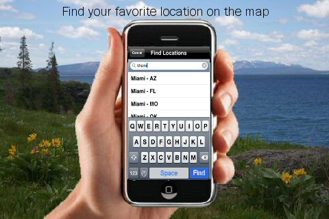
· Use Latitudes and Longitudes to go to your favorite places
· Insert the target/destination ‘Waypoint’ and see in real time your speed, distance and direction to destination
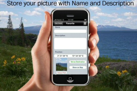
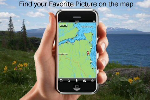
· Insert Unlimited Markers near favorite places on the map
· Search your Favorite points directly
· Zoom, Rotate and Pan fast just by a finger touch
· Navigate and see your GPS position on the map
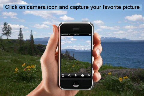
· Geo-Tagged photo management
· Set On/Off Elevation Contours if you feel data is cluttering
What's New in This Release:
· GPS Info Page
· Faster Names Search
What's New in 2.5.1:
· Minor bug Fixed
What's New in 2.5:
· Fully compatible to 4.0
· Improved GPS management in low signal conditions
· Added direction angle information when navigating toward a destination
Like it? Share with your friends!
If you got an error while installing Themes, Software or Games, please, read FAQ.
Supported operating systems:
Apple iOS 10.x (iPad), Apple iOS 10.x (iPhone), Apple iOS 11.x (iPad), Apple iOS 12.x (iPad), Apple iOS 12.x (iPhone), Apple iOS 4.0.x (iPhone), Apple iOS 4.0.x (iPod Touch), Apple iOS 4.2.x (iPad), Apple iOS 4.2.x (iPhone), Apple iOS 4.2.x (iPod Touch), Apple iOS 4.3.x (iPad), Apple iOS 4.3.x (iPhone), Apple iOS 4.3.x (iPod Touch), Apple iOS 5.0 (iPad), Apple iOS 5.0 (iPhone), Apple iOS 5.0 (iPod Touch), Apple iOS 6.0 (iPad), Apple iOS 6.0 (iPhone), Apple iOS 6.0 (iPod Touch), Apple iOS 7.0 (iPad), Apple iOS 7.0 (iPhone), Apple iOS 7.0 (iPod Touch), Apple iOS 8.x (iPad), Apple iOS 8.x (iPhone), Apple iOS 8.x (iPod Touch), Apple iOS 9.x (iPad), Apple iOS 9.x (iPhone), Apple iOS 9.x (iPod Touch), Apple iPhone OS 3.1.x, Apple iPhone OS 3.1.x (iPod Touch), Apple iPhone OS 3.2.x (iPad)
Similar Software:
CoPilot Live Premium HD Europe (iPhone/iPad) CoPilot Live Premium HD Europe (iPhone/iPad) - transforms your 3G iPad into an incredible large-screen in-car sat navigation system.
There's certainly no mistaking the route ahead. CoPilot Live takes full advantage of your iPad's screen to provide easy to follow, crystal clear guidance
Arcipelago Toscano National Park - GPS Map Navigator Arcipelago Toscano National Park - GPS Map Navigator - FlytoMap provides complete, quick and easy to use map applications for navigation for iPhone. Continues in the tradition of offering depth of information and functionality across expected places all over the world, exploring the map you get maximum details obtaining detailed information of every object on the map
Navfree GPS + Street View Spain Navfree GPS + Street View Spain - Navfree is a free GPS navigation solution for iOS devices. The app uses OpenStreetMap data, created and updated by thousands of users from all over the world.
The maps are stored locally on the device, so there is no need for a data connection
Ndrive Argentina Ndrive Argentina - This app will turn your iPhone into a turn by turn voice navigation device.
WHAT YOU ARE BUYING
You are buying a lifetime license of the latest maps. There are no monthly fees or hidden charges.
No data plan is needed to run NDrive software and even when your phone is in roaming, your GPS Navigation from NDrive will run smoothly and uninterupted
TomTom Mexico TomTom Mexico - Tap and go - Using iPhone's innovative technology, the TomTom application lets you tap your way from A to B, putting you in touch with all the best routes. Scroll through the menu, or pinch to zoom in and out on a map using the iPhone's multi-touch display.
Go your own way - Why follow the rest? See your route, your way
Cape Town Map Offline Cape Town Map Offline - This will be perfect when you are traveling and you don't have internet connection. This Offline Maps is not a replacement of Google Maps. It is used when you don't have internet connection and want to use maps
Cleveland(Ohio) World Travel Cleveland(Ohio) World Travel - Map with locate me function makes you free to move.
Background reading always accompanies you on your trip
AT&T FamilyMap AT&T FamilyMap - AT&T customers can now locate family members at any time for a monthly fee on their AT&T mobile phone bill.
Get peace of mind by conveniently locating your child or family member on a map from your Apple iPhone or computer
Navfree GPS France + Street View Navfree GPS France + Street View - Navfree is a free GPS navigation solution for iOS devices. The app uses OpenStreetMap data, created and updated by thousands of users from all over the world.
The maps are stored locally on the device, so there is no need for a data connection
Den Haag (Netherland) Maps Offline Den Haag (Netherland) Maps Offline - This will be perfect when you are traveling and you don't have internet connection. This Offline Maps is not a replacement of Google Maps. It is used when you don't have internet connection and want to use maps
Other Software by developer «Flytomap»:
Mille Lacs Lake - Fishing Mille Lacs Lake - Fishing - Mille Lacs Lake is Minnesota's second largest inland lake. Relatively shallow, the large lake is one of many glacial pothole lakes in the area 100 miles west of Duluth.
Mille Lacs Lake shines especially for fishing activities
Canyonlands National Park - GPS Map Navigator Canyonlands National Park - GPS Map Navigator - FlytoMap provides complete, quick and easy to use map applications for navigation for iPhone. Continues in the tradition of offering depth of information and functionality across expected places all over the world, exploring the map you get maximum details obtaining detailed information of every object on the map
Crater Lake National Park - GPS Map Navigator Crater Lake National Park - GPS Map Navigator - Continues in the tradition of offering depth of information and functionality across expected places all over the world, exploring the map you get maximum details obtaining detailed information of each object on the map
Badlands National Park - Standard Badlands National Park - Standard - Continues in the tradition of offering depth of information and functionality across expected places all over the world, exploring the map you get maximum details obtaining detailed information of each object on the map
Cyprus - GPS Map Navigator Cyprus - GPS Map Navigator - FlytoMap provides complete, quick and easy to use map applications for navigation for iPhone. Continues in the tradition of offering depth of information and functionality across expected places all over the world, exploring the map you get maximum details obtaining detailed information of every object on the map
Wind Cave National Park - GPS Map Navigator Wind Cave National Park - GPS Map Navigator - Continues in the tradition of offering depth of information and functionality across expected places all over the world, exploring the map you get maximum details obtaining detailed information of each object on the map
Marine: Oslo Fjord HD - GPS Map Navigator Marine: Oslo Fjord HD - GPS Map Navigator - FlytoMap provides complete, quick and easy to use map applications for navigation for iPad. Continues in the tradition of offering depth of information and functionality across expected places all over the world, exploring the map you get maximum details obtaining detailed information of every object on the map
Madagaskar - GPS Map Navigator Madagaskar - GPS Map Navigator - FlytoMap provides complete, quick and easy to use map applications for navigation for iPhone. Continues in the tradition of offering depth of information and functionality across expected places all over the world, exploring the map you get maximum details obtaining detailed information of every object on the map
The Peak District National Park - GPS Map Navigator The Peak District National Park - GPS Map Navigator - FlytoMap provides complete, quick and easy to use map applications for navigation for iPhone. Continues in the tradition of offering depth of information and functionality across expected places all over the world, exploring the map you get maximum details obtaining detailed information of every object on the map
Shenandoah National Park - GPS Map Navigator Shenandoah National Park - GPS Map Navigator - Continues in the tradition of offering depth of information and functionality across expected places all over the world, exploring the map you get maximum details obtaining detailed information of each object on the map

")


")


 World Travel")


 Maps Offline")


