Platforms: iPhone, iPad, iPod Touch, Apple iPhone OS
Categories: Travel & Navigation
Upload date: 11 May 13
Developer: Visual IT
License: Commercial
Price: 1.99 $
Downloads: 15
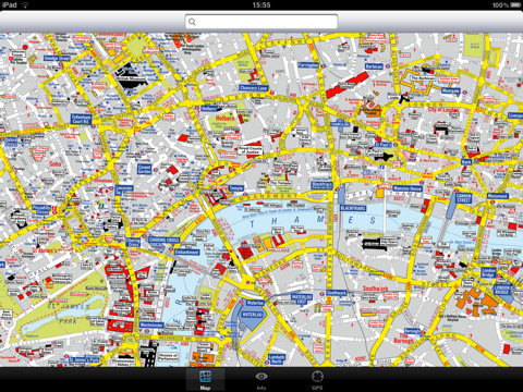
London Visitors A-Z for iPad - The London Visitors A-Z map of central London is designed especially for the tourist. The principal feature of the mapping is the highlighting of places of interest, buildings open to the public, theatres, cinemas, selected shops and stores, main shopping streets, main line and underground railway stations and other locations of interest to the visitor. Road information shown includes A and B roads, bus routes and a selection of principal minor roads.
This map is drawn by real cartographers with the detailed care and human touch of emphasis and colour that A-Z are famous for.
With the maps installed on your device there is never any need for an internet connection enabling you to access the map anywhere and at anytime. This application starts up instantly and can find any location on the map immediately. You can also use your inbuilt location services (GPS, Wifi, etc) to locate your position on the map.
Visual IT has partnered with the “Geographers A-Z Map Company” and negotiated a license to produce this map for iPad users at this very competitive price.
Add this map to one of our “Zuti” route planner maps (the classic “Zuti - London Underground” or the geographically based version “Zuti – London Tube” or if travelling by bus the “Zuti – London Bus”) and you are well equipped to travel anywhere in the central London area.
COVERAGE
The map covers an area extending from Charing Cross to:- St. John's Wood, Regent's Park, St. Pancras International Station, Shoreditch, Tower Bridge, Bermondsey, Newington, Westminster, Sloane Square, South Kensington, Earl's Court, Kensington High Street, Bayswater and Maida Vale.
· Full offline map with inbuilt search facility.
· Colourful clear custom drawn geographically accurate mapping.
· No internet connection required, no data roaming charges, works on all devices.
· GPS location and tracking.
· Streets, Places of interest, Museums and Galleries etc built into the application.
What's New in This Release:
· Updated for iPhone 5 display
· Now a universal app that runs on iPhone and iPad
Like it? Share with your friends!
If you got an error while installing Themes, Software or Games, please, read FAQ.
Supported operating systems:
Apple iOS 10.x (iPad), Apple iOS 10.x (iPhone), Apple iOS 11.x (iPad), Apple iOS 12.x (iPad), Apple iOS 12.x (iPhone), Apple iOS 4.3.x (iPad), Apple iOS 4.3.x (iPhone), Apple iOS 4.3.x (iPod Touch), Apple iOS 5.0 (iPad), Apple iOS 5.0 (iPhone), Apple iOS 5.0 (iPod Touch), Apple iOS 6.0 (iPad), Apple iOS 6.0 (iPhone), Apple iOS 6.0 (iPod Touch), Apple iOS 7.0 (iPad), Apple iOS 7.0 (iPhone), Apple iOS 7.0 (iPod Touch), Apple iOS 8.x (iPad), Apple iOS 8.x (iPhone), Apple iOS 8.x (iPod Touch), Apple iOS 9.x (iPad), Apple iOS 9.x (iPhone), Apple iOS 9.x (iPod Touch)
Similar Software:
Darwin Street Map Darwin Street Map - Lets you find all streets, and many useful locations such as ATM's, parkings, museums, and many others. Remembers where you've been so you can find that parking spot where you left your rental car
Lancaster (CA,USA) Map Offline Lancaster (CA,USA) Map Offline - This will be perfect when you are traveling and you don't have internet connection. This Offline Maps is not a replacement of Google Maps. It is used when you don't have internet connection and want to use maps
Bryce Canyon National Park - Standard Bryce Canyon National Park - Standard - Continues in the tradition of offering depth of information and functionality across expected places all over the world, exploring the map you get maximum details obtaining detailed information of each object on the map
Salzburg Street Map Salzburg Street Map - Lets you find all streets, and many useful locations such as ATM's, parkings, museums, and many others. Remembers where you've been so you can find that parking spot where you left your rental car
Death Valley National Park - GPS Map Navigator Death Valley National Park - GPS Map Navigator continues in the tradition of offering depth of information and functionality across expected places all over the world, exploring the map you get maximum details obtaining detailed information of each object on the map
Zagreb (Croatia) Map Offline Zagreb (Croatia) Map Offline - This will be perfect when you are traveling and you don't have internet connection. This Offline Maps is not a replacement of Google Maps. It is used when you don't have internet connection and want to use maps
Google Maps (iPhone) Google Maps (iPhone) - Google Maps is a comprehensive map solution for iOS devices. It offers accurate maps, voice guided turn-by-turn driving directions, live traffic information, public transit directions, Street View, and more.
With Google Maps, you can easily find points of interest around you, such as restaurants, pubs, shops, hotels, and more
Cyprus - GPS Map Navigator Cyprus - GPS Map Navigator - FlytoMap provides complete, quick and easy to use map applications for navigation for iPhone. Continues in the tradition of offering depth of information and functionality across expected places all over the world, exploring the map you get maximum details obtaining detailed information of every object on the map
Budapest Travel Guide by Triposo Budapest Travel Guide by Triposo - Free interactive travel guide to Budapest. Works offline and has a detailed map.
About our guide
We make great, interactive travel guides.
To make our guides we use the content that is freely available. Open content sites like Wikitravel, Wikipedia, World66 and Openstreetmap are among the best resources for any traveler
Other Software by developer «Visual IT»:
Tube 2 New York City Pro (UIQ) Tube 2 New York City Pro (UIQ) - This map package for Tube 2 consists of a fully scrollable detailed map of the New York City MTA subway system and linked high quality street maps of Manhattan. Also included are additional reference maps of the rail systems surrounding NYC
San Francisco Metro for iPad by Zuti San Francisco Metro for iPad by Zuti - The new San Francisco Metro 10 application makes it easy to travel in and around the city using the Metro (BART), Streetcar, Light Rail(MUNI), Ferry and Presidio shuttle bus services
Rome Metro 10 for iPad Rome Metro 10 -The Zuti Rome Metro application is a superb geographically based map and route planner for the Metro, Tram, Urban and Regional rail systems. Unlike old fashioned schematic style maps this product contains a geographically accurate central area showing major streets, parks and places of interest etc, allowing the user to easily get their bearings
Tube 2 Portland (Palm OS) Tube 2 Portland (Palm OS) - This map package for Tube 2 consists of a fully scrollable detailed map of the Portland rail system.
Plan journeys on this system, list details of the quickest routes and see a superb animated display of your journey tracking around the system map
Digital Camera Guide (UIQ) Digital Camera Guide (UIQ) - An essential guide for anyone new to the world of digital photography. In a simple easy to read format with superb photographs it helps you to get the most from your camera and explains how many of the complicated features of your camera work.
Index of subjects covered:
- Camera Controls
London Bus London Bus - The new Zuti London Bus map has finally arrived, making it easy to travel by bus anywhere in central London. This clear and colourful map covers a detailed street level area of 6 miles by 4 miles and includes over 1300 bus stops and 189 bus routes
Tube 2 Boston Pro (Palm OS) Tube 2 Boston Pro (Palm OS) - This map package for Tube 2 consists of a fully scrollable detailed map of the Boston metro & commuter rail system and linked street maps of central Boston.
Plan journeys on the metro system, list details of the quickest routes and see a superb animated display of your journey tracking around the system map
Tube 2 Barcelona (UIQ) Tube 2 Barcelona (UIQ) - This map package for Tube 2 consists of a fully scrollable detailed map of the Barcelona metro & rail system.
Plan journeys on the metro system, list details of the quickest routes and see a superb animated display of your journey tracking around the system map
Tube 2 Berlin (UIQ) Tube 2 Berlin (UIQ) - This map package for Tube 2 consists of a fully scrollable detailed map of the Berlin Metro (U-Bahn/S-Bahn).
Plan journeys on this system, list details of the quickest routes and see a superb animated display of your journey tracking around the system map.
Berlin is the capital and largest city in Germany
Tube Sydney Pro (UIQ) This award winning and highly acclaimed application that guides you around the Sydney rail system is now available for your Sony Ericsson P800 / P900 / P910 in a pro version

")


 Map Offline")


 Map Offline")

")


")


")
")

")
")
")
")