Platforms: iPhone, iPad, iPod Touch, Apple iPhone OS
Categories: Travel & Navigation
Upload date: 1 Sep 11
Developer: Flytomap
License: Commercial
Price: 4.99 $
Downloads: 20
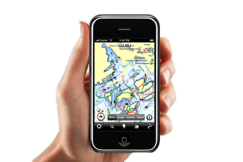
Lakes: Wisconsin - FlytoMap provides complete, quick and easy to use map applications for navigation for iPhone. Continues in the tradition of offering depth of information and functionality across expected places all over the world, exploring the map you get maximum details obtaining detailed information of every object on the map.
FlytoMap processes different types of maps for navigation for different categories:
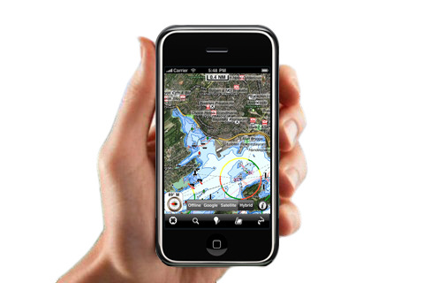
WATER MAPS (Marine):
Water map navigator is the new ‘Marine Navigator for iPhone’ contains embedded Electronic Nautical Charts (ENC) from NOAA compressed to a large coverage. You can now download the application and transform your iPhone in a chart plotter with best NOAA, ENC S57 cartography; which includes Anchoring areas, Fishing areas, restriction areas, obstructions, rocks, Buoys, Beacons, Lights, Depth contours with Values display on map, Spot Soundings and more. The only marine app available in the market with such huge information. Every effort is made to be as accurate as possible when presenting information for every destination.
PARK MAPS:
Park map applications are extremely advanced contains embedded electronic charts with all information collected from the National Park Service and local sources. The maps contain all multiple trails (Hiking, biking, Stairway trails, Bicycle trails, Equestrian trails etc.,) and Point of interests (POI) like Campgrounds, Eating places, Ranger Stations, Picnic areas, Boat/Canoe launching, Parking areas etc., which are provided depending on the relevant park areas they exist.
LAKE MAPS:
We offer high quality lake maps with detailed information and important features compressed to assure the larger coverage in USA region. Lake maps contain most important DNR lakes with detailed ‘Depth Contours, Boat Ramps, Fishing spots etc. Also includes Trails, Roads and Railways information.
TRAVEL MAPS:
These Maps treat you mostly with information of both Marine and terrain correspondingly. These are the most preferable Maps to travel especially for fascinating recreational voyages, map focus the best Beach spots along the Coast line, Major ports, Sailing, Fishing, Picnic areas, Parks, Hiking, Biking, Clubs, restaurants, Famous Hotels, Museums, Shopping areas, and much more.
· Use Latitudes and Longitudes to go to your favorite places
· Insert the target/destination 'Waypoint' and see in real time your speed, distance and direction to destination
· Insert Unlimited Markers near favorite places on the map
· Search your Favorite points directly
· Zoom, Rotate and Pan fast just by a finger touch
· Navigate and see your GPS position on the map
· Geo-Tagged photo management
· Set On/Off Elevation Contours if you feel data is cluttering
What's New in This Release:
· GPS Info Page
· Faster Names Search
What's New in 2.5.1:
· Fully compatible to 4.0
· Improved GPS management in low signal conditions
· Added direction angle information when navigating toward a destination
Like it? Share with your friends!
If you got an error while installing Themes, Software or Games, please, read FAQ.
Supported operating systems:
Apple iOS 10.x (iPad), Apple iOS 10.x (iPhone), Apple iOS 11.x (iPad), Apple iOS 12.x (iPad), Apple iOS 12.x (iPhone), Apple iOS 4.0.x (iPhone), Apple iOS 4.0.x (iPod Touch), Apple iOS 4.2.x (iPad), Apple iOS 4.2.x (iPhone), Apple iOS 4.2.x (iPod Touch), Apple iOS 4.3.x (iPad), Apple iOS 4.3.x (iPhone), Apple iOS 4.3.x (iPod Touch), Apple iOS 5.0 (iPad), Apple iOS 5.0 (iPhone), Apple iOS 5.0 (iPod Touch), Apple iOS 6.0 (iPad), Apple iOS 6.0 (iPhone), Apple iOS 6.0 (iPod Touch), Apple iOS 7.0 (iPad), Apple iOS 7.0 (iPhone), Apple iOS 7.0 (iPod Touch), Apple iOS 8.x (iPad), Apple iOS 8.x (iPhone), Apple iOS 8.x (iPod Touch), Apple iOS 9.x (iPad), Apple iOS 9.x (iPhone), Apple iOS 9.x (iPod Touch), Apple iPhone OS 3.1.x, Apple iPhone OS 3.1.x (iPod Touch), Apple iPhone OS 3.2.x (iPad)
Similar Software:
Apeldoorn Street Map Apeldoorn Street Map - Lets you find all streets, and many useful locations such as ATM's, parkings, museums, and many others. Remembers where you've been so you can find that parking spot where you left your rental car
Santa Cruz Street Map Santa Cruz Street Map - Lets you find all streets, and many useful locations such as ATM's, parkings, museums, and many others. Remembers where you've been so you can find that parking spot where you left your rental car
Avignon Map and Walking Tours Avignon Map and Walking Tours - This Lite version of the walking tours application comes with a detailed and fully functional city map to assist you explore the city and locate sights. City map functions in this app include: street name and business (restaurants, cafes, etc
Addis Ababa Street Map Addis Ababa Street Map - Lets you find all streets, and many useful locations such as ATM's, parkings, museums, and many others. Remembers where you've been so you can find that parking spot where you left your rental car
High Definition Estonia Atlas (Zoom) - GPS Travel Companion High Definition Estonia Atlas (Zoom) - GPS Travel Companion - Each map can be amplified several times.
The special customized Atlas Guide can get information such as:
flags
maps
travel information
touristic top locations
history
currencies
trivia
humor
pictures
videos
museums information
restaurant information
accommodations / hotel
Miami Travel Guide - Lonely Planet Comprehensive maps ensure you're never lost in this vast cultural playground; detailed history, culture and language chapters give you an essential entree to local life and independent, in-depth research means you'll never need to second guess
Lake Powell - Fishing Lake Powell - Fishing - Lake Powell is the ultimate recreational spot for millions of visitors having 186 miles length with 1960 miles of shoreline for excellent activities.
Lake Powell is well known for activities like Swimming, Boating and Kayaking, Fishing, Scuba diving, Snorkeling, Water skiing and sightseeing. Photographic opportunities around are plentiful
Brisbane Street Map Brisbane Street Map - Lets you find all streets, and many useful locations such as ATM's, parkings, museums, and many others. Remembers where you've been so you can find that parking spot where you left your rental car
Utrecht (Netherland) Map Offline Utrecht (Netherland) Map Offline - This will be perfect when you are traveling and you don't have internet connection. This Offline Maps is not a replacement of Google Maps. It is used when you don't have internet connection and want to use maps
Grenadines & Grenada HD - Travel Map Navigator Grenadines & Grenada HD - Travel Map Navigator FlytoMap provides complete, quick and easy to use map applications for navigation. Continues in the tradition of offering depth of information and functionality across expected places all over the world, exploring the map you get maximum details obtaining detailed information of every object on the map
FlyToMap GPS - All in One FlyToMap GPS - All in One - FlytoMap provides complete, quick and easy to use map applications for navigation for iPhone. Continues in the tradition of offering depth of information and functionality across expected places all over the world, exploring the map you get maximum details obtaining detailed information of every object on the map
Phuket Island - GPS Map Navigator Phuket Island - GPS Map Navigator - FlytoMap provides complete, quick and easy to use map applications for navigation for iPhone. Continues in the tradition of offering depth of information and functionality across expected places all over the world, exploring the map you get maximum details obtaining detailed information of every object on the map
Wind Cave National Park - Topo Wind Cave National Park - Topo - Continues in the tradition of offering depth of information and functionality across expected places all over the world, exploring the map you get maximum details obtaining detailed information of each object on the map
Yosemite National Park - Standard Yosemite National Park - Standard - Continues in the tradition of offering depth of information and functionality across expected places all over the world, exploring the map you get maximum details obtaining detailed information of each object on the map
Great Basin National Park - GPS Map Navigator Great Basin National Park - GPS Map Navigator - Continues in the tradition of offering depth of information and functionality across expected places all over the world, exploring the map you get maximum details obtaining detailed information of each object on the map
Catoctin Mountain Park - GPS Map Navigator Catoctin Mountain Park - GPS Map Navigator - Continues in the tradition of offering depth of information and functionality across expected places all over the world, exploring the map you get maximum details obtaining detailed information of each object on the map
Yorkshire Dales National Park - GPS Map Navigator Yorkshire Dales National Park - GPS Map Navigator - FlytoMap provides complete, quick and easy to use map applications for navigation for iPhone. Continues in the tradition of offering depth of information and functionality across expected places all over the world, exploring the map you get maximum details obtaining detailed information of every object on the map
Rhodes Island - GPS Map Navigator Rhodes Island - GPS Map Navigator - FlytoMap provides complete, quick and easy to use map applications for navigation. Continues in the tradition of offering depth of information and functionality across expected places all over the world, exploring the map you get maximum details obtaining detailed information of every object on the map

")


 - GPS Travel Companion")


 Map Offline")


