Platforms: iPhone, iPad, iPod Touch, Apple iPhone OS
Categories: Travel & Navigation
Upload date: 19 Oct 11
Developer: VITO Technology
License: Freeware
Downloads: 87
GPS Guide Vokrug Sveta - VOKRUG SVETA GPS-guide, created by VOKRUG SVETA publishing house, is a one-of-a-kind application for the independent traveler. This application allows owners of portable devices with GPS receivers to create exciting and intellectually stimulating itineraries on their very own.
The GPS-guide consists of the VS Guide navigation program and multimedia itineraries.
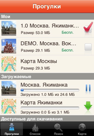
The application consists of two parts: the free-of-charge downloadable Client and the Add-on modules containing comprehensive information about each of a city’s noteworthy neighborhoods or districts. These Add-on modules we call “itineraries”.
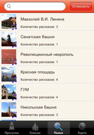
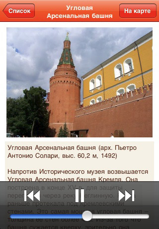
The itineraries are downloaded through the application. Each one includes an audio-guide along with photos of select “places of interest” and their descriptions. When the download of the desired itinerary is complete, a map of the area becomes available.
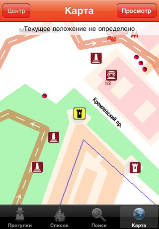
Having loaded the appropriate itinerary, you can set out on a walk as you listen to the virtual guide – your headphones on and the device in your pocket. The application pinpoints your location and draws your attention to all visible “places of interest.” There are no fixed routes. The VS guide adapts automatically to any direction.
The application allows you to look at photos of the nearest "place of interest," read the accompanying descriptions, and locate yourself on the map. "Places of interest" are sorted in a list according to their distance from your location. It is also possible to view them on the map.
The VS guide also has a special “virtual walk” mode for those who like to prepare ahead of time or for those who do not have GPS-receivers. This mode allows you to listen to the audio-guide, look at the pictures, and enjoy all the benefits of travel without ever leaving your home.
Like it? Share with your friends!
If you got an error while installing Themes, Software or Games, please, read FAQ.
Supported operating systems:
Apple iOS 10.x (iPad), Apple iOS 10.x (iPhone), Apple iOS 11.x (iPad), Apple iOS 12.x (iPad), Apple iOS 12.x (iPhone), Apple iOS 4.0.x (iPhone), Apple iOS 4.0.x (iPod Touch), Apple iOS 4.2.x (iPad), Apple iOS 4.2.x (iPhone), Apple iOS 4.2.x (iPod Touch), Apple iOS 4.3.x (iPad), Apple iOS 4.3.x (iPhone), Apple iOS 4.3.x (iPod Touch), Apple iOS 5.0 (iPad), Apple iOS 5.0 (iPhone), Apple iOS 5.0 (iPod Touch), Apple iOS 6.0 (iPad), Apple iOS 6.0 (iPhone), Apple iOS 6.0 (iPod Touch), Apple iOS 7.0 (iPad), Apple iOS 7.0 (iPhone), Apple iOS 7.0 (iPod Touch), Apple iOS 8.x (iPad), Apple iOS 8.x (iPhone), Apple iOS 8.x (iPod Touch), Apple iOS 9.x (iPad), Apple iOS 9.x (iPhone), Apple iOS 9.x (iPod Touch), Apple iPhone OS 3.1.x, Apple iPhone OS 3.1.x (iPod Touch), Apple iPhone OS 3.2.x (iPad)
Similar Software:
ProGuides - Bora Bora ProGuides - Bora Bora - Signs change, culture changes, and familiar streets are exchanged for more exotic ones. The challenge is how to see it all. How to take it all in without wasting your time, your energy or your budget. The answer is ProGuides.
· Great Introductions help you understand the local culture and history
Versailles Walking Tours and Map This revolutionary application presents you several self-guided walking tours to see the best of the city, and it comes with detailed tour route maps and powerful navigation features to guide you from one sight to the next
Laos travel guide Laos travel guide - It provides travel guides such as: General info, Districts, Getting there, Transport, Sights, Entertainment, Shopping, Eat, Drink, Place to stay, Contact, Stay safe
Verona Travel Guides Offline travel guide with super fast loading page. No internet connection needed
The Most Popular Sights, Berlin The Most Popular Sights, Berlin - Filled with more monuments and famous attractions than you could possibly see in one day, sightseeing in Berlin can get a little overwhelming. This tour takes you to Berlin's most popular and recognizable sights within the city center giving you a comprehensive overview and a great introduction
Newport Beach Insider Newport Beach Insider - Newport Beach is a two-sided city. There's the high style, luxurious side of fancy shops, fancy restaurants and fancy homes. And there's the casual, affordable side of lazy days on the beach, paddleboarding in the harbor, grabbing a frozen banana before walking around Balboa Island and then watching the sun set over the ocean
London Travel guide London Travel guide - It provides travel guides such as: General info, Districts, Getting there, Transport, Sights, Entertainment, Shopping, Eat, Drink, Place to stay, Contact, Stay safe
Chubu Travel Guide Offline travel guide with super fast loading page. No internet connection needed
Tunisia Travel Guide Tunisia Travel Guide - It provides travel guides such as: General info, Districts, Getting there, Transport, Sights, Entertainment, Shopping, Eat, Drink, Place to stay, Contact, Stay safe
Lonely Planet Munich City Guide Lonely Planet Munich City Guide - Browse guidebook chapters, discover neighbourhoods & plan your itinerary.
· Offline maps
· Location-based navigation
· Hundreds of points of interest
· professional image gallery
· Personalised favourites
· Editorial content
What's New in This Release:
· iOS4 compatibility
Other Software by developer «VITO Technology»:
Solar Walk Solar Walk - Let's find out more about our neighboring planets in the Universe, play around with them determining the speed of circulation, time, choosing a particular planet to become the center of the Universe, seeing the moons of Saturn, Jupiter, Mars and Urano. The 3D model in the Solar Walk app is the exact reproduction of the real solar system
Map of Poland Map of Poland - A map of Poland. Good for intercity travels with SmartMap.
Layers include:
Towns
Settlements
Airports
Roads
Railroads
Rivers
Inland water
Administrative borders
International borders
Trees
Map scale is 1:1 million.
Good for use with any version of SmartMap. SmartMap can be purchased here
VITO RingtoneEditor VITO Ringtone Editor is the quickest way to create your own ringtones. All you need to do is listen to the melody and choose the part of it you want to assign as a ringtone. User-friendly intuitive interface simplifies the process greatly
Map of North Dakota (US State) Map of North Dakota (US State) - A map of the North Dakota by VITO Technology. Good for intercity travels with SmartMap.
SmartMap is a mobile device application which uses vector and raster maps. It is compatible with any NMEA protocol GPS receiver (Compact Flash socket, serial port, BlueTooth or sleeve)
VITO ButtonMapper ButtonMapper is a system application that allows creating custom commands for hardware buttons of your PocketPC
GoodWin GoodWin is a next generation touch oriented Windows Mobile launcher and task switcher for Pocket PC.
Launcher and Task Manager
GoodWin is a touch-oriented Windows Mobile launcher and task manager.
GoodWin is a complete replacement for Today screen and Start Menu
Map of New Hampshire (US State) Map of New Hampshire (US State) - A map of the New Hampshire by VITO Technology. Good for intercity travels with SmartMap and VITO SmartNavigator.
SmartMap is a mobile device application which uses vector and raster maps. It is compatible with any NMEA protocol GPS receiver (Compact Flash socket, serial port, BlueTooth or sleeve)
Map of Slovenia Map of Slovenia - A map of Slovenia. Good for intercity travels with SmartMap.
Layers include:
Towns
Settlements
Airports
Roads
Railroads
Rivers
Inland water
Administrative borders
International borders
Trees
Map scale is 1:1 million.
Good for use with any version of SmartMap. SmartMap can be purchased here
VITO CopyPaste Smartphone VITO CopyPaste - System utility that greatly simplifies managing your Smartphone. CopyPaste does exactly what its name says in any editable field edit box. Copy or cut the info from an edit box and paste it to another one. You can also select the necessary part of the edit box contents for copying or cutting to another editable field. CopyPaste saves your time and ink
Map of Turkey Map of Turkey - A map of Turkey, divided into 67 smaller territories for the ease of use. Good for intercity travels with SmartMap.
Layers include:
Towns
Settlements
Airports
Roads
Railroads
Rivers
Inland water
Administrative borders
International borders
Trees
Map scale is 1:1 million

")


")


")


