Platforms: iPhone, iPad, iPod Touch, Apple iPhone OS
Categories: Travel & Navigation
Upload date: 6 Aug 13
Developer: Hunter Research and Technology
License: Commercial
Price: 3.99 $
Downloads: 39
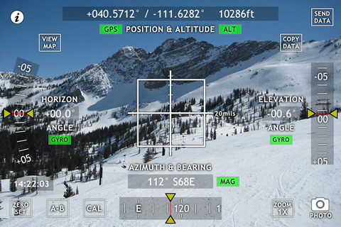
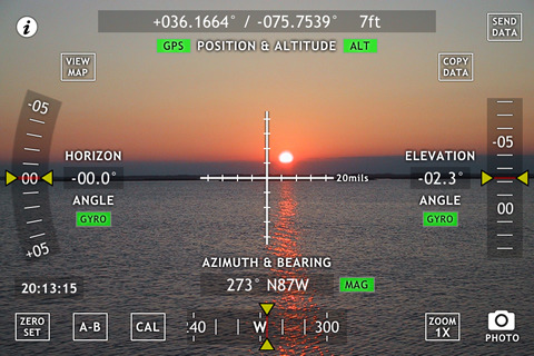
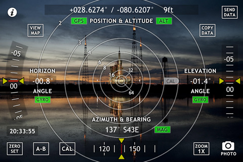
Theodolite - Based on a centuries-old astronomical instrument, Theodolite is a cool multi-function augmented reality app for the iPhone that serves as a compass, GPS, map, zoom camera, rangefinder, and two-axis inclinometer. Theodolite overlays real time information about position, altitude, bearing, and horizontal/vertical inclination on the iPhone’s live camera image, like an electronic viewfinder. Uses are endless, and the app is great for hiking, boating, hunting, golf, sports, sightseeing, navigation, and finding your way around. The app is used extensively by surveyors, geologists, architects, engineers, military personnel, and search and rescue workers around the world.
Theodolite lets you take camera images and screenshots directly from the app, with 2X and 4X digital zoom options. You can choose to stamp geographical data and custom notes directly on the saved image for later reference. View your current position on the built in map view, with standard, satellite, and hybrid modes.
The flagship of the Theodolite series, Pro includes features for serious users like a reference angle mode, an A-B calculator for height, distance, heading, position, triangulation, and relative angles, e-mail export with KML data, system-wide clipboard integration, percent grade display, mil compass readout, optical rangefinders (including a mil-based reticle), military grid reference system (MGRS) coordinates, universal transverse Mercator (UTM) coordinates, and four latitude/longitude formats.
Theodolite works on any iPhone. GPS functionality requires an iPhone 3G, 3GS, or 4. Compass functionality requires an iPhone 3GS or 4. On iPhone 4, compass and inclinometer data are augmented by the gyro, and the application uses high res artwork for the Retina Display.
What's New in This Release:
· Optional "Datum Pack" in-app purchase that adds over 220 new geodetic datums to the app for more accurate position and altitude computation from GPS data. Datums include NAD-27, NAD-83, OSGB-36, ED-50, and hundreds of others, covering regions and countries on all continents around the world.
· Four new position formats for the UK and Ireland, including British National Grid and Irish National Grid. Absolute and Subgrid relative Eastings and Northings are given.
· Revised hardware status indicators and status screen.
What's New in 3.1:
· Support for iOS 6 and iPhone 5. Improvements to map marker sharing. Improved rendering of map markers, compass rose, and azimuth pointer. Live map markers, with realtime distance/heading updates (relative to current position). Map marker sharing and e-mail export integration with Gaia GPS. Improved handling of MGRS, UTM, and UTM-B search/lookup on map screen using format prefixes (see user manual for details). Variable 4X-24X rangefinder scope reticle. SLR camera style round wire reticle with focus prism and exposure indicator. Team tracking available through in-app purchase (see user manual for details).
What's New in 3.0:
· Movie recording, with optional screen/watermark overlays and multiple video quality settings. Three large-format stadiametric rangefinders (sniper/artillery/hunter style, showing distance multipliers, yards, or meters). Revised position formats with new decimal minutes option. Larger font sizing for photo data stamp watermark, with three color options. Onscreen indicator for magnetic declination errors. Bug fix to e-mail export URLs. Numerous performance improvements and tweaks.
Like it? Share with your friends!
If you got an error while installing Themes, Software or Games, please, read FAQ.
Supported operating systems:
Apple iOS 10.x (iPad), Apple iOS 10.x (iPhone), Apple iOS 11.x (iPad), Apple iOS 12.x (iPad), Apple iOS 12.x (iPhone), Apple iOS 4.3.x (iPad), Apple iOS 4.3.x (iPhone), Apple iOS 4.3.x (iPod Touch), Apple iOS 5.0 (iPad), Apple iOS 5.0 (iPhone), Apple iOS 5.0 (iPod Touch), Apple iOS 6.0 (iPad), Apple iOS 6.0 (iPhone), Apple iOS 6.0 (iPod Touch), Apple iOS 7.0 (iPad), Apple iOS 7.0 (iPhone), Apple iOS 7.0 (iPod Touch), Apple iOS 8.x (iPad), Apple iOS 8.x (iPhone), Apple iOS 8.x (iPod Touch), Apple iOS 9.x (iPad), Apple iOS 9.x (iPhone), Apple iOS 9.x (iPod Touch)
Similar Software:
Theodolite Pro Based on a centuries-old astronomical instrument, Theodolite is a cool multi-function augmented reality app for the iPhone that serves as a compass, GPS, map, zoom camera, rangefinder, and two-axis inclinometer
Speedometer xPro Speedometer xPro - Speedometer xPro is a handy mobile application that can tell you how fast you are moving. The app uses the GPS receiver built into your iPhone, iPad or iPod touch to detect your current speed and shows you the result on an analog or digital meter.
Speedometer xPro can display the speed using several units of measurement including km/h, mph and knots
Speedometer Speedometer - Want to know how fast you are going? Speedometer is a full-featured, simple to use speedometer for the iPhone!
Speedometer is for entertainment only, so have fun! It's pretty accurate. Speedometer makes use of GPS
Altimeter Digital GPS + Map Viewer + Camera + Climb Calc Altimeter Digital GPS + Map Viewer + Camera + Climb Calc - The most accurate and handy Altimeter is here. It gives you the altitude wherever you are.
Simply start the application and altitude will appear in a second, No setup required. You can also adjust Altitude in Feet or Meter as per your requirement. Special feature saved your Max climb rate value
A+ German Voice Compass (Deutsch) Kompass A+ German Voice Compass (Deutsch) Kompass - Finally a German Voice (Talking) compass for the iPhone. With this application you will be able to hear your iPhone guiding you.
Every time you change heading, the iPhone will notify you via "voice".
This application will tell you by means of voice the heading using the native compass of the iPhone 3GS (only)
Analog Compass w/Voice Analog Compass w/Voice - Finally a Voice (Talking) compass for the iPhone. With this application you will be able to hear your iPhone guiding you.
Every time you change heading, the iPhone will notify you via "voice".
This application will tell you by means of voice the heading using the native compass of the iPhone 3GS (only)
GyroCompass 3D GyroCompass 3D - Augmented reality comes to the new iPod Touches! Tap the Gyrocompass 3D application on your iPhone 4 or 4th generation iPod Touch to turn it into a fully functioning three-dimensional compass
Bear Grylls - Compass Bear Grylls - Compass - Having a compass is one thing but knowing how to use it is what really matters. A critical tool for navigation, this application gives you an easy to use compass, an overview and video with Bear and special night mode should you need it
Talking Speedometer (miles) Talking Speedometer (miles) - Finally a Voice Speedometer for your iPhone.
You can set up a MAX SPEED, as soon as you reach the specified speed, the app will start "beeping" till you lower your speed below the specified maximum.
If you are having difficulty reading your cars speedometer while driving, this application is perfect for you
A+ Spanish Voice Compass (Brujula) A+ Spanish Voice Compass (Brujula) - Finally a Spanish Voice (Talking) compass for the iPhone. With this application you will be able to hear your iPhone guiding you.
Every time you change heading, the iPhone will notify you via "voice".
This application will tell you by means of voice the heading using the native compass of the iPhone 3GS (only)
Other Software by developer «Hunter Research and Technology»:
Theodolite Basic Based on a centuries-old astronomical instrument, Theodolite Basic is a cool multi-function augmented reality app for the iPhone that serves as a compass, GPS, map, zoom camera, and two-axis inclinometer
greenMeter GreenMeter is an application for the iPhone and iPod Touch that computes your vehicle's power and fuel usage characteristics and evaluates your driving to increase efficiency, reduce fuel consumption and cost, and lower your environmental impact
Theodolite Free Theodolite Free Based on a centuries-old astronomical instrument, Theodolite Free is a cool multi-function augmented reality app for the iPhone that serves as a compass, GPS, zoom scope, and two-axis inclinometer
Theodolite Pro Based on a centuries-old astronomical instrument, Theodolite is a cool multi-function augmented reality app for the iPhone that serves as a compass, GPS, map, zoom camera, rangefinder, and two-axis inclinometer
ODAT Tracker This application tracks deals from backcountry.com's "one deal at a time" (ODAT) sites
Butterfly Collection Butterfly Collection - Roam the world from your iPhone or iPod Touch to explore diverse species of butterflies and moths. Butterfly Collection showcases 240 members of the fascinating and beautiful order of insect known as Lepidoptera (ancient Greek for "scale wing"), using photographs of actual insects
gyroLens gyroLens - Ever have problems taking that perfect photo? Can't frame a straight shot? Need help getting a level image? Use gyroCam! This full-featured camera app has a killer new feature: it automatically levels photos in real time, while shooting
Flow (iPhone) Flow (iPhone) is a handy fluid dynamics app for the iPhone and iPod Touch. The software implements 1D compressible flow equations, normal and oblique shock relations, laminar and turbulent flat plate boundary layer development, standard atmosphere modeling, and the gas properties of air at sea level
Wx for iPad Wx for iPad The venerable U.S. weather app Wx is now available for iPad! Wx displays current conditions, forecasts, alerts, and radar for U.S. locations using high fidelity XML data from the U.S. National Weather Service

")


 Kompass")


")
")


")
