Platforms: iPhone, iPad, iPod Touch, Apple iPhone OS
Categories: Travel & Navigation
Upload date: 6 Jul 11
Developer: Visual IT
License: Freeware
Downloads: 92
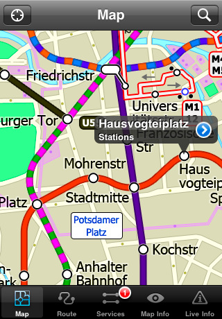
Berlin Metro by Zuti - The new Berlin Metro map makes it easy to travel in and around the city using the Metro (U-Bahn) Suburban Rail (S-Bahn) and Tram (MetroTram and Straßenbahn) systems. Unlike old fashioned schematic style maps this product contains a geographically accurate central area showing major streets, parks and places of interest etc, allowing the user to easily get their bearings.
MAP
The map is hand drawn by Visual IT and provides a unique geographically based view of Berlin with many places of interest drawn directly on the background so you can easily get your bearings when traveling around the city. You can also use your inbuilt GPS to accurately locate and track yourself within the city centre and see the nearest transportation stop and distance to it. This is the only public transportation route planner with this ability.
Tap on the map for location information, use the inbuilt search feature or choose from a list of locations. Places of interest, museums, hotels, parks, restaurant, shops, hospitals, streets, etc, are also included. The route planner will automatically suggest the nearest station to any place of interest you select.
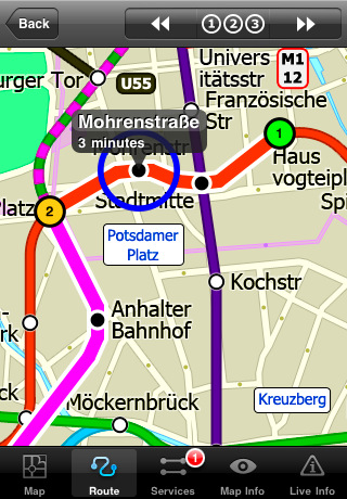
MINUTE MAP
Another great feature is the “Minute Map” option which allows you to see the travel times from a start point to all other locations on the map. This is a unique way to view the topology of a city and gauge traveling times.
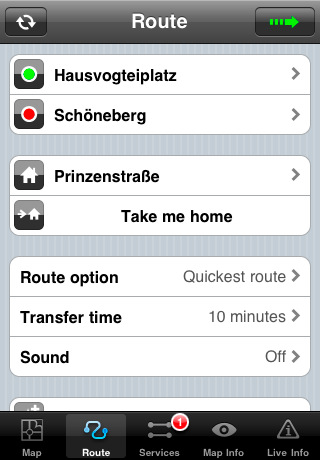
ROUTING
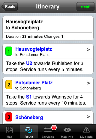
The application does not require an internet connection and will always be available to display a clear and detailed view of the city transport systems, plus list and animate the optimum route for your journey. This product provides the fastest route calculations of any mobile routing application (virtually instantaneous) using actual published journey times with the ability to select the quickest route or the route with the least changes.
· Full offline map and routing, no internet connection required.
· Colourful clear custom drawn geographically accurate mapping.
· Animates the route and allows tracking of the journey using GPS
· Instantly see the route of any transport service drawn on the map.
· Save and recall favourite and recent journeys.
· Take me home feature.
· Unique "Minute Map" feature allows quick view of all journey times from a start location.
· Services can be turned on or off, routing round problems.
· Works on iPhone or iPod and in landscape or portrait mode.
· GPS location and tracking.
· Streets, Places of interest etc built into the application.
What's New in This Release:
· Minor map update
Like it? Share with your friends!
If you got an error while installing Themes, Software or Games, please, read FAQ.
Supported operating systems:
Apple iOS 10.x (iPad), Apple iOS 10.x (iPhone), Apple iOS 11.x (iPad), Apple iOS 12.x (iPad), Apple iOS 12.x (iPhone), Apple iOS 4.0.x (iPhone), Apple iOS 4.0.x (iPod Touch), Apple iOS 4.2.x (iPad), Apple iOS 4.2.x (iPhone), Apple iOS 4.2.x (iPod Touch), Apple iOS 4.3.x (iPad), Apple iOS 4.3.x (iPhone), Apple iOS 4.3.x (iPod Touch), Apple iOS 5.0 (iPad), Apple iOS 5.0 (iPhone), Apple iOS 5.0 (iPod Touch), Apple iOS 6.0 (iPad), Apple iOS 6.0 (iPhone), Apple iOS 6.0 (iPod Touch), Apple iOS 7.0 (iPad), Apple iOS 7.0 (iPhone), Apple iOS 7.0 (iPod Touch), Apple iOS 8.x (iPad), Apple iOS 8.x (iPhone), Apple iOS 8.x (iPod Touch), Apple iOS 9.x (iPad), Apple iOS 9.x (iPhone), Apple iOS 9.x (iPod Touch), Apple iPhone OS 3.1.x, Apple iPhone OS 3.1.x (iPod Touch), Apple iPhone OS 3.2.x (iPad)
Similar Software:
Charlotte(North Carolina) World Travel Charlotte(North Carolina) World Travel - Map with locate me function makes you free to move.
Background reading always accompanies you on your trip
Weekend Trips Near San Antonio Weekend Trips Near San Antonio - GPSmyCity.com's day trips application is a powerful tool for planning your weekend getaways. With a well researched list of weekend getaway spots around the city you live in and the powerful navigation features built-in, you will never be bored on a weekend.
This app works on iPhone, iPad and iPod Touch
Google Places Google Places with Hotpot helps you discover nearby places you'll love. Quickly search for Restaurants, Cafes, Bars and other places, while on the go.
Google Places also makes it easy to quickly rate the places you visit
North America - iGO primo Lite North America - iGO primo Lite - iGO primo Lite is a free route planner and map viewer built upon the experienced iGO Engine employed by GPS navigation devices all over the world. The software uses accurate offline maps which can be used anywhere. This way you don't have to worry about losing your internet connection, and you avoid unnecessary data traffic costs
Priceline Priceline - Power up priceline.com's Hotel Negotiator app and let the Priceline Negotiator, William Shatner, find you last-minute Name Your Own Price hotel rooms that you can book at savings of up to 50%.
· Choose a city and see multiple winning hotel bids for the hotel star levels and parts of the city you want
Best Photography Spots in Cambridge (Lite Version) Best Photography Spots in Cambridge - Cambridge has an evocative array of quintessentially English sights. Use this tour to visit all the must-sees' as well as some off-the-beaten-track spots. As you go collect stunning photographs that capture the essence of this beautiful city
thetrainline thetrainline is the UK's leading independent train ticket retailer. We sell tickets for all train companies to all national destinations.
This is the official application from thetrainline and is perfect for anyone who wants to view UK train times or buy tickets on the move
Hotels by Orbitz Hotels by Orbitz - Simple, powerful, fast and fun. The free Orbitz app designed just for the iPad lets you shop and book hotels effortlessly -- on the couch or on the go. It delivers a vast selection of hotels, powerful comparison tools, and secure booking in just 3 taps. And you can do it all within the vivid, friendly interface of the iPad, from the comfort of your ..
London Bus London Bus - The new Zuti London Bus map has finally arrived, making it easy to travel by bus anywhere in central London. This clear and colourful map covers a detailed street level area of 6 miles by 4 miles and includes over 1300 bus stops and 189 bus routes
Madrid Metro by Zuti Madrid Metro by Zuti - The new Madrid Metro 10 map makes it easy to travel in and around the city using the the Metro, Renfe Rail and Metro Ligero Rail services. Unlike old fashioned schematic style maps this product contains a geographically accurate central area showing major streets, parks and places of interest etc, allowing the user to easily get their bearings
Other Software by developer «Visual IT»:
Tube 2 London Touristic (UIQ) Tube 2 London Touristic (UIQ) - This map package for Tube 2 is the ideal map for the tourist or business traveller who needs to get around London using the Tube system and would like to know just exactly where they are. The map geographically locates all the central stations, making it much more informative than the official topological map
Tube Vienna (UIQ) Tube Vienna (UIQ) - Our award winning and highly acclaimed application that guides you around the metro system of Vienna is now available for your Symbian UIQ phone.
An essential addition to your P800 / P900 / P910 if you travel in or around this city.
· A detailed clear colour map of the Vienna metro system fully scrollable.
· Quick find station utility
GB Major Road Atlas (UIQ) GB Major Road Atlas (UIQ) - This map package is an essential addition to your Tube 2 maps if you drive in and around Great Britain.
This reference map gives you a clear view of all the major roads in the whole of Great Britain, you can use the quick find feature to locate any of the 30,000 + GB towns and villages in the database
Tube Philadelphia (Series 60) Tube Philadelphia (Series 60) - Our highly acclaimed Tube application that guides you around the rail system of Philadelphia is now available for your Series 60 Symbian powered phone. An essential addition to your phone for locals and tourists alike.
· A detailed clear colour map of the Philadelphia rail system fully scrollable.
· Quick find station utility
Rough Guides Map Paris Rough Guides Map Paris... These guides are a series of fantastic interactive maps.
Produced in conjunction with the premier travel publisher Rough Guides.
Discover and explore Paris using full colour interactive linked maps, in this simple to use PDA version of The Rough Guides Paris
Tube Lisbon (Palm OS) Tube Lisbon (Palm OS) - An award winning and highly acclaimed Palm OS application that guides you around therail system of Lisbon. An essential addition to your Palm device for locals and tourists alike.
Tube's features include:
A detailed clear colour (or grey scale) map of the transport system fully scrollable.
Quick find station utility
Tube 2 Madrid (UIQ) Tube 2 Madrid (UIQ) - This map package for Tube 2 consists of a fully scrollable detailed map of the Madrid metro system.
Plan journeys on this system, list details of the quickest routes and see a superb animated display of your journey tracking around the system map
Tube Moscow (Palm OS) Tube Moscow (Palm OS) - An award winning and highly acclaimed Palm OS application that guides you around the complex metro system of Moscow. An essential addition to your Palm device for locals and tourists alike.
Tube's features include:
A detailed clear colour map of the Moscow metro system fully scrollable.
Quick find station utility
Tube 2 Engine (UIQ3) Tube 2 Engine (UIQ3) - Transform your PDA into a fully scrollable detailed map of one of the worlds subway or metro systems.
See your journeys come alive with a superb animated display.
Save hours by automatically having the quickest routes to hand, with all the details you need including line changes, platform directions and accurate journey times
Tube Hamburg (Palm OS) Tube Hamburg (Palm OS) - An award winning and highly acclaimed Palm OS application that guides you around the metro (S-Bahn / U-Bahn) system of Hamburg. An essential addition to your Palm device for locals and tourists alike.
Tube's features include:
A detailed clear colour (or grey scale) map of the transport system fully scrollable.
Quick find station utility

")


 World Travel")


")


")
")
")
")

")
")
")
")
")