Platforms: iPhone, iPad, iPod Touch, Apple iPhone OS
Categories: Travel & Navigation
Upload date: 26 Nov 11
Developer: Visual IT
License: Freeware
Downloads: 81
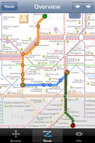
Berlin Metro 09 - The "Berlin Metro 09" application is a superb interactive map and route planner for the Berlin Metro (U-Bahn) and Suburban rail (S Bahn) systems. You can also use your inbuilt GPS (will also work with iPod Touch devices) to accurately locate and see the nearest transportation stop and distance to it. This application is one in a worldwide series of "Tube" maps from Visual IT who have been producing public transportation maps for mobile devices for many years.
SPONSORSHIP
This product is brought to you free of charge through the sponsorship of the Berlin transport authority VBB (Verkehrsverbund Berlin-Brandenburg).
MAP
Tap on the map for station information, use the inbuilt search feature or choose from a list of locations. Places of interest, museums, parks, shops, universities, theatres, etc, are also included. The route planner will automatically suggest the nearest station to any place of interest you select.
INTERNET CONNECTION
The map and routing does not require an internet connection and you will not be charged data connection fees. This also means the application runs successfully underground and on an iPod Touch. The only feature that requires an internet data connection is the “Live Info” which is optional and if used only requires a small amount of data.
ROUTING
Does not require an internet connection and will always be available to display a clear and detailed view of the city transport systems, plus list and animate the optimum route for your journey. Provides the fastest route calculations of any mobile routing application (virtually instantaneous) using actual published journey times with the ability to select the quickest route or the route with the fewest changes.
Comprehensive details of your planned route are provided, including changes, directions of travel, number of stops, predicted journey times, etc. Uniquely this application gives you “direction”, “towards” and “service frequency” information (not available on any other offline journey planner) for example “Take the U2 line (Southbound) towards Kaiserdamm for 4 stops. Service runs every 7 minutes” which is essential when finding the correct platform and connection. Also given are alternatives for each leg of the journey.
Like it? Share with your friends!
If you got an error while installing Themes, Software or Games, please, read FAQ.
Supported operating systems:
Apple iOS 10.x (iPad), Apple iOS 10.x (iPhone), Apple iOS 11.x (iPad), Apple iOS 12.x (iPad), Apple iOS 12.x (iPhone), Apple iOS 4.0.x (iPhone), Apple iOS 4.0.x (iPod Touch), Apple iOS 4.2.x (iPad), Apple iOS 4.2.x (iPhone), Apple iOS 4.2.x (iPod Touch), Apple iOS 4.3.x (iPad), Apple iOS 4.3.x (iPhone), Apple iOS 4.3.x (iPod Touch), Apple iOS 5.0 (iPad), Apple iOS 5.0 (iPhone), Apple iOS 5.0 (iPod Touch), Apple iOS 6.0 (iPad), Apple iOS 6.0 (iPhone), Apple iOS 6.0 (iPod Touch), Apple iOS 7.0 (iPad), Apple iOS 7.0 (iPhone), Apple iOS 7.0 (iPod Touch), Apple iOS 8.x (iPad), Apple iOS 8.x (iPhone), Apple iOS 8.x (iPod Touch), Apple iOS 9.x (iPad), Apple iOS 9.x (iPhone), Apple iOS 9.x (iPod Touch), Apple iPhone OS 2.x, Apple iPhone OS 2.x (iPod Touch), Apple iPhone OS 3.1.x, Apple iPhone OS 3.1.x (iPod Touch), Apple iPhone OS 3.2.x (iPad)
Similar Software:
INDIA ATLAS & TRAVEL SEARCH ENGINE INDIA ATLAS & TRAVEL SEARCH ENGINE - INDIA ATLAS & TRAVEL SEARCH ENGINE
· Trip planning tool.
· GPS Companion.
· ZOOM TOUCH capability with 2-fingers.
· RE-CENTER TOUCH capability with 1-finger.
· Portrait or landscape views.
· Take a picture of your screen.
· Then print or e-mail regularly as desired
CityTransit - Official NYC Subway Maps CityTransit - Official NYC Subway Maps - CityTransit uses GPS to help you find the nearest subway station and integrates with the Maps application so you can quickly get to the nearest subway station. Built-in service advisories download data from the MTA's website so you can plan your weekend trips in advance
Minneapolis Maps Minneapolis Maps -software that helps you download and store the travel maps and plans you need. This super-handy app lets you download publicly available maps and store them on your iPhone or iPod Touch. You can download the maps when you have fast wifi connection - and then use any time in the future without delay
Houston Maps Houston Maps - software that helps you download and store the travel maps and plans you need. This super-handy app lets you download publicly available maps and store them on your iPhone or iPod Touch. You can download the maps when you have fast wifi connection - and then use any time in the future without delay
HomeAway HomeAway - Download the FREE HomeAway app to browse nearly 230,000 worldwide vacation rental property listings! The map and sorting tools make it easy to search for a vacation rental. Each listing features vibrant, full-screen property photos and the ability to inquire directly from your mobile phone. Once you've found one you like, you can share it with your social networks
Hong Kong Subway by Zuti Hong Kong Subway by Zuti - The new Hong Kong Metro 10 map makes it easy to travel in and around the city using the MTR transit railway, MTR light rail, MTR Airport Express, Trams, Cable Car and Ferry services
Durgapur World Travel Durgapur World Travel - Map with locate me function makes you free to move.
Background reading always accompanies you on your trip
Denver Daytrips Denver Daytrips - Visiting Denver and have a few hours, a day or more, and want to see the city, easily visit nearby towns and do some high-country exploring? Download this Denver Daytrips app, stick your iPhone in your pocket and head out. Or, grab your iPad and get going
Priceline.com: Hotels, Flights & Rental Cars Priceline.com: Hotels, Flights & Rental Cars - Power up priceline.com's Hotel Negotiator app and let the Priceline Negotiator, William Shatner, find you last-minute Name Your Own Price hotel rooms that you can book at savings of up to 50%.
· Choose a city and see multiple winning hotel bids for the hotel star levels and parts of the city you want
Dallas(Texas) World Travel Dallas(Texas) World Travel - Map with locate me function makes you free to move.
Background reading always accompanies you on your trip
Other Software by developer «Visual IT»:
Great Britain Rail by Zuti Great Britain Rail by Zuti - The new Great Britain Rail map makes it easy to travel in and around the country using the rail services. This application contains a geographically accurate map of the whole of Great Britain allowing you to easily view the route of any journey
Tube Philadelphia (UIQ) Tube Philadelphia (UIQ) - An award winning and highly acclaimed application that guides you around the rail system of Philadelphia.
An essential addition to your Sony Ericsson P800 / P900 / P910 if you travel in or around this city
· A detailed clear colour map of the Philadelphia rail system fully scrollable.
· Quick find station utility
Tube Toronto (Palm OS) Tube Toronto (Palm OS) - An award winning and highly acclaimed Palm OS application that guides you around the subway system of Toronto. An essential addition to your Palm device for locals and tourists alike.
Tube's features include:
A detailed clear colour (or grey scale) map of the transport system fully scrollable.
Quick find station utility
Tube 2 Chicago Pro (UIQ) Tube 2 Chicago Pro (UIQ) - This map package for Tube 2 consists of a fully scrollable detailed map of the Chicago metro & commuter rail system and linked street maps of central Chicago.
Plan journeys on the metro system, list details of the quickest routes and see a superb animated display of your journey tracking around the system map
Tube 2 Rome Pro (UIQ) Tube 2 Rome Pro (UIQ) - This map package for Tube 2 consists of a fully scrollable detailed map of the Rome metro & rail system and linked high quality street maps of central Rome.
Plan journeys on the metro system, list details of the quickest routes and see a superb animated display of your journey tracking around the system map
Tube Seoul (Series 60) Tube Seoul (Series 60) - Our highly acclaimed Tube application that guides you around the complex subway system of Seoul is now available for your Series 60 Symbian powered phone. An essential addition to your phone for locals and tourists alike.
· A detailed clear colour map of the Seoul subway system fully scrollable.
· Quick find station utility
Tube 2 Baltimore (Palm OS) Tube 2 Baltimore (Palm OS) - This map package for Tube 2 consists of a fully scrollable detailed map of the Baltimore metro & rail system.
Plan journeys on this system, list details of the quickest routes and see a superb animated display of your journey tracking around the system map
Tube 2 Miami (UIQ) Tube 2 Miami (UIQ) - This map package for Tube 2 consists of a fully scrollable detailed map of the Miami metro & rail system.
Plan journeys on this system, list details of the quickest routes and see a superb animated display of your journey tracking around the system map
Tube 2 Melbourne (Palm OS) Tube 2 Melbourne (Palm OS) - This map package for Tube 2 consists of a fully scrollable detailed map of the Melbourne metro & rail system.
Plan journeys on this system, list details of the quickest routes and see a superb animated display of your journey tracking around the system map
Tube 2 Los Angeles (Palm OS) Tube 2 Los Angeles (Palm OS) - This map package for Tube 2 consists of a fully scrollable detailed map of the Los Angeles rail system.
Plan journeys on this system, list details of the quickest routes and see a superb animated display of your journey tracking around the system map

")


 World Travel")

")
")
")
")
")
")
")
")
")