Platforms: iPhone, iPad, iPod Touch, Apple iPhone OS
Categories: Travel & Navigation
Upload date: 10 Oct 13
Developer: Trimble Navigation Limited
License: Commercial
Price: 4.99 $
Downloads: 34
Trimble GPS Hunt Pro - Cabela's Recon Hunt is the first mobile navigation application built solely for hunters. With Recon Hunt, you can find hunting spots on detailed maps, track wildlife, take trophy photos and backtrack home. Recon Hunt also tracks other essentials as well: weather forecasts, sun and moon phases, trip stats and ballistics information. Our power saver technology monitors how you use the app in order to preserve battery power. Plus, Recon Hunt works in remote places without the need of data and cellular signals.
GO ANYWHERE
• Recon Hunt uses the GPS built into your iPhone to track your location with GPS satellites. No data or phone signal is needed to see your current location or to mark points.
• View unlimited topographic maps in the United States and Canada. Topo maps are 1:24K scale in the Lower 48, 1:63K in Alaska, and 1:50K in Canada.
• Consult street maps, terrain maps, and satellite photos for more info.
• Store up to 500MB of map quads on your iPhone for offline viewing and fast load times in the field.
STAY FOUND
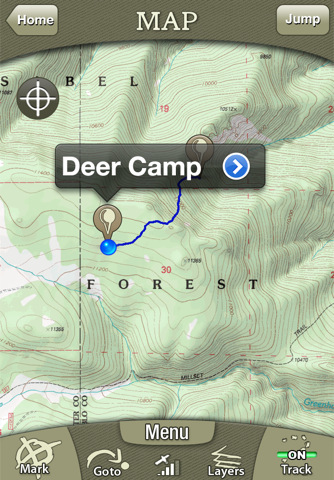
• Follow your track on seamless maps. Zoom in, zoom out. Know where you are at all times.
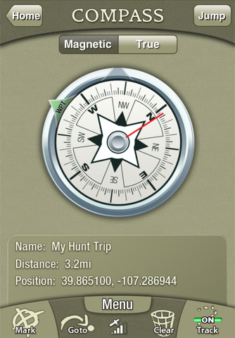
• Navigate with the digital compass. Choose between: Magnetic North and True North. (Note: Magnetic Compass only works on iPhone 3GS and 4)
• Use the Goto feature to navigate from your current location to a saved or manually entered coordinate.
COLLECT DATA
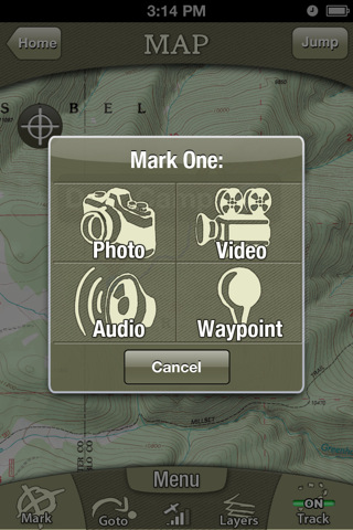
• Mark waypoints of your favorite (or secret) spots like a hunting blind, treestand, game trails or where you parked your truck.
• Record unlimited tracks. See where and how far you have traveled.
• Capture photos and videos (3GS and 4 only). The Recon Hunt app geotags your media to an exact location on a map.
• Record bugling elk, gobbling wild turkeys or other sounds with the audio recorder.
• See 15+ trip stats, including mileage, speed, elevation, direction, elevation gain/loss, and GPS position.
PLAN & PREPARE
• View Sun and Moon phases by date and location.
• Read the five-day weather forecast. See the current humidity, heat index, dew point, wind chill, wind speed and direction.
MADE FOR HUNTERS
• Get exclusive in-app deals and coupons from Cabela's.
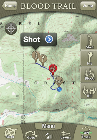
• Turn on Blood Trailing to track blood spots after the shot. Also, measure distances from shot location to hit and recovery spots.
• Disable beeps and noises in the app.
• See ballistics details and graphs for 200+ pistol and rifle cartridges.
• Save precious battery power. Recon Hunt carefully manages battery life based on how you use it.
• Enter the shooting range for your weapon and see the kill zone from your current location.
Notes: Continued use of GPS running in the background can dramatically decrease battery life. Recon Hunt is designed and optimized for the iPhone 4, 3GS, and 3G. The 1st generation models lack a GPS chip required to run the application.
What's New in This Release:
· Ability to purchase Mega Offline Maps.
· Track accuracy fixed in map screen.
· Miscellaneous bug fixes.
Like it? Share with your friends!
If you got an error while installing Themes, Software or Games, please, read FAQ.
Supported operating systems:
Apple iOS 10.x (iPad), Apple iOS 10.x (iPhone), Apple iOS 11.x (iPad), Apple iOS 12.x (iPad), Apple iOS 12.x (iPhone), Apple iOS 5.0 (iPad), Apple iOS 5.0 (iPhone), Apple iOS 5.0 (iPod Touch), Apple iOS 6.0 (iPad), Apple iOS 6.0 (iPhone), Apple iOS 6.0 (iPod Touch), Apple iOS 7.0 (iPad), Apple iOS 7.0 (iPhone), Apple iOS 7.0 (iPod Touch), Apple iOS 8.x (iPad), Apple iOS 8.x (iPhone), Apple iOS 8.x (iPod Touch), Apple iOS 9.x (iPad), Apple iOS 9.x (iPhone), Apple iOS 9.x (iPod Touch)
Similar Software:
Trapster (iPhone) Trapster is a free application that alerts you as you approach police speed traps, red light cameras or speed cameras. Also, it provides turn by turn directions, local search, and My Trips trip recorder all from within Trapster!
· World's most complete and up to date speed trap and camera database with 500,000 traps reported
Localscope Localscope is your social data powered GPS tool. Always know where you are and what’s around you with Localscope!
Search & discover places around you with information from multiple geo search engines & social networks: Google, Bing, Foursquare, Twitter, Wikimapia
Garmin StreetPilot Download Garmin StreetPilot and get Garmin award-winning navigation, similar to the premium features on Garmin’s renowned nüvi personal navigators. Designed exclusively for your iPhone or iPad, this mobile application turns your device into a GPS navigator with turn-by-turn voice-prompted directions and premium features for wherever you want to go
Garmin SG/MY Garmin SG/MY - Garmin StreetPilot is a powerful GPS navigation solution for iOS devices. It comes preloaded with the latest maps of Singapore, Malaysia and Brunei.
Garmin Street offers many useful features, such as turn-by-turn directions, photo-realistic junction views, 3D buildings, exit services, speed cameras, and more
Mobile Maps Gulf Countries GPS Navigation Mobile Maps Gulf Countries GPS Navigation - Sygic Mobile Maps is the most complete turn-by-turn, voice guided navigation software for your mobile phone.
· All maps with you on your phone - Bahrain, Kuwait, Oman, Qatar, Saudi Arabia and United Arab Emirates from TomTom.
· Free map updates.
· Speed camera crowd-sourcing protects your wallet
CoPilot Live USA CoPilot Live USA - CoPilot Live is one of the most highly acclaimed mobile GPS navigation applications available, widely recognized by the experts as the best blend of features and performance for an amazing price
Navmii GPS Live Ireland Navmii GPS Live Ireland - Navmii is a powerful GPS navigation solution for iOS devices. The app features turn-by-turn directions, voice guidance, automatic rerouting, live Google and Microsoft Bing Search, and more.
Navmii uses offline maps which are stored locally on the device, so there is no need for a data connection
Navfree GPS Live South Africa Navfree GPS Live South Africa - Navfree is a free GPS navigation solution for iOS devices. The app uses OpenStreetMap data, created and updated by thousands of users from all over the world.
The maps are stored locally on the device, so there is no need for a data connection
Durgapur World Travel Durgapur World Travel - Map with locate me function makes you free to move.
Background reading always accompanies you on your trip
Nav4D Balkan (LOW COST) Nav4D Balkan (LOW COST) - The first **low cost** application!
Don't waste your money!
Why pay for lifetime if you only need it for a limited time??
Nav4D is highly innovative at a very low price.
Nav4D is a high-end GPS navigator. It brings a new look to users mobility interaction. Turn by turn directions
Other Software by developer «Trimble Navigation Limited»:
Backpacker GPS Trails Lite Backpacker GPS Trails Lite - Record hiking trails, backpacking trips, and camping adventures with Backpacker GPS Trails Lite. View maps, navigate with GPS and digital compass, take photos, and backtrack to the trailhead. GPS Trails Lite works in remote places like national parks, wilderness areas, and backcountry spots without relying on data and cell signals
AllSport GPS LE (iPhone) AllSport GPS LE - Easy to use yet delivering power and outstanding value, AllSport GPS LE - a free version of the popular AllSport GPS fitness application - transforms your iPhone into a full-featured workout tracker and GPS-enabled trainer for road cycling, mountain biking, running, walking, and other sports and fitness activities
Geocache Navigator (Nokia) Provides hours of entertainment by combining the technology in your phone with one of the fastest-growing international hide and seek games - geocaching (also known as "GPS treasure hunt"). By using your phone's GPS and built-in Internet, Geocache Navigator creates a seamless and exciting experience
AllSport GPS (iPhone) AllSport GPS - Easier to use and delivering more value and power than ever, AllSport GPS transforms your iPhone into a full-featured workout tracker and GPS-enabled trainer for road cycling, mountain biking, running, walking, and other sports and fitness activities.
Tracking workouts on your iPhone is as easy as Start, Sweat, Stop
Cabela's Recon Hunt Cabela's Recon Hunt is the first mobile navigation application built solely for hunters. With Recon Hunt, you can find hunting spots on detailed maps, track wildlife, take trophy photos and backtrack home. Recon Hunt also tracks other essentials as well: weather forecasts, sun and moon phases, trip stats and ballistics information
Backpacker GPS Trails Backpacker brings the outdoors straight to the reader's doorstep, inspiring and enabling them to go more places and enjoy nature more often. The authority on active adventure, Backpacker is the world's first GPS-enabled magazine and website, and the only outdoor media whose editors and network of map contributors personally map the hiking trails they publish
AllSport GPS FREE Track workouts--runs, rides, walks & more. Map routes. Burn calories. Reach your fitness goals faster with AllSport GPS FREE. Track workouts--runs, walks, bike rides and other sports--on a map. View 25 heart-pounding stats as you sweat: time, speed, calories, distance

")


")


")

")
")
")


