Platforms: iPhone, iPad, iPod Touch, Apple iPhone OS
Categories: Travel & Navigation
Upload date: 27 Aug 11
Developer: Flytomap
License: Commercial
Price: 2.99 $
Downloads: 35
Cape Verde Islands - GPS Map Navigator - FlytoMap provides complete, quick and easy to use map applications for navigation for iPhone. Continues in the tradition of offering depth of information and functionality across expected places all over the world, exploring the map you get maximum details obtaining detailed information of every object on the map.
FlytoMap processes different types of maps for navigation for different categories:
WATER MAPS (Marine):
Water map navigator is the new ‘Marine Navigator for iPhone’ contains embedded Electronic Nautical Charts (ENC) from NOAA compressed to a large coverage. You can now download the application and transform your iPhone in a chart plotter with best NOAA, ENC S57 cartography; which includes Anchoring areas, Fishing areas, restriction areas, obstructions, rocks, Buoys, Beacons, Lights, Depth contours with Values display on map, Spot Soundings and more. The only marine app available in the market with such huge information. Every effort is made to be as accurate as possible when presenting information for every destination.
PARK MAPS:
Park map applications are extremely advanced contains embedded electronic charts with all information collected from the National Park Service and local sources. The maps contain all multiple trails (Hiking, biking, Stairway trails, Bicycle trails, Equestrian trails etc.,) and Point of interests (POI) like Campgrounds, Eating places, Ranger Stations, Picnic areas, Boat/Canoe launching, Parking areas etc., which are provided depending on the relevant park areas they exist.
LAKE MAPS:
We offer high quality lake maps with detailed information and important features compressed to assure the larger coverage in USA region. Lake maps contain most important DNR lakes with detailed ‘Depth Contours, Boat Ramps, Fishing spots etc. Also includes Trails, Roads and Railways information.
TRAVEL MAPS:
These Maps treat you mostly with information of both Marine and terrain correspondingly. These are the most preferable Maps to travel especially for fascinating recreational voyages, map focus the best Beach spots along the Coast line, Major ports, Sailing, Fishing, Picnic areas, Parks, Hiking, Biking, Clubs, restaurants, Famous Hotels, Museums, Shopping areas, and much more.
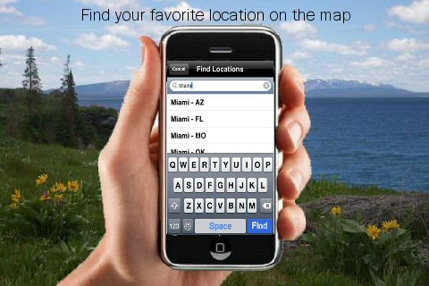
· Use Latitudes and Longitudes to go to your favorite places
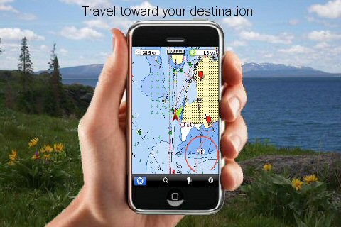
· Insert the target/destination 'Waypoint' and see in real time your speed, distance and direction to destination
· Insert Unlimited Markers near favorite places on the map
· Search your Favorite points directly
· Zoom, Rotate and Pan fast just by a finger touch
· Navigate and see your GPS position on the map
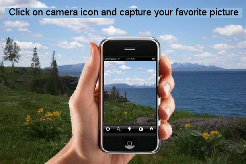
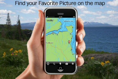
· Geo-Tagged photo management
· Set On/Off Elevation Contours if you feel data is cluttering
What's New in This Release:
· Minor bug fixed
· Retina display management
Like it? Share with your friends!
If you got an error while installing Themes, Software or Games, please, read FAQ.
Supported operating systems:
Apple iOS 10.x (iPad), Apple iOS 10.x (iPhone), Apple iOS 11.x (iPad), Apple iOS 12.x (iPad), Apple iOS 12.x (iPhone), Apple iOS 4.2.x (iPad), Apple iOS 4.2.x (iPhone), Apple iOS 4.2.x (iPod Touch), Apple iOS 4.3.x (iPad), Apple iOS 4.3.x (iPhone), Apple iOS 4.3.x (iPod Touch), Apple iOS 5.0 (iPad), Apple iOS 5.0 (iPhone), Apple iOS 5.0 (iPod Touch), Apple iOS 6.0 (iPad), Apple iOS 6.0 (iPhone), Apple iOS 6.0 (iPod Touch), Apple iOS 7.0 (iPad), Apple iOS 7.0 (iPhone), Apple iOS 7.0 (iPod Touch), Apple iOS 8.x (iPad), Apple iOS 8.x (iPhone), Apple iOS 8.x (iPod Touch), Apple iOS 9.x (iPad), Apple iOS 9.x (iPhone), Apple iOS 9.x (iPod Touch)
Similar Software:
CoPilot Live Premium Brasil CoPilot Live Premium Brasil is the full-featured voice-guided GPS navigation application that guides you where you need to go, in-car or on foot.
Detailed street maps of Brasil are stored on-board your iPhone so you don’t need to rely on your mobile connection for navigation.
CoPilot Live Premium puts you in control, with a choice of routes to your destination
Garmin China Garmin China - Garmin StreetPilot is a powerful GPS navigation solution for iOS devices. It comes preloaded with the latest maps of China, Hong Kong and Macau.
Garmin Street offers many useful features, such as turn-by-turn directions, photo-realistic junction views, 3D buildings, exit services, speed cameras, and more
Madagaskar - GPS Map Navigator Madagaskar - GPS Map Navigator - FlytoMap provides complete, quick and easy to use map applications for navigation for iPhone. Continues in the tradition of offering depth of information and functionality across expected places all over the world, exploring the map you get maximum details obtaining detailed information of every object on the map
Marine: UK-Ireland-Netherlands - GPS Map Navigator Marine: UK-Ireland-Netherlands - GPS Map Navigator - The FlyToMap App resembles a Chart plotter on your mobile device, to the Great Waterways of UK-Ireland-Netherlands providing value added map features and information for sailing signifying all the nautical standards for safe navigation
Toledo (OH, USA) Map Offline Toledo (OH, USA) Map Offline - This will be perfect when you are traveling and you don't have internet connection. This Offline Maps is not a replacement of Google Maps. It is used when you don't have internet connection and want to use maps
Cologne GPS Guide The only thing we do, help you to move freely as an alien, by "Offline" & "GPS"
GPS by TeleNav GPS by TeleNav - TeleNav GPS is your everyday GPS application that helps you decide where to go, how to get there, and what to do when you're there
Navmii GPS Live Netherlands Navmii GPS Live Netherlands - Navmii is a powerful GPS navigation solution for iOS devices. The app features turn-by-turn directions, voice guidance, automatic rerouting, live Google and Microsoft Bing Search, and more.
Navmii uses offline maps which are stored locally on the device, so there is no need for a data connection
Martha's Vineyard & Nantuket Island - GPS Map Navigator Martha's Vineyard & Nantuket Island - GPS Map Navigator - FlytoMap provides complete, quick and easy to use map applications for navigation for iPhone. Continues in the tradition of offering depth of information and functionality across expected places all over the world, exploring the map you get maximum details obtaining detailed information of every object on the map
CoPilot Live Nordics CoPilot Live Nordics - Welcome to CoPilot Live, the award-winning sat navigation app that runs on your iPhone to guide you door to door with complete street maps of Norway, Sweden, Denmark and Finland.
CoPilot Live is the personal travelling assistant who's always at your side, ready to guide you to the door with turn-by-turn voice directions
Other Software by developer «Flytomap»:
Grand Teton National Park - GPS Map Navigator Grand Teton National Park - GPS Map Navigator - Continues in the tradition of offering depth of information and functionality across expected places all over the world, exploring the map you get maximum details obtaining detailed information of each object on the map
Great Smoky Mountains National Park - GPS Map Navigator Great Smoky Mountains National Park - GPS Map Navigator - Continues in the tradition of offering depth of information and functionality across expected places all over the world, exploring the map you get maximum details obtaining detailed information of each object on the map
Cevennes National Park - GPS Map Navigator Cevennes National Park - GPS Map Navigator - FlytoMap provides complete, quick and easy to use map applications for navigation for iPhone. Continues in the tradition of offering depth of information and functionality across expected places all over the world, exploring the map you get maximum details obtaining detailed information of every object on the map
Agate Fossil Beds National Monument - GPS Map Navigator Agate Fossil Beds National Monument - GPS Map Navigator - Continues in the tradition of offering depth of information and functionality across expected places all over the world, exploring the map you get maximum details obtaining detailed information of each object on the map
Marine: (Huron-Erie-Ontario) HD - GPS Map Navigator Marine: (Huron-Erie-Ontario) HD - GPS Map Navigator - FlytoMap provides complete, quick and easy to use map applications for navigation for iPad. Continues in the tradition of offering depth of information and functionality across expected places all over the world, exploring the map you get maximum details obtaining detailed information of every object on the map
Malta - GPS Map Navigator Malta - GPS Map Navigator - FlytoMap provides complete, quick and easy to use map applications for navigation. Continues in the tradition of offering depth of information and functionality across expected places all over the world, exploring the map you get maximum details obtaining detailed information of every object on the map
Star Lake - Fishing Star Lake - Fishing - Continues in the tradition of offering depth of information and functionality across expected places all over the world, exploring the map you get maximum details obtaining detailed information of each object on the map
Madagaskar HD - GPS Map Navigator Madagaskar HD - GPS Map Navigator - FlytoMap provides complete, quick and easy to use map applications for navigation for iPad. Continues in the tradition of offering depth of information and functionality across expected places all over the world, exploring the map you get maximum details obtaining detailed information of every object on the map
Shawnee National Forest - GPS Map Navigator Shawnee National Forest - GPS Map Navigator - Continues in the tradition of offering depth of information and functionality across expected places all over the world, exploring the map you get maximum details obtaining detailed information of each object on the map
Duvenstedter Brook Nature Reserve - GPS Map Navigator Duvenstedter Brook Nature Reserve - GPS Map Navigator - The Duvenstedter Brook Nature Reserve is a vast spread of woodland, heath land, meadows and marshy areas Located in Hamburg's northerly suburbs, this is a true wildlife haven and full of indigenous animals and plants

")


 Map Offline")


 HD - GPS Map Navigator")


