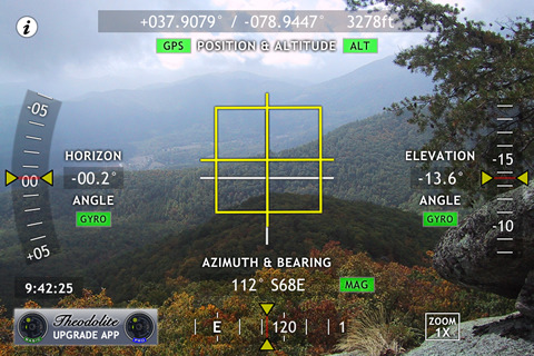
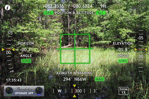
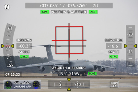
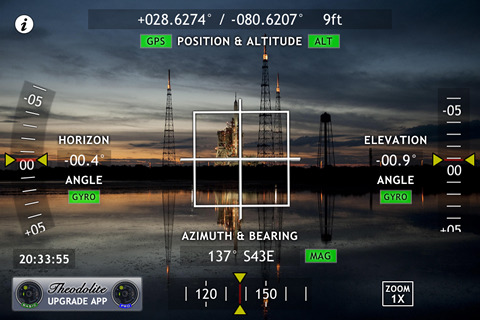
Theodolite Free Basedon a centuries-old astronomical instrument, Theodolite Free is a cool multi-function augmented reality app for the iPhone that serves as a compass, GPS, zoom scope, and two-axis inclinometer. Theodolite Free overlays real time information about position, altitude, bearing, and horizontal/vertical inclination on the iPhone’s live camera image, like an electronic viewfinder. Uses are endless, from land surveying to navigation, and the app is great for hiking, boating, hunting, golf, sports, sightseeing, and finding your way around.
Be sure to check out the more powerful Theodolite Basic and Theodolite Pro apps. Theodolite Basic lets you take camera images and screenshots directly from the app, with 2X and 4X digital zoom options. You can choose to stamp geographical data and custom notes directly on the saved image for later reference. View your current position on the built in map view, with standard, satellite, and hybrid modes. On an iPhone 3GS and 4, bearing is updated live on the map with both fixed view and world rotation. Theodolite Basic also has optical accelerometer/gyro calibration.
Theodolite Pro includes all "Basic" features, and adds a zero reference mode for angles and a handy "A-B" calculator to compute height of landmarks, distance to landmarks, triangulate position, compute distance/heading between points, show relative angles between observations, and show points on the map. Theodolite Pro also provides integration with the system-wide clipboard, e-mail data export with KML, mil compass readout, optical rangefinders (including a mil-based reticle), display of percent grade, and multiple position formats including MGRS and UTM.
Note: Theodolite works on any iPhone. GPS functionality requires an iPhone 3G, 3GS, or 4. Compass functionality requires an iPhone 3GS or 4. On iPhone 4, compass and inclinometer data are augmented by the gyro, and the application uses high res artwork for the Retina Display.
What's New in This Release:
· Revised to match version 2.6 of Pro and HD versions of the app.
What's New in 2.3.1:
· Revised settings interface and upgrade screens.
What's New in 2.2:
· Revised upgrade info for new geo-tagging feature in Basic and Pro versions. New icon artwork
Like it? Share with your friends!
If you got an error while installing Themes, Software or Games, please, read FAQ.
Supported operating systems:
Apple iOS 10.x (iPhone), Apple iOS 12.x (iPhone), Apple iOS 4.0.x (iPhone), Apple iOS 4.0.x (iPod Touch), Apple iOS 4.2.x (iPhone), Apple iOS 4.2.x (iPod Touch), Apple iOS 4.3.x (iPhone), Apple iOS 4.3.x (iPod Touch), Apple iOS 5.0 (iPhone), Apple iOS 5.0 (iPod Touch), Apple iOS 6.0 (iPhone), Apple iOS 6.0 (iPod Touch), Apple iOS 7.0 (iPhone), Apple iOS 7.0 (iPod Touch), Apple iOS 8.x (iPhone), Apple iOS 8.x (iPod Touch), Apple iOS 9.x (iPhone), Apple iOS 9.x (iPod Touch)
Similar Software:
Garmin UK & Ireland Garmin UK & Ireland - Download Garmin StreetPilot Onboard UK & Ireland and give your iPhone the best in GPS navigation... with free camera alerts, photoReal junction views, 3D buildings, and more
CoPilot Live Russia CoPilot Live Russia - Welcome to CoPilot Live, the multi-award winning turn-by-turn GPS navigation app with street maps of Russia.
CoPilot Live is your personal travelling assistant, always ready to guide you to the door with voice directions. It can also keep you better informed with useful live information about your route
TomTom Greece TomTom Greece - Get the TomTom navigation app and have smart, easy-to-use, turn-by-turn navigation on your iPhone or iPod touch, whenever and wherever you need it.
And, now, never miss a turn. The new TomTom app guides you even while you are on a call or running a different app on your iPhone
Green Mountain National Forest - GPS Map Navigator Green Mountain National Forest - GPS Map Navigator - Continues in the tradition of offering depth of information and functionality across expected places all over the world, exploring the map you get maximum details obtaining detailed information of each object on the map
Navfree GPS + Street View Spain Navfree GPS + Street View Spain - Navfree is a free GPS navigation solution for iOS devices. The app uses OpenStreetMap data, created and updated by thousands of users from all over the world.
The maps are stored locally on the device, so there is no need for a data connection
Sygic Argentina, Chile, Uruguay: GPS Navigation Sygic Argentina, Chile, Uruguay: GPS Navigation - Sygic is a premium turn-by-turn GPS navigation application. Sygic boasts an intuitive interface: drag the map, pinch to zoom, change point of view using built-in compass and tap target square to choose action
Bryce Canyon National Park - GPS Map Navigator Bryce Canyon National Park - GPS Map Navigator - Continues in the tradition of offering depth of information and functionality across expected places all over the world, exploring the map you get maximum details obtaining detailed information of each object on the map
Chemnitz (Germany) Maps Offline Chemnitz (Germany) Maps Offline - This will be perfect when you are traveling and you don't have internet connection. This Offline Maps is not a replacement of Google Maps. It is used when you don't have internet connection and want to use maps
CoPilot Live Premium Southern Africa (iPhone/iPad) CoPilot Live Premium Southern Africa (iPhone/iPad) - Welcome to CoPilot Live, the award-winning GPS navigation app that runs on your iPhone to guide you door to door throughout South Africa, Lesotho, Swaziland, Namibia and Botswana.
Detailed street maps are stored on your phone, not downloaded each trip, so there's no need for map downloads over the mobile internet
London GPS Guide The only thing we do, help you to move freely as an alien, by "Offline" & "GPS"
Other Software by developer «Hunter Research and Technology»:
Theodolite Basic Based on a centuries-old astronomical instrument, Theodolite Basic is a cool multi-function augmented reality app for the iPhone that serves as a compass, GPS, map, zoom camera, and two-axis inclinometer
Theodolite Pro Based on a centuries-old astronomical instrument, Theodolite is a cool multi-function augmented reality app for the iPhone that serves as a compass, GPS, map, zoom camera, rangefinder, and two-axis inclinometer
Butterfly Collection Butterfly Collection - Roam the world from your iPhone or iPod Touch to explore diverse species of butterflies and moths. Butterfly Collection showcases 240 members of the fascinating and beautiful order of insect known as Lepidoptera (ancient Greek for "scale wing"), using photographs of actual insects
greenMeter GreenMeter is an application for the iPhone and iPod Touch that computes your vehicle's power and fuel usage characteristics and evaluates your driving to increase efficiency, reduce fuel consumption and cost, and lower your environmental impact
gMeter gMeter is an application that turns the iPhone and iPod Touch into a vehicle performance computer. By using the onboard accelerometer in these devices, gMeter can measure forward and lateral g forces and use this data to compute acceleration, velocity, distance traveled, and engine power
gyroLens gyroLens - Ever have problems taking that perfect photo? Can't frame a straight shot? Need help getting a level image? Use gyroCam! This full-featured camera app has a killer new feature: it automatically levels photos in real time, while shooting
ODAT Tracker This application tracks deals from backcountry.com's "one deal at a time" (ODAT) sites
Theodolite Based on a centuries-old astronomical instrument, Theodolite is a cool multi-function augmented reality app for the iPhone that serves as a compass, GPS, map, zoom camera, rangefinder, and two-axis inclinometer
Wx for iPad Wx for iPad The venerable U.S. weather app Wx is now available for iPad! Wx displays current conditions, forecasts, alerts, and radar for U.S. locations using high fidelity XML data from the U.S. National Weather Service
gyroCam gyroCam Ever have problems taking that perfect photo? Can't frame a straight shot? Need help getting a level image? Use gyroCam! This full-featured camera app has a killer new feature: it automatically levels photos in real time, while shooting

")


 Maps Offline")
")


