Platforms: iPhone, iPad, iPod Touch, Apple iPhone OS
Categories: Travel & Navigation
Upload date: 15 Sep 11
Developer: EnGIS Communications, Inc.
License: Commercial
Price: 29.99 $
Downloads: 67
Gogo Navigator USA & CAN is a real-time, turn-by-turn 3D navigation app. It features real-3D, Text-To-Speech voice guidance, Advanced Lane Guidance, real Signpost display, millions of onboard POIs and much more.
· The most advanced, fully featured turn-by-turn navigation app available for the iPhone today!
· Find Places: millions of onboard POIs plus Google Local Search means you’ll always find what you’re looking for!
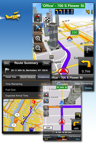
· Real 3D: stunning 3D landmarks fully textured and accelerated by latest cutting-edge OpenGL graphics technology
· Text-To-Speech (TTS) voice guidance
· Lane Guidance: shows you the correct lane to be in
· Realistic Signpost Display
· Map data from Tele Atlas onboard (offline maps): covers USA, Canada, Hawaii and Puerto Rico
· Free Gogo Navigator software updates
· Gogo brings over 12 years of navigation and digital mapping experience direct to your iPhone! NAVIGATION FEATURES:
· Turn-by-turn voice directions
· Real-3D
· Text-To-Speech (speaks street names)
· Real Signpost display
· Lane Guidance
· Auto re-routing
· Precise voice guidance with adjustable volume
· Multiple routing options; faster time, shorter distance
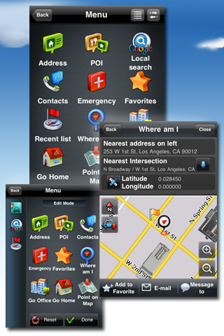
· Search by Address, Point on Map, ZIP and more
· Intelligent POI searching: search by phone number, Address, Category, POI name
· Advanced POI name searching: search by full name or partial word
· Ability to save and edit favorites
· Recent destinations stored
· Quick POI features (Home, Office, and Emergency POIs)
· Auto zooming (at intersection & on speed)
· Route Planning: create and save route itineraries
· Fuel cost calculator (customizable)
· Route summary for trip information
· Speed Limit warning: adjustable audio/visual warning
· Simulation control
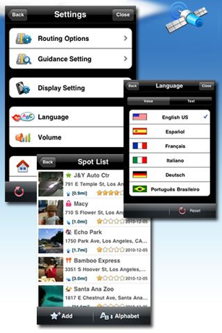
· Languages: US English, Latin Amer. Spanish, CA. French, Korean IPHONE FEATURES:
· Fully customizable main page and menu editing
· Automatic Landscape and Portrait rotation
· iPod Sound Control - Integrated Navigation Guidance while music is playing: you can choose to mute or fade music during guidance
· iPhone Contacts Integration: Route to your contacts.
· Phone call interruption. Gogo auto resumes after incoming phone call.
· iPhone standard touch gestures: scroll through the menus and list.
· Call POI function
· Multitasking control NAVIGATION SETTINGS:
· Automatic day/night mode: auto adjusts screen brightness based on local sunset and sunrise times.
· Multiple Day and Night modes
· Multiple vehicle symbols
· Control safety alerts
· Control POI individual category display
What's New in This Release:
Contacts:
· Enhanced contact matching function.
Guidance and Searching:
· Improved guidance and address searching.
General Application:
· Enhanced pedestrian mode function.
· Modified and improved the Favorite screen.
What's New in 1.2.0: Traffic:
· 'Live Traffic' is now available as in-app purchase. Traffic information is provided by Clear Channel Total Traffic Network. See in-app purchase or gogonavigator.com for further details.
Navigation Modes:
· Pedestrian Navigation mode added for city navigation by foot.
General Application:
· Quit button added on Main Menu screen (multitasking setting is now removed from Settings).
· Button Layout: you can set up Gogo Navigator for right-handed or left-handed operation.
· Upside down GUI applied. Users may now use Gogo app when placing the phone upside down. (Usage scenario example: when placing the phone in the cup holder, the in-car power plug can be placed facing upwards).
Contacts:
· Improvements for matching addresses from the 'iPhone Contacts' to the map database.
Display:
· Car symbol for the 3D Map has been moved farther up the screen to allow users to view current and previous street(s) more easily.
· Route information labels (Time & Distance values) at bottom of screen: Font size increased; Color codes added (gold for distance, blue for time and white for speed); You may now use any choice of distance and time information in either field option; Speed (current driving speed) added as display option; Label texts have been shortened to reduce space on screen; The 'second' value is removed from the ETA time.
· Speed limit icon is repositioned to top-right of screen.
· The scale bar is hidden automatically three seconds after the user zooms in or zooms out.
· Subsequent Turn Arrow (Route guidance mode) is now only shown when two manoeuvres are in close succession. This 2nd turn indicator is now synced with the voice 'then guidance'. E.g. Turn left, then Turn Right.
User Manual:
· User Manual available on website has been updated to explain changes.
What's New in 1.2.0:
Traffic:
· 'Live Traffic' is now available as in-app purchase. Traffic information is provided by Clear Channel Total Traffic Network. See in-app purchase or gogonavigator.com for further details.
Navigation Modes:
· Pedestrian Navigation mode added for city navigation by foot.
General Application:
· Quit button added on Main Menu screen (multitasking setting is now removed from Settings).
· Button Layout: you can set up Gogo Navigator for right-handed or left-handed operation.
· Upside down GUI applied. Users may now use Gogo app when placing the phone upside down. (Usage scenario example: when placing the phone in the cup holder, the in-car power plug can be placed facing upwards).
Contacts:
· Improvements for matching addresses from the 'iPhone Contacts' to the map database.
Display:
· Car symbol for the 3D Map has been moved farther up the screen to allow users to view current and previous street(s) more easily.
· Route information labels (Time & Distance values) at bottom of screen: Font size increased; Color codes added (gold for distance, blue for time and white for speed); You may now use any choice of distance and time information in either field option; Speed (current driving speed) added as display option; Label texts have been shortened to reduce space on screen; The 'second' value is removed from the ETA time.
· Speed limit icon is repositioned to top-right of screen.
· The scale bar is hidden automatically three seconds after the user zooms in or zooms out.
· Subsequent Turn Arrow (Route guidance mode) is now only shown when two manoeuvres are in close succession. This 2nd turn indicator is now synced with the voice 'then guidance'. E.g. Turn left, then Turn Right.
User Manual:
· User Manual available on website has been updated to explain changes.
What's New in 1.1.1:
Searching:
· POI Search – the result list now highlights the part-of-word that is searched for.
· Google Local Search – the town/city name is now included in the result list.
Display:
· Resolved a bug where the map heading changed to North-Up after using ‘Where Am I’ or ‘Route Summary’. It now correctly reverts to the previous map heading; i.e. Heading-Up, North-Up or 3D mode.
Contacts:
· An update to resolve some specific cases where contact addresses are not matched to the map database. Please note that further improvements are planned for contact address matching in the upcoming release version 1.2.0.
· Resolved a defect with full state name and zip code.
General:
· Modified the ‘caution screen’ behavior on app start-up. If the box is checked, the message will not reappear.
· Improved memory handling when routing is not taking place.
Like it? Share with your friends!
If you got an error while installing Themes, Software or Games, please, read FAQ.
Supported operating systems:
Apple iOS 10.x (iPad), Apple iOS 10.x (iPhone), Apple iOS 11.x (iPad), Apple iOS 12.x (iPad), Apple iOS 12.x (iPhone), Apple iOS 4.0.x (iPhone), Apple iOS 4.0.x (iPod Touch), Apple iOS 4.2.x (iPad), Apple iOS 4.2.x (iPhone), Apple iOS 4.2.x (iPod Touch), Apple iOS 4.3.x (iPad), Apple iOS 4.3.x (iPhone), Apple iOS 4.3.x (iPod Touch), Apple iOS 5.0 (iPad), Apple iOS 5.0 (iPhone), Apple iOS 5.0 (iPod Touch), Apple iOS 6.0 (iPad), Apple iOS 6.0 (iPhone), Apple iOS 6.0 (iPod Touch), Apple iOS 7.0 (iPad), Apple iOS 7.0 (iPhone), Apple iOS 7.0 (iPod Touch), Apple iOS 8.x (iPad), Apple iOS 8.x (iPhone), Apple iOS 8.x (iPod Touch), Apple iOS 9.x (iPad), Apple iOS 9.x (iPhone), Apple iOS 9.x (iPod Touch), Apple iPhone OS 3.1.x, Apple iPhone OS 3.1.x (iPod Touch), Apple iPhone OS 3.2.x (iPad)
Similar Software:
Marine: Chesapeake Bay - GPS Map Navigator Marine: Chesapeake Bay - GPS Map Navigator - Continues in the tradition of offering depth of information and functionality across expected places all over the world, exploring the map you get maximum details obtaining detailed information of each object on the map
Kitzbuhel and Zillertal Ski Area Kitzbuhel and Zillertal Ski Area - Lets you find all streets, and many useful locations such as ATM's, parkings, museums, and many others. Remembers where you've been so you can find that parking spot where you left your rental car
Channel Islands National Park - GPS Map Navigator Channel Islands National Park - GPS Map Navigator - Continues in the tradition of offering depth of information and functionality across expected places all over the world, exploring the map you get maximum details obtaining detailed information of each object on the map
Jakarta Street Map Lite Jakarta Street Map Lite - Lets you find all streets, and many useful locations such as ATM's, parkings, museums, and many others. Remembers where you've been so you can find that parking spot where you left your rental car
Cambridge Walking Tours and Map This application presents you several self-guided walking tours to see the best of the city, and it comes with detailed tour route maps and powerful navigation features to guide you from one sight to the next
Europe - Offline map with directU Europe - Offline map with directU - This app is a free map viewer for iOS devices. It also provides basic navigation features, such as compass and trip computer.
The software uses offline maps provided by OpenStreetMap. The maps are stored locally on the device, so you don't have to worry about losing your internet connection, and you avoid unnecessary data traffic costs
Aberdeen Street Map Aberdeen Street Map - Lets you find all streets, and many useful locations such as ATM's, parkings, museums, and many others. Remembers where you've been so you can find that parking spot where you left your rental car
Dresden (Germany) Maps Offline Dresden (Germany) Maps Offline - This will be perfect when you are traveling and you don't have internet connection. This Offline Maps is not a replacement of Google Maps. It is used when you don't have internet connection and want to use maps
Prague Offline Streetmap Prague Offline Streetmap - You don't need to have internet connection for this to work as the map is stored on your iPhone or iPod Touch. Ideal for saving roaming charges or having to find the local wifi to access the built-in map application.
What's New in This Release:
· iOS 5 compatibility changes.
· Further bug fixes and improvements
Dresden Offline Street Map Dresden Offline Street Map - You don't need to have internet connection for this to work as the map is stored on your iPhone or iPod Touch. Ideal for saving roaming charges or having to find the local wifi to access the built-in map application.
What's New in This Release:
· iOS 5 compatibility changes.
· Further bug fixes and improvements
Other Software by developer «EnGIS Communications, Inc.»:
Gogo Navigator - JAPAN Gogo Navigator Japan is a turn-by-turn 3D navigation software for iPhone and iPod touch users in Japan. Gogo Navigator is your personal travel assistant ready to guide you to your destination. This amazing navigation application has been designed and optimized specially for the iPhone with simplicity and user experience in mind

")


 Maps Offline")


