Platforms: iPhone, iPad, iPod Touch, Apple iPhone OS
Categories: Travel & Navigation
Upload date: 12 Jul 13
Developer: Visual IT
License: Commercial
Price: 2.99 $
Downloads: 23
Tyne & Wear Metro by Zuti - The new Tyne & Wear Metro map makes it easy to travel in and around the city using the Nexus Metro system. Unlike old fashioned schematic style maps this product contains a geographically accurate central area showing major streets, parks and places of interest etc, allowing the user to easily get their bearings.
MAP
The map is hand drawn by Visual IT and provides a unique geographically based view of Tyne & Wear with many places of interest drawn directly on the background so you can easily get your bearings when traveling around the city. You can also use your inbuilt GPS to accurately locate and track yourself within the city centre and see the nearest transportation stop and distance to it. This is the only public transportation route planner with this ability.
Tap on the map for location information, use the inbuilt search feature or choose from a list of locations. Places of interest, museums, hotels, parks, restaurant, shops, hospitals, streets, etc, are also included. The route planner will automatically suggest the nearest station to any place of interest you select.
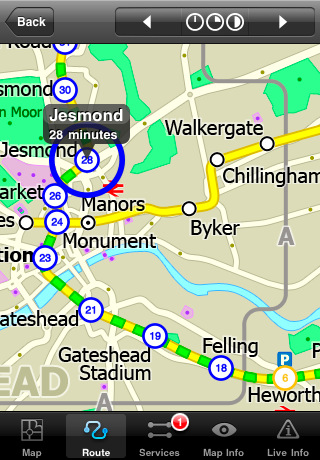
MINUTE MAP
Another great feature is the “Minute Map” option which allows you to see the travel times from a start point to all other locations on the map. This is a unique way to view the topology of a city and gauge traveling times.
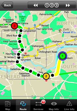
ROUTING
The application does not require an internet connection and will always be available to display a clear and detailed view of the city transport systems, plus list and animate the optimum route for your journey. This product provides the fastest route calculations of any mobile routing application (virtually instantaneous) using actual published journey times with the ability to select the quickest route or the route with the least changes.
LIVE INFO
When an internet connection is available, optional "Live Information" on the current state of the transport services can be viewed, allowing you to plan your journeys in advance and avoid any potential delays.
· Full offline map and routing, no internet connection required.
· Colourful clear custom drawn geographically accurate mapping.
· Animates the route and allows tracking of the journey using GPS
· Instantly see the route of any transport service drawn on the map.
· Save and recall favourite and recent journeys.
· Take me home feature.
· Unique "Minute Map" feature allows quick view of all journey times from a start location.
· Services can be turned on or off, routing round problems.
· Works on iPhone or iPod and in landscape or portrait mode.
· GPS location and tracking.
· Streets, Places of interest etc built into the application.
· Access to live service information.
What's New in This Release:
· New updated map
· New features
· Improved user interface
Like it? Share with your friends!
If you got an error while installing Themes, Software or Games, please, read FAQ.
Supported operating systems:
Apple iOS 10.x (iPad), Apple iOS 10.x (iPhone), Apple iOS 11.x (iPad), Apple iOS 12.x (iPad), Apple iOS 12.x (iPhone), Apple iOS 4.0.x (iPhone), Apple iOS 4.0.x (iPod Touch), Apple iOS 4.2.x (iPad), Apple iOS 4.2.x (iPhone), Apple iOS 4.2.x (iPod Touch), Apple iOS 4.3.x (iPad), Apple iOS 4.3.x (iPhone), Apple iOS 4.3.x (iPod Touch), Apple iOS 5.0 (iPad), Apple iOS 5.0 (iPhone), Apple iOS 5.0 (iPod Touch), Apple iOS 6.0 (iPad), Apple iOS 6.0 (iPhone), Apple iOS 6.0 (iPod Touch), Apple iOS 7.0 (iPad), Apple iOS 7.0 (iPhone), Apple iOS 7.0 (iPod Touch), Apple iOS 8.x (iPad), Apple iOS 8.x (iPhone), Apple iOS 8.x (iPod Touch), Apple iOS 9.x (iPad), Apple iOS 9.x (iPhone), Apple iOS 9.x (iPod Touch), Apple iPhone OS 3.1.x, Apple iPhone OS 3.1.x (iPod Touch), Apple iPhone OS 3.2.x (iPad)
Similar Software:
priceline Hotel & Car Negotiator priceline Hotel & Car Negotiator - Power up priceline.com's Hotel Negotiator app and let the Priceline Negotiator, William Shatner, find you last-minute Name Your Own Price hotel rooms that you can book at savings of up to 50%.
· Choose a city and see multiple winning hotel bids for the hotel star levels and parts of the city you want
Charlotte(North Carolina) World Travel Charlotte(North Carolina) World Travel - Map with locate me function makes you free to move.
Background reading always accompanies you on your trip
Tuscany for Foodies Tuscany for Foodies - Tuscany for Foodies introduces you to the best of foodie Tuscany, from the butchers, bakers, and cheese makers who adhere to ancient traditions and proudly sell their goods in small shops, to restaurants large and small that process local ingredients into good-to-eat meals
Lufthansa for iPhone Lufthansa for iPhone - The Lufthansa app turns your iPhone into a handy travel assistant.
With it, you can book Lufthansa flights from your mobile, check flight status, view the timetable and check in.
In addition, the application allows you to quickly access your personal travel details and your Miles & More account
Viva Las Vegas, Baby! Viva Las Vegas, Baby! - Don't waste a single second of your next escape to Las Vegas. Get under the skin of the city right now, from the neon-lit Strip to downtown's Fremont Street and beyond
London Bus London Bus - The new Zuti London Bus map has finally arrived, making it easy to travel by bus anywhere in central London. This clear and colourful map covers a detailed street level area of 6 miles by 4 miles and includes over 1300 bus stops and 189 bus routes
Plane Finder 3D for iPhone/iPad Plane Finder 3D for iPhone/iPad - Plane Finder 3D is a flight tracker that shows live air traffic in beautiful 3D.
With simple touch controls you can pan and zoom to fly around the planes, and can even get on board a plane for a captain's eye view from the cockpit
Free & Frugal Paris Free & Frugal Paris - There is no need to spend your life savings to enjoy Paris. Visiting Notre Dame? Skip the overpriced tourist cafes and picnic by the Seine. Interested in Parisian history? Visit the gorgeous Musee Carnavalet - it's free
iBART Live iBART Live From the makers of the acclaimed iBART, iBART Live is an intelligent transit application for Bay Area Rapid Transit. It is essential to all BART riders — from the occasional to the daily, the tourist to the commuter
Eat Manhattan Eat Manhattan - Eight million New Yorkers need somewhere to eat. So do the nearly 50 million tourists that visit the city every year. As a result, Manhattan is home to thousands of dining options. The only problem: one false move and lunch means a day-old hot dog rescued from a vat of murky water
Other Software by developer «Visual IT»:
Digital Camera Guide (UIQ) Digital Camera Guide (UIQ) - An essential guide for anyone new to the world of digital photography. In a simple easy to read format with superb photographs it helps you to get the most from your camera and explains how many of the complicated features of your camera work.
Index of subjects covered:
- Camera Controls
London Visitors A-Z London Visitors A-Z - The London Visitors Map of central London is designed especially for the tourist. The principal feature of the mapping is the highlighting of places of interest, buildings open to the public, theatres, cinemas, selected shops and stores, main shopping streets, main line and underground railway stations and other locations of interest to the visitor
Tube San Francisco (Series 60) Tube San Francisco (Series 60) - Our highly acclaimed Tube application that guides you around the BART system of San Francisco is now available for your Series 60 Symbian powered phone. An essential addition to your phone for locals and tourists alike.
· A detailed clear colour map of the San Francisco BART system fully scrollable
Tube 2 Paris (Palm OS) Tube 2 Paris (Palm OS) - This map package for Tube 2 consists of a fully scrollable detailed map of the Paris metro and RER system.
Plan journeys on this system, list details of the quickest routes and see a superb animated display of your journey tracking around the system map.
A Pro version is also available with integrated high quality street maps of central Paris
Tube 2 Hong Kong (UIQ3) Tube 2 Hong Kong (UIQ3) - This map package for Tube 2 consists of a fully scrollable detailed map of the Hong Kong metro & rail system.
Plan journeys on this system, list details of the quickest routes and see a superb animated display of your journey tracking around the system map
Tube 2 Barcelona Pro (Palm OS) Tube 2 Barcelona Pro (Palm OS) - This map package for Tube 2 consists of a fully scrollable detailed map of the Barcelona metro & rail system and linked street maps of central Barcelona.
Plan journeys on the metro system, list details of the quickest routes and see a superb animated display of your journey tracking around the system map
Tube 2 Hong Kong (Palm OS) Tube 2 Hong Kong (Palm OS) - This map package for Tube 2 consists of a fully scrollable detailed map of the Hong Kong metro & rail system.
Plan journeys on this system, list details of the quickest routes and see a superb animated display of your journey tracking around the system map
Tube 2 Milan (UIQ3) Tube 2 Milan (UIQ3) - This map package for Tube 2 consists of a fully scrollable detailed map of the Milan metro & rail system.
Plan journeys on this system, list details of the quickest routes and see a superb animated display of your journey tracking around the system map
Tube 2 San Francisco (Palm OS) Tube 2 San Francisco (Palm OS) - This map package for Tube 2 consists of a fully scrollable detailed map of the San Francisco metro & rail systems.
The maps in this package cover the BART, SCVTA & Caltrain systems plus the Municipal Metro, Municipal Historic Street Car and Cable Car systems in central SF
Tokyo Metro for iPad by Zuti Tokyo Metro for iPad by Zuti - Tokyo Metro map makes it easy to travel in and around the city using the Toei Subway, JR East routes (within the Tokyo Suburban area), Shinkansen routes, Streetcars, some important private lines and Tokyo Cruise lines

")


 World Travel")


")

")
")
")
")
")
")
")
