Platforms: iPhone, iPad, iPod Touch, Apple iPhone OS
Categories: Travel & Navigation
Upload date: 17 Sep 14
Developer: Garmin
License: Freeware
Downloads: 329
BaseCamp Mobile - BaseCamp Mobile is a companion app for the Garmin fenix GPS watch. It allows you to wirelessly download data from your watch to the iPhone.
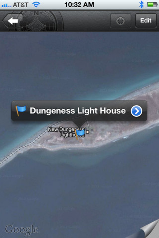
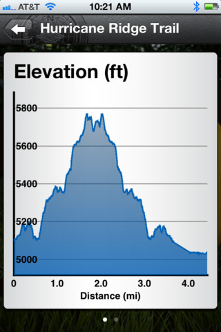
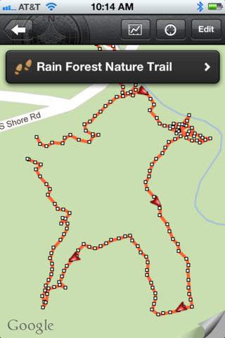
Downloaded data can be used to view routes and tracks on a map. Very useful for recording and reviewing your outdoor activities.
· Easy to use
· View routes and tracks on a map
· No need to buy additional maps
What's New in This Release:
· Added support for searching and viewing Garmin Adventures.
· Added support for sharing Adventures, GPX data (tracks, waypoints, etc.), and photos
· New look for iOS7.
What's New in 2.0:
· Cloud support
· Oregon 600 support
· Fixed reported app crashes
· Other miscellaneous fixes
Like it? Share with your friends!
If you got an error while installing Themes, Software or Games, please, read FAQ.
Supported operating systems:
Apple iOS 10.x (iPad), Apple iOS 10.x (iPhone), Apple iOS 11.x (iPad), Apple iOS 12.x (iPad), Apple iOS 12.x (iPhone), Apple iOS 6.0 (iPad), Apple iOS 6.0 (iPhone), Apple iOS 6.0 (iPod Touch), Apple iOS 7.0 (iPad), Apple iOS 7.0 (iPhone), Apple iOS 7.0 (iPod Touch), Apple iOS 8.x (iPad), Apple iOS 8.x (iPhone), Apple iOS 8.x (iPod Touch), Apple iOS 9.x (iPad), Apple iOS 9.x (iPhone), Apple iOS 9.x (iPod Touch)
Similar Software:
Mammoth Cave National Park - GPS Map Navigator Mammoth Cave National Park - GPS Map Navigator - Continues in the tradition of offering depth of information and functionality across expected places all over the world, exploring the map you get maximum details obtaining detailed information of each object on the map
NAVIGON MobileNavigator Canada NAVIGON MobileNavigator Canada - With the NAVIGON MobileNavigator you can transform your iPhone into a fully functional mobile navigation system that is every bit as good as the multi-award-winning personal navigation devices from NAVIGON in terms of its user-friendliness and features
Lakes: Texas Lakes: Texas - Continues in the tradition of offering depth of information and functionality across expected places all over the world, exploring the map you get maximum details obtaining detailed information of each object on the map
Red Panic Button (iPhone/iPad) Red Panic Button (iPhone/iPad) - When you are in trouble press the Red Panic Button! You just have to set a panic number or mail address and the mobile phone will send a message which contains your address and location, determined using the fine GPS based or coarse GSM based coordinates
CoPilot Truck HD - USA & Canada CoPilot Truck HD - USA & Canada - Introducing CoPilot Truck HD—the first iPad app that provides full-featured voice-guided GPS navigation designed specifically for professional drivers of trucks
Yonkers - New Rochelle (NY) Maps Offline Yonkers - New Rochelle (NY) Maps Offline - This will be perfect when you are traveling and you don't have internet connection. This Offline Maps is not a replacement of Google Maps. It is used when you don't have internet connection and want to use maps
NAVIGON U.S. Central for iPhone/iPad 2. With NAVIGON MyRegion you can transform your iPhone into a fully functional mobile navigation system that is every bit as good as the multi-award-winning personal navigation devices from NAVIGON in terms of its user-friendliness and features
Navfree GPS Live Italy Navfree GPS Live Italy - Navfree is a free GPS navigation solution for iOS devices. The app uses OpenStreetMap data, created and updated by thousands of users from all over the world.
The maps are stored locally on the device, so there is no need for a data connection
Saint Martin - GPS Map Navigator Saint Martin - GPS Map Navigator - FlytoMap provides complete, quick and easy to use map applications for navigation for iPhone. Continues in the tradition of offering depth of information and functionality across expected places all over the world, exploring the map you get maximum details obtaining detailed information of every object on the map
White Mountain National Forest - GPS Map Navigator White Mountain National Forest - GPS Map Navigator - Continues in the tradition of offering depth of information and functionality across expected places all over the world, exploring the map you get maximum details obtaining detailed information of each object on the map
Other Software by developer «Garmin»:
Garmin StreetPilot onDemand Garmin StreetPilot onDemand brings the power of Garmin navigation to your iPhone with rich navigation features for walking or driving, a simple and intuitive user interface, and an amazingly low price. Using your data connection, StreetPilot onDemand always has access to the most up-to-date maps for the U.S
Garmin Tracker (Android) Garmin Tracker (Android) - Brought to you by the worldwide leader in GPS, Garmin Tracker — combined with a GPS-enabled Garmin tracking device (purchase required) — lets you track what’s important while on the go.
Garmin Tracker is a free, unique application that will help keep tabs on whatever is important to you
Garmin GDL 39 Utility Garmin GDL 39 Utility - Garmin GDL 39 Utility is a companion app for the GDL 39 Portable ADS-B Receiver. It allows you to update your GDL 39 firmware using your iOS device.
The application also shows the signal strength, ground station status and battery life of GDL 39. In addition, it includes a navigation panel, which displays altimeter, heading and ground speed
Garmin China Garmin China - Garmin StreetPilot is a powerful GPS navigation solution for iOS devices. It comes preloaded with the latest maps of China, Hong Kong and Macau.
Garmin Street offers many useful features, such as turn-by-turn directions, photo-realistic junction views, 3D buildings, exit services, speed cameras, and more
Garmin Taiwan Garmin Taiwan - Garmin StreetPilot is a powerful GPS navigation solution for iOS devices. It comes preloaded with the latest map of Taiwan, including over 250,000 points of interest.
Garmin Street offers many useful features, such as turn-by-turn directions, photo-realistic junction views, 3D buildings, exit services, speed cameras, and more
Garmin UK & Ireland Garmin UK & Ireland - Download Garmin StreetPilot Onboard UK & Ireland and give your iPhone the best in GPS navigation... with free camera alerts, photoReal junction views, 3D buildings, and more
Garmin SG/MY Garmin SG/MY - Garmin StreetPilot is a powerful GPS navigation solution for iOS devices. It comes preloaded with the latest maps of Singapore, Malaysia and Brunei.
Garmin Street offers many useful features, such as turn-by-turn directions, photo-realistic junction views, 3D buildings, exit services, speed cameras, and more
OpenCaching (Android) OpenCaching (Android) is the official geocaching app for OpenCaching.com, a geocaching community powered by the user, for the user. With this app, you get the full OpenCaching.com experience right in the palm of your hands. Easily find, hide, log and share caches right from your Android device
Garmin GTN Trainer Garmin GTN Trainer - The Garmin GTN 750 Trainer allows you to experience the pilot interface and provide an on-the-ground environment to learn the basic operation of the avionics
Garmin GTN Trainer Garmin GTN Trainer - The Garmin GTN 750 Trainer allows you to experience the pilot interface and provide an on-the-ground environment to learn the basic operation of the avionics

")


")

 Maps Offline")


")

