Platforms: iPhone, iPad, iPod Touch, Apple iPhone OS
Categories: Travel & Navigation
Upload date: 26 Nov 11
Developer: Visual IT
License: Freeware
Downloads: 81
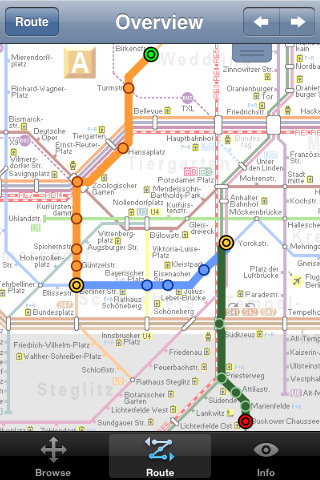
Berlin Metro 09 - The "Berlin Metro 09" application is a superb interactive map and route planner for the Berlin Metro (U-Bahn) and Suburban rail (S Bahn) systems. You can also use your inbuilt GPS (will also work with iPod Touch devices) to accurately locate and see the nearest transportation stop and distance to it. This application is one in a worldwide series of "Tube" maps from Visual IT who have been producing public transportation maps for mobile devices for many years.
SPONSORSHIP
This product is brought to you free of charge through the sponsorship of the Berlin transport authority VBB (Verkehrsverbund Berlin-Brandenburg).
MAP
Tap on the map for station information, use the inbuilt search feature or choose from a list of locations. Places of interest, museums, parks, shops, universities, theatres, etc, are also included. The route planner will automatically suggest the nearest station to any place of interest you select.
INTERNET CONNECTION
The map and routing does not require an internet connection and you will not be charged data connection fees. This also means the application runs successfully underground and on an iPod Touch. The only feature that requires an internet data connection is the “Live Info” which is optional and if used only requires a small amount of data.
ROUTING
Does not require an internet connection and will always be available to display a clear and detailed view of the city transport systems, plus list and animate the optimum route for your journey. Provides the fastest route calculations of any mobile routing application (virtually instantaneous) using actual published journey times with the ability to select the quickest route or the route with the fewest changes.
Comprehensive details of your planned route are provided, including changes, directions of travel, number of stops, predicted journey times, etc. Uniquely this application gives you “direction”, “towards” and “service frequency” information (not available on any other offline journey planner) for example “Take the U2 line (Southbound) towards Kaiserdamm for 4 stops. Service runs every 7 minutes” which is essential when finding the correct platform and connection. Also given are alternatives for each leg of the journey.
Like it? Share with your friends!
If you got an error while installing Themes, Software or Games, please, read FAQ.
Supported operating systems:
Apple iOS 10.x (iPad), Apple iOS 10.x (iPhone), Apple iOS 11.x (iPad), Apple iOS 12.x (iPad), Apple iOS 12.x (iPhone), Apple iOS 4.0.x (iPhone), Apple iOS 4.0.x (iPod Touch), Apple iOS 4.2.x (iPad), Apple iOS 4.2.x (iPhone), Apple iOS 4.2.x (iPod Touch), Apple iOS 4.3.x (iPad), Apple iOS 4.3.x (iPhone), Apple iOS 4.3.x (iPod Touch), Apple iOS 5.0 (iPad), Apple iOS 5.0 (iPhone), Apple iOS 5.0 (iPod Touch), Apple iOS 6.0 (iPad), Apple iOS 6.0 (iPhone), Apple iOS 6.0 (iPod Touch), Apple iOS 7.0 (iPad), Apple iOS 7.0 (iPhone), Apple iOS 7.0 (iPod Touch), Apple iOS 8.x (iPad), Apple iOS 8.x (iPhone), Apple iOS 8.x (iPod Touch), Apple iOS 9.x (iPad), Apple iOS 9.x (iPhone), Apple iOS 9.x (iPod Touch), Apple iPhone OS 2.x, Apple iPhone OS 2.x (iPod Touch), Apple iPhone OS 3.1.x, Apple iPhone OS 3.1.x (iPod Touch), Apple iPhone OS 3.2.x (iPad)
Similar Software:
London Tube by Zuti London Tube by Zuti - "London Tube 10" is a superb geographically based map and route planner for the London Underground, Overground, Docklands Light Railway (DLR), Croydon Tramlink and London Airport Express services. This is one in a worldwide series of Zuti maps from Visual IT who have been producing public transportation maps for mobile devices for many years
FlightTrack Pro FlightTrack Pro - the best flight tracking app out there. Get push alerts, real-time flight itinerary updates, automatic synching, and beautiful, zoomable maps that work offline. Flight cancelled? It will even help you find alternate flights.
FlightTrack Pro works seamlessly with TripIt. Forward your airline confirmation emails to plans@tripit
Vienna Metro by Zuti Vienna Metro by Zuti - This Zuti application contains a visually unique map of Vienna's transport systems and a superb animated journey planner to help you get around the Metro (U-Bahn), Suburban Rail (S-Bahn) and Tram (Stragenbahn)
Tucson & the Old Southwest Tucson & the Old Southwest - Indian lands, Spanish colony, Mexican outpost, wild western American territory and finally the State of Arizona - the history of the lands surrounding the 'Old Pueblo' makes for fascinating diversity and exciting exploration. Saguaro-studded desert to riverine canyons to pine-topped mountains - the geography is equally as diverse
INDIA ATLAS & TRAVEL SEARCH ENGINE INDIA ATLAS & TRAVEL SEARCH ENGINE - INDIA ATLAS & TRAVEL SEARCH ENGINE
· Trip planning tool.
· GPS Companion.
· ZOOM TOUCH capability with 2-fingers.
· RE-CENTER TOUCH capability with 1-finger.
· Portrait or landscape views.
· Take a picture of your screen.
· Then print or e-mail regularly as desired
Tokyo City Maps Tokyo City Maps - software that helps you download and store the travel maps and plans you need. This super-handy app lets you download publicly available maps and store them on your iPhone or iPod Touch. You can download the maps when you have fast wifi connection - and then use any time in the future without delay
Trip Journal Free (iPhone) Trip Journal is the #1 Travel Application with the best trip tracking, recording, documenting and sharing features currently available for the iPhone.
Trip Journal allows you to document vacation experiences and share them with your friends and family
Minneapolis Maps Minneapolis Maps - Software that helps you download and store the travel maps and plans you need. This super-handy app lets you download publicly available maps and store them on your iPhone or iPod Touch. You can download the maps when you have fast wifi connection - and then use any time in the future without delay
thetrainline thetrainline is the UK's leading independent train ticket retailer. We sell tickets for all train companies to all national destinations.
This is the official application from thetrainline and is perfect for anyone who wants to view UK train times or buy tickets on the move
Chicago Maps Chicago Maps - This super-handy app lets you download publicly available maps and store them on your iPhone or iPod Touch. You can download the maps when you have fast wifi connection - and then use any time in the future without delay. Transit Train and Street maps, as well as tourist guides to help you around the city
Other Software by developer «Visual IT»:
London Visitors A-Z for iPad London Visitors A-Z for iPad - The London Visitors A-Z map of central London is designed especially for the tourist
Rough Guides Map Dublin Rough Guides Map Dublin... These guides are a series of fantastic interactive maps.
Produced in conjunction with the premier travel publisher Rough Guides.
Discover and explore Dublin using full colour interactive linked maps, in this simple to use PDA version of The Rough Guides Dublin
Tube 2 London Geo (Palm OS) Tube 2 London Geo (Palm OS) - This superb map package for Tube 2 is the ideal map for anyone who needs to get around London using the underground system and would like to know just exactly where they are.
The map geographically accurately locates the central London stations, overlaid onto a street map. Now you can easily see how these stations fit into the real world
Washington Metro by Zuti Washington Metro by Zuti - The new Washington Metro 10 map makes it easy to travel in and around the city using the WMATA Metro, MARC and VME systems. Also included are the Potomac river taxi routes and the DC Circulator bus routes
Tube 2 Paris Touristic (UIQ3) Tube 2 Paris Touristic (UIQ3) - This map package for Tube 2 is the ideal map for the tourist or business traveller who needs to get around Paris using the metro system and would like to know just exactly where they are. The map geographically locates all the central stations, making it much more informative than the official topological map
Tube 2 Seoul (UIQ) Tube 2 Seoul (UIQ) - This map package for Tube 2 consists of a fully scrollable detailed map of the Seoul Metropolitan Subway system.
Plan journeys on this system, list details of the quickest routes and see a superb animated display of your journey tracking around the system map
Tube 2 Portland (UIQ) Tube 2 Portland (UIQ) - This map package for Tube 2 consists of a fully scrollable detailed map of the Portland rail system.
Plan journeys on this system, list details of the quickest routes and see a superb animated display of your journey tracking around the system map
London Visitors A-Z London Visitors A-Z - The London Visitors Map of central London is designed especially for the tourist. The principal feature of the mapping is the highlighting of places of interest, buildings open to the public, theatres, cinemas, selected shops and stores, main shopping streets, main line and underground railway stations and other locations of interest to the visitor
Simple SMS for Windows Mobile 5/6 Simple SMS for Windows Mobile 5/6 -This is our extremely popular SMS application for the Pocket PC.
Simple SMS enables you to write, send, receive and store SMS messages on your Pocket PC by connecting to your mobile phone via Bluetooth, Infra red or Cable
Tube Seoul (Series 60) Tube Seoul (Series 60) - Our highly acclaimed Tube application that guides you around the complex subway system of Seoul is now available for your Series 60 Symbian powered phone. An essential addition to your phone for locals and tourists alike.
· A detailed clear colour map of the Seoul subway system fully scrollable.
· Quick find station utility

")


")


")

")
")
")


")