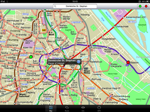
Vienna Metro 10 - The new Zuti Vienna Metro map makes it easy to travel in and around the city using the Metro (U-Bahn), Suburban Rail (S-Bahn) or Tram (Straßenbahn) systems. Unlike old fashioned schematic style maps this product contains a geographically accurate central area showing major streets, parks and places of interest etc, allowing the user to easily get their bearings.
MAP
The map is hand drawn by Visual IT and provides a unique geographically based view of Vienna with many places of interest drawn directly on the background so you can easily get your bearings when traveling around the city. You can also use your inbuilt GPS to accurately locate and track yourself within the city centre and see the nearest transportation stop and distance to it. This is the only pubic transportation route planner with this ability.
Tap on the map for location information, use the inbuilt search feature or choose from a list of locations. Places of interest, museums, hotels, parks, restaurant, shops, hospitals, streets, etc, are also included. The route planner will automatically suggest the nearest station to any place of interest you select.
MINUTE MAP
Another great feature is the “Minute Map” option which allows you to see the travel times from a start point to all other locations on the map. This is a unique way to view the topology of a city and gauge traveling times.
ROUTING
The application does not require an internet connection and will always be available to display a clear and detailed view of the city transport systems, plus list and animate the optimum route for your journey. This product provides the fastest route calculations of any mobile routing application (virtually instantaneous) using actual published journey times with the ability to select the quickest route or the route with the least changes.
What's New in This Release:
· Improved user interface.
· Save and recall favourite routes.
· Instant Minute Map from any tap location.
· Show any transport service drawn on the map.
· Minor map updates.
Like it? Share with your friends!
If you got an error while installing Themes, Software or Games, please, read FAQ.
Supported operating systems:
Apple iOS 10.x (iPad), Apple iOS 11.x (iPad), Apple iOS 12.x (iPad), Apple iOS 4.2.x (iPad), Apple iOS 4.3.x (iPad), Apple iOS 5.0 (iPad), Apple iOS 6.0 (iPad), Apple iOS 7.0 (iPad), Apple iOS 8.x (iPad), Apple iOS 9.x (iPad), Apple iPhone OS 3.2.x (iPad)
Augusta (GA, USA) Map Offline Augusta (GA, USA) Map Offline - This will be perfect when you are traveling and you don't have internet connection. This Offline Maps is not a replacement of Google Maps. It is used when you don't have internet connection and want to use maps
Lonely Planet Venice & The Veneto City Guide Comprehensive maps ensure you’re never lost in this vast cultural playground; detailed history, culture and language chapters give you an essential entree to local life and independent, in-depth research means you’ll never need to second guess
Lake Powell - Fishing Lake Powell - Fishing - Lake Powell is the ultimate recreational spot for millions of visitors having 186 miles length with 1960 miles of shoreline for excellent activities.
Lake Powell is well known for activities like Swimming, Boating and Kayaking, Fishing, Scuba diving, Snorkeling, Water skiing and sightseeing. Photographic opportunities around are plentiful
Australia Map Australia Map - This application enables you to use maps offline without internet connection. This includes maps street names detail. This will give peace of mind when traveling aboard knowing you will not be charged with roaming fee. So if you live or travel in that city, it will help you much in your life
Great Smoky Mountains National Park - GPS Map Navigator Great Smoky Mountains National Park - GPS Map Navigator - Continues in the tradition of offering depth of information and functionality across expected places all over the world, exploring the map you get maximum details obtaining detailed information of each object on the map
Cape Town Map Offline Cape Town Map Offline - This will be perfect when you are traveling and you don't have internet connection. This Offline Maps is not a replacement of Google Maps. It is used when you don't have internet connection and want to use maps
New Zealand Map New Zealand Map - This application enables you to use maps offline without internet connection. This includes maps street names detail. This will give peace of mind when traveling aboard knowing you will not be charged with roaming fee. So if you live or travel in that city, it will help you much in your life
Tube Hong Kong (Series 60) Tube Hong Kong (Series 60) - Our highly acclaimed Tube application that guides you around the subway system of Hong Kong is now available for your Series 60 Symbian powered phone. An essential addition to your phone for locals and tourists alike.
· A detailed clear colour map of the transport system fully scrollable.
· Quick find station utility
London Mini A-Z for iPad London Mini A-Z for iPad - This clear and colourful high quality map is a digital rendition of the famous "London A-Z Mini Atlas" and covers an area from West Hendon in the North West to Grove Park in the South East. Add this application to you iPad and you will have instant access to all 352 pages of the London Mini A-Z printed map
Tube 2 Rome (UIQ) Tube 2 Rome (UIQ) - This map package for Tube 2 consists of a fully scrollable detailed map of the Rome metro & rail system.
Plan journeys on this system, list details of the quickest routes and see a superb animated display of your journey tracking around the system map
Tube 2 San Francisco Pro (UIQ) Tube 2 San Francisco Pro (UIQ) - This map package for Tube 2 consists of fully scrollable detailed maps of the San Francisco metro & rail systems and linked high quality street maps of central San Francisco.
The maps in this package cover the BART, SCVTA & Caltrain systems plus the Municipal Metro, Municipal Historic Street Car and Cable Car systems in central SF
Vienna Metro 10 Vienna Metro 10 - This Zuti application contains a visually unique map of Vienna's transport systems and a superb animated journey planner to help you get around the Metro (U-Bahn), Suburban Rail (S-Bahn) and Tram (Stragenbahn)
Rough Guides Map San Francisco Rough Guides Map San Francisco... These guides are a series of fantastic interactive maps.
Produced in conjunction with the premier travel publisher Rough Guides.
Discover and explore San Francisco using full colour interactive linked maps, in this simple to use PDA version of The Rough Guides San Francisco
Tube 2 Amsterdam (UIQ) Tube 2 Amsterdam (UIQ) - This map package for Tube 2 consists of a fully scrollable detailed map of the Amsterdam tram & metro system.
Plan journeys on this system, list details of the quickest routes and see a superb animated display of your journey tracking around the system map
Tube Sydney Pro (UIQ) This award winning and highly acclaimed application that guides you around the Sydney rail system is now available for your Sony Ericsson P800 / P900 / P910 in a pro version
Tube 2 Berlin (UIQ3) Tube 2 Berlin (UIQ3) - This map package for Tube 2 consists of a fully scrollable detailed map of the Berlin Metro (U-Bahn/S-Bahn).
Plan journeys on this system, list details of the quickest routes and see a superb animated display of your journey tracking around the system map.
Berlin is the capital and largest city in Germany
Tube 2 Engine (Pocket PC) Tube 2 Engine (Pocket PC) - Transform your PDA into a fully scrollable detailed map of one of the worlds subway or metro systems.
See your journeys come alive with a superb animated display.
Save hours by automatically having the quickest routes to hand, with all the details you need including line changes, platform directions and accurate journey times

")


 Map Offline")


 Street Map for iPad")
")

")
")


")
")
")
")