Abruzzo, Lazio e Molise National Park - GPS Map Navigator
Version: 3.3updated
Platforms: iPhone, iPad, iPod Touch, Apple iPhone OS
Categories: Travel & Navigation
Upload date: 7 Jan 12
Developer: Flytomap
License: Commercial
Price: 2.99 $
Downloads: 16
Abruzzo, Lazio e Molise National Park - GPS Map Navigator - FlytoMap provides complete, quick and easy to use map applications for navigation for iPhone. Continues in the tradition of offering depth of information and functionality across expected places all over the world, exploring the map you get maximum details obtaining detailed information of every object on the map.
FlytoMap processes different types of maps for navigation for different categories:
WATER MAPS (Marine):
Water map navigator is the new ‘Marine Navigator for iPhone’ contains embedded Electronic Nautical Charts (ENC) from NOAA compressed to a large coverage. You can now download the application and transform your iPhone in a chart plotter with best NOAA, ENC S57 cartography; which includes Anchoring areas, Fishing areas, restriction areas, obstructions, rocks, Buoys, Beacons, Lights, Depth contours with Values display on map, Spot Soundings and more. The only marine app available in the market with such huge information. Every effort is made to be as accurate as possible when presenting information for every destination.
PARK MAPS:
Park map applications are extremely advanced contains embedded electronic charts with all information collected from the National Park Service and local sources. The maps contain all multiple trails (Hiking, biking, Stairway trails, Bicycle trails, Equestrian trails etc.,) and Point of interests (POI) like Campgrounds, Eating places, Ranger Stations, Picnic areas, Boat/Canoe launching, Parking areas etc., which are provided depending on the relevant park areas they exist.
LAKE MAPS:
We offer high quality lake maps with detailed information and important features compressed to assure the larger coverage in USA region. Lake maps contain most important DNR lakes with detailed ‘Depth Contours, Boat Ramps, Fishing spots etc. Also includes Trails, Roads and Railways information.
TRAVEL MAPS:
These Maps treat you mostly with information of both Marine and terrain correspondingly. These are the most preferable Maps to travel especially for fascinating recreational voyages, map focus the best Beach spots along the Coast line, Major ports, Sailing, Fishing, Picnic areas, Parks, Hiking, Biking, Clubs, restaurants, Famous Hotels, Museums, Shopping areas, and much more.
· Use Latitudes and Longitudes to go to your favorite places
· Insert the target/destination 'Waypoint' and see in real time your speed, distance and direction to destination
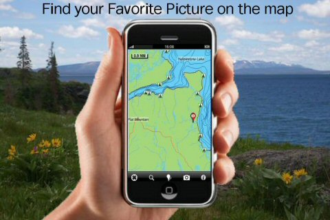
· Insert Unlimited Markers near favorite places on the map
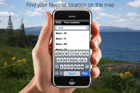
· Search your Favorite points directly
· Zoom, Rotate and Pan fast just by a finger touch
· Navigate and see your GPS position on the map
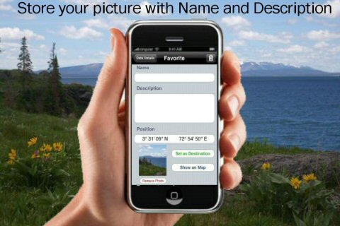
· Geo-Tagged photo management
· Set On/Off Elevation Contours if you feel data is cluttering
What's New in This Release:
· Fixed bug on Favorites and Camera management
What's New in 3.1:
· GPS Info Page
· Faster Names Search
Like it? Share with your friends!
If you got an error while installing Themes, Software or Games, please, read FAQ.
Supported operating systems:
Apple iOS 10.x (iPad), Apple iOS 10.x (iPhone), Apple iOS 11.x (iPad), Apple iOS 12.x (iPad), Apple iOS 12.x (iPhone), Apple iOS 4.0.x (iPhone), Apple iOS 4.0.x (iPod Touch), Apple iOS 4.2.x (iPad), Apple iOS 4.2.x (iPhone), Apple iOS 4.2.x (iPod Touch), Apple iOS 4.3.x (iPad), Apple iOS 4.3.x (iPhone), Apple iOS 4.3.x (iPod Touch), Apple iOS 5.0 (iPad), Apple iOS 5.0 (iPhone), Apple iOS 5.0 (iPod Touch), Apple iOS 6.0 (iPad), Apple iOS 6.0 (iPhone), Apple iOS 6.0 (iPod Touch), Apple iOS 7.0 (iPad), Apple iOS 7.0 (iPhone), Apple iOS 7.0 (iPod Touch), Apple iOS 8.x (iPad), Apple iOS 8.x (iPhone), Apple iOS 8.x (iPod Touch), Apple iOS 9.x (iPad), Apple iOS 9.x (iPhone), Apple iOS 9.x (iPod Touch)
Similar Software:
Grenadines & Grenada - GPS Map Navigator Grenadines & Grenada - GPS Map Navigator - FlytoMap provides complete, quick and easy to use map applications for navigation. Continues in the tradition of offering depth of information and functionality across expected places all over the world, exploring the map you get maximum details obtaining detailed information of every object on the map
Guadalupe Mountains National Park - GPS Map Navigator Guadalupe Mountains National Park - continues in the tradition of offering depth of information and functionality across expected places all over the world, exploring the map you get maximum details obtaining detailed information of each object on the map
Warsaw GPS Guide The only thing we do, help you to move freely as an alien, by "Offline" & "GPS"
Japan GPS Japan GPS is a professional Car, Bike and Pedestrian navigation system for iPhone and iPad. This system not only for Car navigation, but also for pedestrian.
· 2D and 3D navigation mode and map.
· The speed is very fast.
· Using vector map which owns small size and can zoom in any level.
· Elegant operations
Find a Coffee Find a Coffee - Picture the scene: It's cold. You're broke. Your partner has left you. You just got fired. You're lost and don't know where the closest coffee shop is.
Never fear: Find-a-coffee is happy to save you
CoPilot Live Premium Europe (iPhone) CoPilot Live Premium Europe is the essential voice-guided sat navigation app to get you where you need to go, by the way that suits you best.
Detailed street maps of Western and Eastern Europe are stored on-board your iPhone so you don’t need to rely on your mobile connection for navigation or worry about losing directions in coverage dead spots
Sygic Polska: GPS Navigation Sygic Polska: GPS Navigation - Sygic is a premium turn-by-turn GPS navigation application
NAVIGON MobileNavigator EU 10 NAVIGON MobileNavigator EU 10 - With the NAVIGON MobileNavigator you can transform your iPhone into a fully functional mobile navigation system that is every bit as good as the multi-award-winning personal navigation devices from NAVIGON in terms of its user-friendliness and features
Sygic Western Europe: GPS Navigation Sygic Western Europe: GPS Navigation - Sygic is a premium turn-by-turn GPS navigation application. Sygic boasts an intuitive interface: drag the map, pinch to zoom, change point of view using built-in compass and tap target square to choose action. Sygic is comfortable and safe: with advanced routing optimized for Real-Time Traffic
Lakes: Texas Lakes: Texas - Continues in the tradition of offering depth of information and functionality across expected places all over the world, exploring the map you get maximum details obtaining detailed information of each object on the map
Marine: Hebrides - GPS Map Navigator Marine: Hebrides - GPS Map Navigator - FlytoMap provides complete, quick and easy to use map applications for navigation for iPhone. Continues in the tradition of offering depth of information and functionality across expected places all over the world, exploring the map you get maximum details obtaining detailed information of every object on the map
Marine: UK-Ireland-Netherlands - GPS Map Navigator Marine: UK-Ireland-Netherlands - GPS Map Navigator - The FlyToMap App resembles a Chart plotter on your mobile device, to the Great Waterways of UK-Ireland-Netherlands providing value added map features and information for sailing signifying all the nautical standards for safe navigation
Adirondack State Park - Standard Adirondack State Park - Standard - Continues in the tradition of offering depth of information and functionality across expected places all over the world, exploring the map you get maximum details obtaining detailed information of each object on the map
Marine: Wales and West England - GPS Map Navigator Marine: Wales and West England - GPS Map Navigator - FlytoMap provides complete, quick and easy to use map applications for navigation for iPhone. Continues in the tradition of offering depth of information and functionality across expected places all over the world, exploring the map you get maximum details obtaining detailed information of every object on the map
Sequoia - Kings National Park - GPS Map Navigator Sequoia - Kings National Park - GPS Map Navigator - Continues in the tradition of offering depth of information and functionality across expected places all over the world, exploring the map you get maximum details obtaining detailed information of each object on the map
Marine: Alaska South East HD - GPS Map Navigator Marine: Alaska South East HD - GPS Map Navigator - FlytoMap provides complete, quick and easy to use map applications for navigation for iPad. Continues in the tradition of offering depth of information and functionality across expected places all over the world, exploring the map you get maximum details obtaining detailed information of every object on the map
Marine: Gargano - GPS Map Navigator Marine: Gargano - GPS Map Navigator - Flytomap offers revolutionary Marine applications for iPhone, iPod Touch & iPad!!!
Go boating in the wonderful Gargano waters - discovering the bays of Gargano is an unforgettable experience.
Gorgano Marine Map contains embedded Electronic Nautical charts compressed to a large coverage
Big Cypress National Preserve - GPS Map Navigator Big Cypress National Preserve - GPS Map Navigator - Continues in the tradition of offering depth of information and functionality across expected places all over the world, exploring the map you get maximum details obtaining detailed information of each object on the map
Catoctin Mountain Park - GPS Map Navigator Catoctin Mountain Park - GPS Map Navigator - Continues in the tradition of offering depth of information and functionality across expected places all over the world, exploring the map you get maximum details obtaining detailed information of each object on the map
Comments on Abruzzo, Lazio e Molise National Park - GPS Map Navigator:
Comments not found
If you noted an error or download link is broken, please, report it via this page or use comments.
Abruzzo, Lazio e Molise National Park - GPS Map Navigator is compatible with your device Apple iPad Pro 12.9-inch 2020 4th gen A2233 TD-LTE CN 1TB (Apple iPad 8,12)

")


")


