Tyne & Wear Metro for iPad by Zuti - The new Tyne & Wear Metro map makes it easy to travel in and around the city using the Nexus Metro system. Unlike old fashioned schematic style maps this product contains a geographically accurate central area showing major streets, parks and places of interest etc, allowing the user to easily get their bearings.
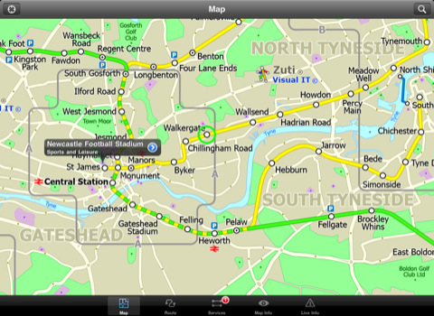
MAP
The map is hand drawn by Visual IT and provides a unique geographically based view of Tyne & Wear with many places of interest drawn directly on the background so you can easily get your bearings when traveling around the area. You can also use your inbuilt GPS to accurately locate and track yourself within the city centre and see the nearest transportation stop and distance to it. This is the only public transportation route planner with this ability.
Tap on the map for location information, use the inbuilt search feature or choose from a list of locations. Places of interest, museums, hotels, parks, restaurant, shops, hospitals, streets, etc, are also included. The route planner will automatically suggest the nearest station to any place of interest you select.
MINUTE MAP
Another great feature is the “Minute Map” option which allows you to see the travel times from a start point to all other locations on the map. This is a unique way to view the topology of an area and gauge traveling times.
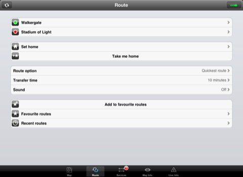
ROUTING
The application does not require an internet connection and will always be available to display a clear and detailed view of the city transport systems, plus list and animate the optimum route for your journey. This product provides the fastest route calculations of any mobile routing application (virtually instantaneous) using actual published journey times with the ability to select the quickest route or the route with the least changes.
LIVE INFO
When an internet connection is available, optional "Live Information" on the current state of the transport services can be viewed, allowing you to plan your journeys in advance and avoid any potential delays. Unique to this application is the ability to turn off services that are out of action and automatically calculate an alternative route.
· Full offline map and routing, no internet connection required.
· Colourful clear custom drawn geographically accurate mapping.
· Animates the route and allows tracking of the journey using GPS
· Instantly see the route of any transport service drawn on the map.
· Save and recall favourite and recent journeys.
· Take me home feature.
· Unique "Minute Map" feature allows quick view of all journey times from a start location.
· Services can be turned on or off, routing round problems.
· GPS location and tracking.
· Streets, Places of interest etc built into the application.
· Access to live service information.
What's New in This Release:
· Completely new map and routing.
· Many enhancements and added features.
Like it? Share with your friends!
If you got an error while installing Themes, Software or Games, please, read FAQ.
Supported operating systems:
Apple iOS 10.x (iPad), Apple iOS 11.x (iPad), Apple iOS 12.x (iPad), Apple iOS 4.2.x (iPad), Apple iOS 4.3.x (iPad), Apple iOS 5.0 (iPad), Apple iOS 6.0 (iPad), Apple iOS 7.0 (iPad), Apple iOS 8.x (iPad), Apple iOS 9.x (iPad), Apple iPhone OS 3.2.x (iPad)
Similar Software:
iBART Live iBART Live From the makers of the acclaimed iBART, iBART Live is an intelligent transit application for Bay Area Rapid Transit. It is essential to all BART riders — from the occasional to the daily, the tourist to the commuter
Priceline Priceline - Power up priceline.com's Hotel Negotiator app and let the Priceline Negotiator, William Shatner, find you last-minute Name Your Own Price hotel rooms that you can book at savings of up to 50%.
· Choose a city and see multiple winning hotel bids for the hotel star levels and parts of the city you want
Minneapolis Maps Minneapolis Maps -software that helps you download and store the travel maps and plans you need. This super-handy app lets you download publicly available maps and store them on your iPhone or iPod Touch. You can download the maps when you have fast wifi connection - and then use any time in the future without delay
Short Trips Around Houston Short Trips Around Houston - GPSmyCity.com's day trips and weekend getaways appliaction is a powerful tool for planning a weekend away from the city. With a well researched list of getaway spots around the city you live in, you can explore natural wonders, regional history, and small town charm within a short drive from your home
TransitM&S Phoenix TransitM&S Phoenix - TransitM&S is an easy-to-use transit application that provides bus info for Valley Metro Transit at greater Phoenix metro area.
The app is designed for offline use. It is ideal for iPod Touch users. Even for iPhone users, it is designed to save money because AT&T no longer offers the unlimited data plan
Bremerhaven World Travel Bremerhaven World Travel - map with locate me function makes you free to move.
Background reading always accompanies you on your trip
London Bus for iPad by Zuti London Bus for iPad by Zuti - The new Zuti London Bus map has finally arrived, making it easy to travel by bus anywhere in central London. This clear and colourful map covers a detailed street level area of 6 miles by 4 miles and includes over 1300 bus stops and 189 bus routes
Virginia Wine In My Pocket Virginia Wine In My Pocket - According to the Travel Channel, "Virginia is carving its own niche in the little black books of savvy wine lovers searching for the next big thing."
Virginia Wine in My Pocket is a guide for travelers in Virginia wine country
Priceline.com: Hotels, Flights & Rental Cars Priceline.com: Hotels, Flights & Rental Cars - Power up priceline.com's Hotel Negotiator app and let the Priceline Negotiator, William Shatner, find you last-minute Name Your Own Price hotel rooms that you can book at savings of up to 50%.
· Choose a city and see multiple winning hotel bids for the hotel star levels and parts of the city you want
Weekend Trips Near San Antonio Weekend Trips Near San Antonio - GPSmyCity.com's day trips application is a powerful tool for planning your weekend getaways. With a well researched list of weekend getaway spots around the city you live in and the powerful navigation features built-in, you will never be bored on a weekend.
This app works on iPhone, iPad and iPod Touch
Other Software by developer «Visual IT»:
Tube Hong Kong (Series 60) Tube Hong Kong (Series 60) - Our highly acclaimed Tube application that guides you around the subway system of Hong Kong is now available for your Series 60 Symbian powered phone. An essential addition to your phone for locals and tourists alike.
· A detailed clear colour map of the transport system fully scrollable.
· Quick find station utility
Tube 2 Budapest (UIQ) Tube 2 Budapest (UIQ) - This map package for Tube 2 consists of a fully scrollable detailed map of the Budapest metro system and HEV suburban railway.
Plan journeys on this system, list details of the quickest routes and see a superb animated display of your journey tracking around the system map
Tube 2 Paris Touristic (Palm OS) Tube 2 Paris Touristic (Palm OS) - This map package for Tube 2 is the ideal map for the tourist or business traveller who needs to get around Paris using the metro system and would like to know just exactly where they are. The map geographically locates all the central stations, making it much more informative than the official topological map
Tube Moscow (UIQ) Tube Moscow (UIQ) - Our award winning and highly acclaimed application that guides you around the complex metro system of Moscow is now available for your Symbian UIQ phone.
An essential addition to your P800 / P900 / P910 if you travel in or around this city
· A detailed clear colour map of the Moscow metro system fully scrollable
London Master A-Z for iPad London Master A-Z for iPad - This clear and colourful high quality map covers the same area as the market leading A-Z "Master Atlas of Greater London Street Atlas". The familiar look makes this by far the easiest London iPad map to use. The map is drawn by real cartographers with the detailed care and the human touch of emphasis and colour that A-Z are famous for
Tube 2 Madrid (Palm OS) Tube 2 Madrid (Palm OS) - This map package for Tube 2 consists of a fully scrollable detailed map of the Madrid metro system.
Plan journeys on this system, list details of the quickest routes and see a superb animated display of your journey tracking around the system map
London Tube for iPad by Zuti London Tube for iPad by Zuti - "London Tube 10" is a superb geographically based map and route planner for the London Underground, Overground, Docklands Light Railway (DLR), Croydon Tramlink and London Airport Express services
Tube 2 Barcelona Pro (UIQ3) Tube 2 Barcelona Pro (UIQ3) - This map package for Tube 2 consists of a fully scrollable detailed map of the Barcelona metro & rail system and linked street maps of central Barcelona.
Plan journeys on the metro system, list details of the quickest routes and see a superb animated display of your journey tracking around the system map
Manchester Mini A-Z Manchester Mini A-Z - "Manchester Mini A-Z" is a digital rendition of the famous Geographers Company Mini A-Z Atlas for Manchester
Tube 2 Tokyo (UIQ) Tube 2 Tokyo (UIQ) - This map package for Tube 2 consists of a fully scrollable detailed map of the Tokyo city subway & JR rail system

")


")
")
")
")

")

")

")