Platforms: iPhone, iPad, iPod Touch, Apple iPhone OS
Categories: Travel & Navigation
Upload date: 29 Oct 11
Developer: Visual IT
License: Commercial
Price: 9.99 $
Downloads: 16
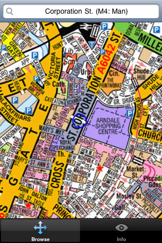
Manchester Mini A-Z - "Manchester Mini A-Z" is a digital rendition of the famous Geographers Company Mini A-Z Atlas for Manchester. This mini street atlas includes coverage of Kearsley, Whitefield, Middleton, Chadderton, Oldham, Walkden, Swinton, Prestwich, Failsworth, Worsley, Salford, Droylsden, Ashton-Under-Lyne, Eccles, Trafford Park, Salford, Dukinfield, Urmston, Stretford, Levenshulme, Reddish, Denton, Sale, Brinnington, Stockport, Wythenshawe, Cheadle and Manchester Airport.
The index section of the atlas lists: streets, walkways, places of interest, selected flats, place and area names plus National Rail and Metrolink stations. Also included is a listing of hospitals, hospices, and NHS Walk-in Centres that are covered by this atlas
This map is drawn by real cartographers with the detailed care and human touch of emphasis and colour that A-Z are famous for. Internet maps are OK but you really can’t beat the genuine article.
With the maps installed on your device there is never any need for an internet connection enabling you to access the map anywhere and at anytime. This application starts up in under 5 seconds and can find any location on the map in under 2 seconds. You can also use your inbuilt location services (GPS, Wifi, etc) to locate your position on the map.
Visual IT have partnered with the “Geographers A-Z Map Company” and negotiated a license to produce this map for iPhone or iPod Touch users at this very competitive price.
What's New in This Release:
· Support for retina display
· New "Measure Tool"
· Bug fix for the next iOS release
Like it? Share with your friends!
If you got an error while installing Themes, Software or Games, please, read FAQ.
Supported operating systems:
Apple iOS 10.x (iPad), Apple iOS 10.x (iPhone), Apple iOS 11.x (iPad), Apple iOS 12.x (iPad), Apple iOS 12.x (iPhone), Apple iOS 4.0.x (iPhone), Apple iOS 4.0.x (iPod Touch), Apple iOS 4.2.x (iPad), Apple iOS 4.2.x (iPhone), Apple iOS 4.2.x (iPod Touch), Apple iOS 4.3.x (iPad), Apple iOS 4.3.x (iPhone), Apple iOS 4.3.x (iPod Touch), Apple iOS 5.0 (iPad), Apple iOS 5.0 (iPhone), Apple iOS 5.0 (iPod Touch), Apple iOS 6.0 (iPad), Apple iOS 6.0 (iPhone), Apple iOS 6.0 (iPod Touch), Apple iOS 7.0 (iPad), Apple iOS 7.0 (iPhone), Apple iOS 7.0 (iPod Touch), Apple iOS 8.x (iPad), Apple iOS 8.x (iPhone), Apple iOS 8.x (iPod Touch), Apple iOS 9.x (iPad), Apple iOS 9.x (iPhone), Apple iOS 9.x (iPod Touch), Apple iPhone OS 3.1.x, Apple iPhone OS 3.1.x (iPod Touch), Apple iPhone OS 3.2.x (iPad)
Similar Software:
Moscow City Travel Guide Travel Moscow City Travel Guide Travel - It is a very practical city guide since it is designed to be used by itineraries. There are 4 different itineraries for the city depending on the duration of your journey. We also provide tips and advices to travelers, how to get into the city, how to move around, where to shop, where to go at night, most popular places, safety tips, etc..
Congaree Swamp National Monument - GPS Map Navigator Congaree Swamp National Monument - GPS Map Navigator - Continues in the tradition of offering depth of information and functionality across expected places all over the world, exploring the map you get maximum details obtaining detailed information of each object on the map
Marine: Cherbourg to Channel Islands - Solent Marine: Cherbourg to Channel Islands - Solent - Cherbourg to Channel Islands is a high quality map with detailed water navigation information and important features compressed to assure the bigger coverage.
Map contains embedded electronic nautical charts from IHO's compressed to a large coverage
Rochester (NY) Map Offline Rochester (NY) Map Offline - This will be perfect when you are traveling and you don't have internet connection. This Offline Maps is not a replacement of Google Maps. It is used when you don't have internet connection and want to use maps
Miami Map Offline Miami Map Offline - This will be perfect when you are traveling and you don't have internet connection. This Offline Maps is not a replacement of Google Maps. It is used when you don't have internet connection and want to use maps
Orlando Maps Offline Orlando Maps Offline - This will be perfect when you are traveling and you don't have internet connection. This Offline Maps is not a replacement of Google Maps. It is used when you don't have internet connection and want to use maps
Yosemite National Park - Topo Yosemite National Park - Topo - Continues in the tradition of offering depth of information and functionality across expected places all over the world, exploring the map you get maximum details obtaining detailed information of each object on the map
San Jose Walking Tours and Map San Jose Walking Tours and Map - No need to hop on a tour bus or join a group; now you can explore all the best attractions on your own, at your own pace, and at a cost that is only a fraction of what you would normally pay for a guided tour
Other Software by developer «Visual IT»:
Tube 2 Engine (UIQ3) Tube 2 Engine (UIQ3) - Transform your PDA into a fully scrollable detailed map of one of the worlds subway or metro systems.
See your journeys come alive with a superb animated display.
Save hours by automatically having the quickest routes to hand, with all the details you need including line changes, platform directions and accurate journey times
Rough Guide Map Amsterdam for UIQ Rough Guide Map Amsterdam for UIQ - Discover and explore Amsterdam using full colour interactive linked maps, in this simple to use PDA version of The Rough Guide Amsterdam Map.
Find all the top tourist spots and key attractions with ease, information on the city and its sights can be quickly displayed with links to photographs and map locations
Tube 2 Melbourne (UIQ3) Tube 2 Melbourne (UIQ3) - This map package for Tube 2 consists of a fully scrollable detailed map of the Melbourne metro & rail system.
Plan journeys on this system, list details of the quickest routes and see a superb animated display of your journey tracking around the system map
Tube 2 Portland (Palm OS) Tube 2 Portland (Palm OS) - This map package for Tube 2 consists of a fully scrollable detailed map of the Portland rail system.
Plan journeys on this system, list details of the quickest routes and see a superb animated display of your journey tracking around the system map
Rough Guides Map San Francisco Rough Guides Map San Francisco... These guides are a series of fantastic interactive maps.
Produced in conjunction with the premier travel publisher Rough Guides.
Discover and explore San Francisco using full colour interactive linked maps, in this simple to use PDA version of The Rough Guides San Francisco
London Mini A-Z London Mini A-Z - This map is a digital rendition of the famous "London A-Z Mini Atlas" and covers an area from West Hendon in the North West to Grove Park in the South East. Add this application to your iPhone or iPod Touch and you will have instant access to all 352 pages of the London Mini A-Z printed map
Tube 2 Dublin Pro (Palm OS) Tube 2 Dublin Pro (Palm OS) - This map package for Tube 2 consists of a fully scrollable detailed map of the Dublin rail system and linked street maps of central Dublin.
Plan journeys on the rail system, list details of the quickest routes and see a superb animated display of your journey tracking around the system map
Tube 2 New York City (Palm OS) Tube 2 New York City (Palm OS) - This map package for Tube 2 consists of a fully scrollable detailed map of the New York City MTA subway system.
Plan journeys on this system, list details of the quickest routes and see a superb animated display of your journey tracking around the system map
Paris Metro by Zuti Paris Metro by Zuti - This Zuti application contains a visually unique map of the Paris transport system and a superb animated journey planner to help you get around the Metro, RER, SNCF, Tram, Tvm, and Vogueo services. Now revised and updated to include a larger geographic area which covers more of the outlying areas surrounding Paris
London Visitors A-Z for iPad London Visitors A-Z for iPad - The London Visitors A-Z map of central London is designed especially for the tourist

")


 Map Offline")


")

")
")


")
")

