Buy Apple iPad Pro 12.9-inch 2020 4th gen A2229 WiFi 1TB (Apple iPad 8,11) Cinque Terre National Park - GPS Map Navigator Application in Travel & Navigation Tag
Platforms: iPhone, iPad, iPod Touch, Apple iPhone OS
Categories: Travel & Navigation
Upload date: 10 Sep 11
Developer: Flytomap
License: Commercial
Price: 2.99 $
Downloads: 35
Cinque Terre National Park - GPS Map Navigator - FlytoMap provides complete, quick and easy to use map applications for navigation for iPhone. Continues in the tradition of offering depth of information and functionality across expected places all over the world, exploring the map you get maximum details obtaining detailed information of every object on the map.
FlytoMap processes different types of maps for navigation for different categories:
WATER MAPS (Marine):
Water map navigator is the new ‘Marine Navigator for iPhone’ contains embedded Electronic Nautical Charts (ENC) from NOAA compressed to a large coverage. You can now download the application and transform your iPhone in a chart plotter with best NOAA, ENC S57 cartography; which includes Anchoring areas, Fishing areas, restriction areas, obstructions, rocks, Buoys, Beacons, Lights, Depth contours with Values display on map, Spot Soundings and more. The only marine app available in the market with such huge information. Every effort is made to be as accurate as possible when presenting information for every destination.
PARK MAPS:
Park map applications are extremely advanced contains embedded electronic charts with all information collected from the National Park Service and local sources. The maps contain all multiple trails (Hiking, biking, Stairway trails, Bicycle trails, Equestrian trails etc.,) and Point of interests (POI) like Campgrounds, Eating places, Ranger Stations, Picnic areas, Boat/Canoe launching, Parking areas etc., which are provided depending on the relevant park areas they exist.
LAKE MAPS:
We offer high quality lake maps with detailed information and important features compressed to assure the larger coverage in USA region. Lake maps contain most important DNR lakes with detailed ‘Depth Contours, Boat Ramps, Fishing spots etc. Also includes Trails, Roads and Railways information.
TRAVEL MAPS:
These Maps treat you mostly with information of both Marine and terrain correspondingly. These are the most preferable Maps to travel especially for fascinating recreational voyages, map focus the best Beach spots along the Coast line, Major ports, Sailing, Fishing, Picnic areas, Parks, Hiking, Biking, Clubs, restaurants, Famous Hotels, Museums, Shopping areas, and much more.
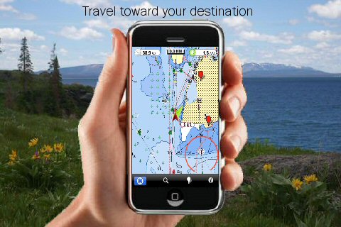
· Use Latitudes and Longitudes to go to your favorite places
· Insert the target/destination 'Waypoint' and see in real time your speed, distance and direction to destination
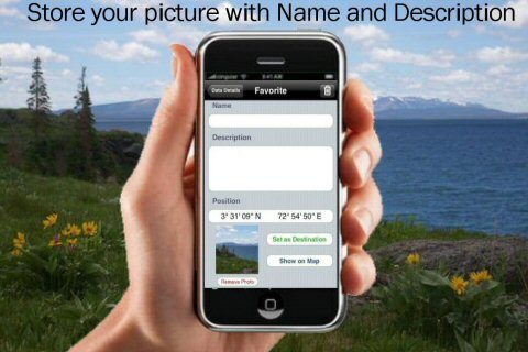
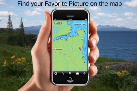
· Insert Unlimited Markers near favorite places on the map
· Search your Favorite points directly
· Zoom, Rotate and Pan fast just by a finger touch
· Navigate and see your GPS position on the map
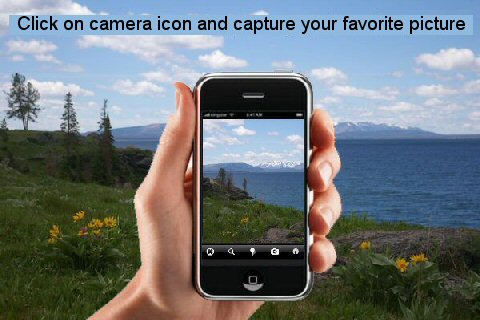
· Geo-Tagged photo management
· Set On/Off Elevation Contours if you feel data is cluttering
What's New in This Release:
· Added GPS info page
Like it? Share with your friends!
If you got an error while installing Themes, Software or Games, please, read FAQ.
Supported operating systems:
Apple iOS 10.x (iPad), Apple iOS 10.x (iPhone), Apple iOS 11.x (iPad), Apple iOS 12.x (iPad), Apple iOS 12.x (iPhone), Apple iOS 4.0.x (iPhone), Apple iOS 4.0.x (iPod Touch), Apple iOS 4.2.x (iPad), Apple iOS 4.2.x (iPhone), Apple iOS 4.2.x (iPod Touch), Apple iOS 4.3.x (iPad), Apple iOS 4.3.x (iPhone), Apple iOS 4.3.x (iPod Touch), Apple iOS 5.0 (iPad), Apple iOS 5.0 (iPhone), Apple iOS 5.0 (iPod Touch), Apple iOS 6.0 (iPad), Apple iOS 6.0 (iPhone), Apple iOS 6.0 (iPod Touch), Apple iOS 7.0 (iPad), Apple iOS 7.0 (iPhone), Apple iOS 7.0 (iPod Touch), Apple iOS 8.x (iPad), Apple iOS 8.x (iPhone), Apple iOS 8.x (iPod Touch), Apple iOS 9.x (iPad), Apple iOS 9.x (iPhone), Apple iOS 9.x (iPod Touch)
Similar Software:
Newport News (VA,USA) Map Offline Newport News (VA,USA) Map Offline - This will be perfect when you are traveling and you don't have internet connection. This Offline Maps is not a replacement of Google Maps. It is used when you don't have internet connection and want to use maps
CoPilot Live Standard North America CoPilot Live Standard North America - Build your own personal navigation app. CoPilot Live Standard gives you turn-by-turn voice-guided GPS navigation throughout the U.S. and Canada with 2D maps and automatic route calculation
NAVIGON MobileNavigator Eastern Europe NAVIGON MobileNavigator Eastern Europe - With the NAVIGON MobileNavigator you can transform your iPhone into a fully functional mobile navigation system that is every bit as good as the multi-award-winning personal navigation devices from NAVIGON in terms of its user-friendliness and features
CoPilot Live HD North America CoPilot Live HD North America - CoPilot Live HD makes complete use of the iPad's large touch screen in portrait or landscape, displaying the route ahead clearly and with beautiful hi-resolution graphics
Heidelberg Maps Offline Heidelberg Maps Offline - This will be perfect when you are traveling and you don't have internet connection. This Offline Maps is not a replacement of Google Maps. It is used when you don't have internet connection and want to use maps
Sygic Brasil: GPS Navigation Sygic Brasil: GPS Navigation - Sygic is a premium turn-by-turn GPS navigation application. Sygic boasts an intuitive interface: drag the map, pinch to zoom, change point of view using built-in compass and tap target square to choose action
CoPilot Live Premium Europe (iPhone) CoPilot Live Premium Europe is the essential voice-guided sat navigation app to get you where you need to go, by the way that suits you best.
Detailed street maps of Western and Eastern Europe are stored on-board your iPhone so you don’t need to rely on your mobile connection for navigation or worry about losing directions in coverage dead spots
Mobile Maps Morocco GPS Navigation Mobile Maps Morocco GPS Navigation - Sygic Mobile Maps is the most complete turn-by-turn, voice guided navigation software.
The application does not require Internet connection to operate
CoPilot Live Premium Brasil CoPilot Live Premium Brasil is the full-featured voice-guided GPS navigation application that guides you where you need to go, in-car or on foot.
Detailed street maps of Brasil are stored on-board your iPhone so you don’t need to rely on your mobile connection for navigation.
CoPilot Live Premium puts you in control, with a choice of routes to your destination
Other Software by developer «Flytomap»:
Marine: Chesapeake Bay - GPS Map Navigator Marine: Chesapeake Bay - GPS Map Navigator - Continues in the tradition of offering depth of information and functionality across expected places all over the world, exploring the map you get maximum details obtaining detailed information of each object on the map
Marine: Melbourne HD - GPS Map Navigator Marine: Melbourne HD - GPS Map Navigator - FlytoMap provides complete, quick and easy to use map applications for navigation for iPad. Continues in the tradition of offering depth of information and functionality across expected places all over the world, exploring the map you get maximum details obtaining detailed information of every object on the map
Virgin Islands - GPS Map Navigator Virgin Islands - GPS Map Navigator - FlytoMap provides complete, quick and easy to use map applications for navigation for iPhone. Continues in the tradition of offering depth of information and functionality across expected places all over the world, exploring the map you get maximum details obtaining detailed information of every object on the map
FlyToMap GPS HD - All in One FlyToMap GPS HD - All in One - FlytoMap provides complete, quick and easy to use map applications for navigation for iPad. Continues in the tradition of offering depth of information and functionality across expected places all over the world, exploring the map you get maximum details obtaining detailed information of every object on the map
US Great Lakes HD - GPS Map Navigator US Great Lakes HD - GPS Map Navigator - FlytoMap provides complete, quick and easy to use map applications for navigation for iPad. Continues in the tradition of offering depth of information and functionality across expected places all over the world, exploring the map you get maximum details obtaining detailed information of every object on the map
Marine : Cote d'Azur - GPS Map Navigator Marine : Cote d'Azur - GPS Map Navigator - FlytoMap provides complete, quick and easy to use map applications for navigation for iPhone. Continues in the tradition of offering depth of information and functionality across expected places all over the world, exploring the map you get maximum details obtaining detailed information of every object on the map
Cuyahoga Valley National Park - Standard Cuyahoga Valley National Park - Standard - Continues in the tradition of offering depth of information and functionality across expected places all over the world, exploring the map you get maximum details obtaining detailed information of each object on the map
Miami to Key West HD - Water Map Navigator Miami to Key West HD - FlytoMap provides complete, quick and easy to use map applications for navigation for iPad. Continues in the tradition of offering depth of information and functionality across expected places all over the world, exploring the map you get maximum details obtaining detailed information of every object on the map
Parco dei Cetacei - (Marine: Mar Ligure) - GPS Map Navigator Parco dei Cetacei - (Marine: Mar Ligure) - GPS Map Navigator - Liguria region is well-known by international travelers from more than a century and have recognized the warmth and beauty of the magnificent Italian Riviera. Best place to enjoy warm water, wide sandy beaches, and posh resorts, discriminating travelers to come and explore
Lakes: Massachusetts Lakes: Massachusetts - FlytoMap provides complete, quick and easy to use map applications for navigation for iPhone. Continues in the tradition of offering depth of information and functionality across expected places all over the world, exploring the map you get maximum details obtaining detailed information of every object on the map

")


 Map Offline")


")


 - GPS Map Navigator")
