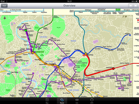
Rome Metro 10 -The Zuti Rome Metro application is a superb geographically based map and route planner for the Metro, Tram, Urban and Regional rail systems. Unlike old fashioned schematic style maps this product contains a geographically accurate central area showing major streets, parks and places of interest etc, allowing the user to easily get their bearings.
MAP
The map is hand drawn by Visual IT and provides a unique geographically based view of Rome with many places of interest drawn directly on the background so you can easily get your bearings when traveling around the city. You can also use your inbuilt GPS to accurately locate and track yourself within the city centre and see the nearest transportation stop and distance to it. This is the only pubic transportation route planner with this ability. Tap on the map for location information, use the inbuilt search feature or choose from a list of locations. Places of interest, museums, hotels, parks, restaurant, shops, hospitals, streets, etc, are also included. The route planner will automatically suggest the nearest station to any place of interest you select.
MINUTE MAP
Another great feature is the “Minute Map” option which allows you to see the travel times from a start point to all other locations on the map. This is a unique way to view the topology of a city and gauge traveling times.
ROUTING
The application does not require an internet connection and will always be available to display a clear and detailed view of the city transport systems, plus list and animate the optimum route for your journey. This product provides the fastest route calculations of any mobile routing application (virtually instantaneous) using actual published journey times with the ability to select the quickest route or the route with the least changes.
What's New in This Release:
· Improved user interface.
· Save and recall favourite routes.
· Instant Minute Map from any tap location.
· Show any transport service drawn on the map.
· Minor map updates.
Like it? Share with your friends!
If you got an error while installing Themes, Software or Games, please, read FAQ.
Supported operating systems:
Apple iOS 10.x (iPad), Apple iOS 11.x (iPad), Apple iOS 12.x (iPad), Apple iOS 4.2.x (iPad), Apple iOS 4.3.x (iPad), Apple iOS 5.0 (iPad), Apple iOS 6.0 (iPad), Apple iOS 7.0 (iPad), Apple iOS 8.x (iPad), Apple iOS 9.x (iPad), Apple iPhone OS 3.2.x (iPad)
Similar Software:
Washington Metro for iPad by Zuti The new Washington Metro 10 map makes it easy to travel in and around the city using the WMATA Metro, MARC and VME systems. Also included are the Potomac river taxi routes and the DC Circulator bus routes
Cold War Walking Tour in Berlin Cold War Walking Tour in Berlin - No place on Earth stood at the heart of the 20th Century conflict between the ideological poles of Communism and Capitalism like Berlin. A divided city in a divided Germany in a divided Europe in a divided world
trivago for iPad trivago for iPad - Trivago is a hotel price comparison app for iPad. It indexes more than 100 booking sites like Booking.com, Expedia and eBookers, to show you the cheapest accommodations in over 500,000 hotels all over the world.
Finding a hotel is as easy as entering the destination and travel date
Airbnb for iPhone Airbnb for iPhone - The Airbnb app allows you to discover and book unique accommodations all over the world right from your iPhone.
Airbnb is a trusted community which connects you with people who have space for rent. It includes more than 200,000 listings in over 30,000 cities and 192 countries
Best Photography Spots in Cambridge (Lite Version) Best Photography Spots in Cambridge - Cambridge has an evocative array of quintessentially English sights. Use this tour to visit all the must-sees' as well as some off-the-beaten-track spots. As you go collect stunning photographs that capture the essence of this beautiful city
Barcelona Metro 10 for iPad Barcelona Metro 10 - This Zuti application contains a visually unique map of the Barcelona transport system and a superb animated journey planner to help you get around the TMB (Transports Metropolitan de Barcelona), FGC (Ferrocarrils de la Generalitat de Catalunya) Metro and Tram services
Tyne & Wear Metro by Zuti for iPad Tyne & Wear Metro by Zuti for iPad - The new Tyne & Wear Metro map makes it easy to travel in and around the city using the Nexus Metro system. Unlike old fashioned schematic style maps this product contains a geographically accurate central area showing major streets, parks and places of interest etc, allowing the user to easily get their bearings
Orlando Maps Orlando Maps - software that helps you download and store the travel maps and plans you need. This super-handy app lets you download publicly available maps and store them on your iPhone or iPod Touch. You can download the maps when you have fast wifi connection - and then use any time in the future without delay
Tuscany for Foodies Tuscany for Foodies - Tuscany for Foodies introduces you to the best of foodie Tuscany, from the butchers, bakers, and cheese makers who adhere to ancient traditions and proudly sell their goods in small shops, to restaurants large and small that process local ingredients into good-to-eat meals
London Underground for iPad by Zuti London Underground 10 is a superb map and route planner for the London Underground, Overground and Docklands Light Railway (DLR) services. So you can make a quick exit when you leave the train we have now added exit information for all stations on the London Underground
Other Software by developer «Visual IT»:
GB Major Road Atlas (UIQ3) GB Major Road Atlas (UIQ3) - This map package is an essential addition to your Tube 2 maps if you drive in and around Great Britain.
This reference map gives you a clear view of all the major roads in the whole of Great Britain, you can use the quick find feature to locate any of the 30,000 + GB towns and villages in the database
Tube 2 Barcelona Pro (Palm OS) Tube 2 Barcelona Pro (Palm OS) - This map package for Tube 2 consists of a fully scrollable detailed map of the Barcelona metro & rail system and linked street maps of central Barcelona.
Plan journeys on the metro system, list details of the quickest routes and see a superb animated display of your journey tracking around the system map
Tube 2 Berlin (UIQ3) Tube 2 Berlin (UIQ3) - This map package for Tube 2 consists of a fully scrollable detailed map of the Berlin Metro (U-Bahn/S-Bahn).
Plan journeys on this system, list details of the quickest routes and see a superb animated display of your journey tracking around the system map.
Berlin is the capital and largest city in Germany
TUBE 2 Engine Palm Transform your PDA into a fully scrollable detailed map of one of the worlds subway or metro systems
Tube 2 Dublin (Palm OS) Tube 2 Dublin (Palm OS) - This map package for Tube 2 consists of a fully scrollable detailed map of the Dublin rail system.
Plan journeys on this system, list details of the quickest routes and see a superb animated display of your journey tracking around the system map
Tube Hong Kong (Series 60) Tube Hong Kong (Series 60) - Our highly acclaimed Tube application that guides you around the subway system of Hong Kong is now available for your Series 60 Symbian powered phone. An essential addition to your phone for locals and tourists alike.
· A detailed clear colour map of the transport system fully scrollable.
· Quick find station utility
Madrid Metro by Zuti Madrid Metro by Zuti - The new Madrid Metro 10 map makes it easy to travel in and around the city using the the Metro, Renfe Rail and Metro Ligero Rail services. Unlike old fashioned schematic style maps this product contains a geographically accurate central area showing major streets, parks and places of interest etc, allowing the user to easily get their bearings
Berlin Metro 09 Berlin Metro 09 - The "Berlin Metro 09" application is a superb interactive map and route planner for the Berlin Metro (U-Bahn) and Suburban rail (S Bahn) systems. You can also use your inbuilt GPS (will also work with iPod Touch devices) to accurately locate and see the nearest transportation stop and distance to it
London Master A-Z London Master A-Z - This clear and colourful high quality map covers the same area as the market leading A-Z "Master Atlas of Greater London Street Atlas". The familiar look makes this by far the easiest London iPhone map to use. The map is drawn by real cartographers with the detailed care and the human touch of emphasis and colour that A-Z are famous for
Tube 2 Atlanta (UIQ3) Tube 2 Atlanta (UIQ3) - This map package for Tube 2 consists of a fully scrollable detailed map of the Atlanta rail system.
Plan journeys on this system, list details of the quickest routes and see a superb animated display of your journey tracking around the system map

")


")


")
")
")

")
")


")