Buy Apple iPad Pro 12.9-inch 2020 4th gen A2229 WiFi 128GB (Apple iPad 8,11) Pyrenees National Park - GPS Map Navigator Application in Travel & Navigation Tag
Platforms: iPhone, iPad, iPod Touch, Apple iPhone OS
Categories: Travel & Navigation
Upload date: 21 Jul 12
Developer: Flytomap
License: Commercial
Price: 2.99 $
Downloads: 24
Pyrenees National Park - GPS Map Navigator - FlytoMap provides complete, quick and easy to use map applications for navigation for iPhone. Continues in the tradition of offering depth of information and functionality across expected places all over the world, exploring the map you get maximum details obtaining detailed information of every object on the map.
FlytoMap processes different types of maps for navigation for different categories:
WATER MAPS (Marine):
Water map navigator is the new ‘Marine Navigator for iPhone’ contains embedded Electronic Nautical Charts (ENC) from NOAA compressed to a large coverage. You can now download the application and transform your iPhone in a chart plotter with best NOAA, ENC S57 cartography; which includes Anchoring areas, Fishing areas, restriction areas, obstructions, rocks, Buoys, Beacons, Lights, Depth contours with Values display on map, Spot Soundings and more. The only marine app available in the market with such huge information. Every effort is made to be as accurate as possible when presenting information for every destination.
PARK MAPS:
Park map applications are extremely advanced contains embedded electronic charts with all information collected from the National Park Service and local sources. The maps contain all multiple trails (Hiking, biking, Stairway trails, Bicycle trails, Equestrian trails etc.,) and Point of interests (POI) like Campgrounds, Eating places, Ranger Stations, Picnic areas, Boat/Canoe launching, Parking areas etc., which are provided depending on the relevant park areas they exist.
LAKE MAPS:
We offer high quality lake maps with detailed information and important features compressed to assure the larger coverage in USA region. Lake maps contain most important DNR lakes with detailed ‘Depth Contours, Boat Ramps, Fishing spots etc. Also includes Trails, Roads and Railways information.
TRAVEL MAPS:
These Maps treat you mostly with information of both Marine and terrain correspondingly. These are the most preferable Maps to travel especially for fascinating recreational voyages, map focus the best Beach spots along the Coast line, Major ports, Sailing, Fishing, Picnic areas, Parks, Hiking, Biking, Clubs, restaurants, Famous Hotels, Museums, Shopping areas, and much more.
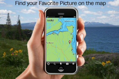
· Use Latitudes and Longitudes to go to your favorite places
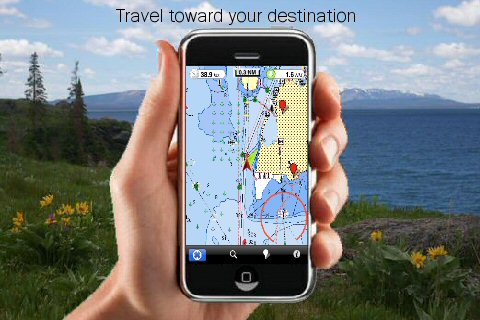
· Insert the target/destination 'Waypoint' and see in real time your speed, distance and direction to destination
· Insert Unlimited Markers near favorite places on the map
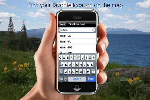
· Search your Favorite points directly
· Zoom, Rotate and Pan fast just by a finger touch
· Navigate and see your GPS position on the map
· Geo-Tagged photo management
· Set On/Off Elevation Contours if you feel data is cluttering
What's New in This Release:
· Display of FlytoMap Overlay
· Improved Track Collection when Walking
· Solved a Configuration Problem when Outdoor layer is active.
What's New in 3.1:
· GPS Info Page
· Faster Names Search
Like it? Share with your friends!
If you got an error while installing Themes, Software or Games, please, read FAQ.
Supported operating systems:
Apple iOS 10.x (iPad), Apple iOS 10.x (iPhone), Apple iOS 11.x (iPad), Apple iOS 12.x (iPad), Apple iOS 12.x (iPhone), Apple iOS 4.0.x (iPhone), Apple iOS 4.0.x (iPod Touch), Apple iOS 4.2.x (iPad), Apple iOS 4.2.x (iPhone), Apple iOS 4.2.x (iPod Touch), Apple iOS 4.3.x (iPad), Apple iOS 4.3.x (iPhone), Apple iOS 4.3.x (iPod Touch), Apple iOS 5.0 (iPad), Apple iOS 5.0 (iPhone), Apple iOS 5.0 (iPod Touch), Apple iOS 6.0 (iPad), Apple iOS 6.0 (iPhone), Apple iOS 6.0 (iPod Touch), Apple iOS 7.0 (iPad), Apple iOS 7.0 (iPhone), Apple iOS 7.0 (iPod Touch), Apple iOS 8.x (iPad), Apple iOS 8.x (iPhone), Apple iOS 8.x (iPod Touch), Apple iOS 9.x (iPad), Apple iOS 9.x (iPhone), Apple iOS 9.x (iPod Touch)
Similar Software:
Barcelona Metro 10 for iPad Barcelona Metro 10 - This Zuti application contains a visually unique map of the Barcelona transport system and a superb animated journey planner to help you get around the TMB (Transports Metropolitan de Barcelona), FGC (Ferrocarrils de la Generalitat de Catalunya) Metro and Tram services
Walking Through Ciudad Vieja in Montevideo Walking Through Ciudad Vieja in Montevideo - Montevideo is not a huge capital city with accompanying hustle and bustle. It’s a mellow (“tranquilo” as often declared by locals) city with a ubiquitously relaxed vibe
Catoctin Mountain Park - GPS Map Navigator Catoctin Mountain Park - GPS Map Navigator - Continues in the tradition of offering depth of information and functionality across expected places all over the world, exploring the map you get maximum details obtaining detailed information of each object on the map
Acapulco Walking Tours and Map Acapulco Walking Tours and Map - No need to hop on a tour bus or join a group; now you can explore all the best attractions on your own, at your own pace, and at a cost that is only a fraction of what you would normally pay for a guided tour
Stuttgart (Germany) Map Offline Stuttgart (Germany) Map Offline - This will be perfect when you are traveling and you don't have internet connection. This Offline Maps is not a replacement of Google Maps. It is used when you don't have internet connection and want to use maps
Turku Map Offline Turku Map Offline - This will be perfect when you are traveling and you don't have internet connection. This Offline Maps is not a replacement of Google Maps. It is used when you don't have internet connection and want to use maps
Tallahassee (FL, USA) Map Offline Tallahassee (FL, USA) Map Offline - This will be perfect when you are traveling and you don't have internet connection. This Offline Maps is not a replacement of Google Maps. It is used when you don't have internet connection and want to use maps
Smart Maps - Honolulu (Oahu) Smart Maps - Honolulu (Oahu) - Smart Maps offers you an offline street level map, allowing you to search or navigate without an internet connection. Smart Maps will save you the money you pay for expensive data roaming charges or additional costs for local internet traffic.
· No internet connection required
Christchurch Walking Tours and Map This application presents you several self-guided walking tours to see the best of the city, and it comes with detailed tour route maps and powerful navigation features to guide you from one sight to the next
Helsinki Offline Street Map Helsinki Offline Street Map - You don't need to have internet connection for this to work as the map is stored on your iPhone or iPod Touch. Ideal for saving roaming charges or having to find the local wifi to access the built-in map application.
What's New in This Release:
· iOS 5 compatibility changes.
· Further bug fixes and improvements
Other Software by developer «Flytomap»:
Lake Eufaula - Fishing Lake Eufaula - Fishing - Lake Eufaula is the largest lake located in the state of Oklahoma. Offers a variety of recreational opportunities for everyone and is a fabulous tourist attraction. The shoreline ranges from vast area of sandy beaches to rocky bluffs
Marine: Chesapeake Bay - GPS Map Navigator Marine: Chesapeake Bay - GPS Map Navigator - Continues in the tradition of offering depth of information and functionality across expected places all over the world, exploring the map you get maximum details obtaining detailed information of each object on the map
Antigua - GPS Map Navigator Antigua - GPS Map Navigator - FlytoMap provides complete, quick and easy to use map applications for navigation for iPhone. Continues in the tradition of offering depth of information and functionality across expected places all over the world, exploring the map you get maximum details obtaining detailed information of every object on the map
Big Bend National Park - GPS Map Navigator Big Bend National Park - GPS Map Navigator - Continues in the tradition of offering depth of information and functionality across expected places all over the world, exploring the map you get maximum details obtaining detailed information of each object on the map
Kellerwald-Edersee National Park - GPS Map Navigator Kellerwald-Edersee National Park - GPS Map Navigator - FlytoMap provides complete, quick and easy to use map applications for navigation for iPhone. Continues in the tradition of offering depth of information and functionality across expected places all over the world, exploring the map you get maximum details obtaining detailed information of every object on the map
Catoctin Mountain Park - Standard Catoctin Mountain Park - Standard - Continues in the tradition of offering depth of information and functionality across expected places all over the world, exploring the map you get maximum details obtaining detailed information of each object on the map
Bryce Canyon National Park - GPS Map Navigator Bryce Canyon National Park - GPS Map Navigator - Continues in the tradition of offering depth of information and functionality across expected places all over the world, exploring the map you get maximum details obtaining detailed information of each object on the map
Djerba (Tunis) - GPS Map Navigator Djerba (Tunis) - GPS Map Navigator - FlytoMap provides complete, quick and easy to use map applications for navigation for iPhone. Continues in the tradition of offering depth of information and functionality across expected places all over the world, exploring the map you get maximum details obtaining detailed information of every object on the map
Isole Pontine - GPS Map Navigator Isole Pontine - GPS Map Navigator - FlytoMap provides complete, quick and easy to use map applications for navigation. Continues in the tradition of offering depth of information and functionality across expected places all over the world, exploring the map you get maximum details obtaining detailed information of every object on the map
Hong Kong - GPS Map Navigator Hong Kong - GPS Map Navigator - FlytoMap provides complete, quick and easy to use map applications for navigation for iPhone. Continues in the tradition of offering depth of information and functionality across expected places all over the world, exploring the map you get maximum details obtaining detailed information of every object on the map

")


 Map Offline")

 Map Offline")
")


 - GPS Map Navigator")

