Platforms: iPhone, iPad, iPod Touch, Apple iPhone OS
Categories: Travel & Navigation
Upload date: 15 Oct 11
Developer: Visual IT
License: Commercial
Price: 2.99 $
Downloads: 25
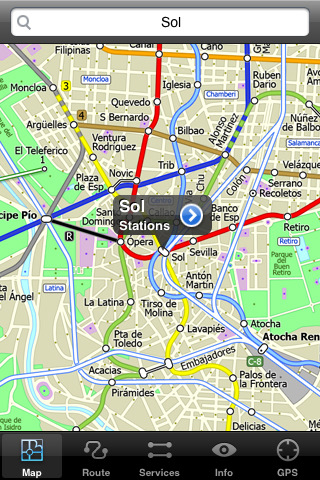
Madrid Metro by Zuti - The new Madrid Metro 10 map makes it easy to travel in and around the city using the the Metro, Renfe Rail and Metro Ligero Rail services. Unlike old fashioned schematic style maps this product contains a geographically accurate central area showing major streets, parks and places of interest etc, allowing the user to easily get their bearings.
MAP
The map is hand drawn by Visual IT and provides a unique geographically based view of Madrid with many places of interest drawn directly on the background so you can easily get your bearings when traveling around the city. You can also use your inbuilt GPS to accurately locate and track yourself within the city centre and see the nearest transportation stop and distance to it. This is the only pubic transportation route planner with this ability.
Tap on the map for location information, use the inbuilt search feature or choose from a list of locations. Places of interest, museums, hotels, parks, restaurant, shops, hospitals, streets, etc, are also included. The route planner will automatically suggest the nearest station to any place of interest you select.
MINUTE MAP
Another great feature is the “Minute Map” option which allows you to see the travel times from a start point to all other locations on the map. This is a unique way to view the topology of a city and gauge traveling times.
ROUTING
The application does not require an internet connection and will always be available to display a clear and detailed view of the city transport systems, plus list and animate the optimum route for your journey. This product provides the fastest route calculations of any mobile routing application (virtually instantaneous) using actual published journey times with the ability to select the quickest route or the route with the least changes.
· Full offline map and routing, no internet connection required.
· Colourful clear custom drawn geographically accurate mapping.
· Unique "Minute Map" feature allows quick view of all journey times from a start location.
· Services can be viewed on the map and turned on/off, routing around problems.
· Works on iPhone or iPod and in landscape or portrait mode.
· GPS location and tracking.
· Streets, Places of interest etc built into the application.
· Favourite routes can be stored and recalled.
· Access to live service information.
What's New in This Release:
· Support for retina display
· New "Measure Tool"
· Bug fix for iOS 5
What's New in 1.2:
· Added ability to view locations on a Google map.
· Icon colour change.
Like it? Share with your friends!
If you got an error while installing Themes, Software or Games, please, read FAQ.
Supported operating systems:
Apple iOS 10.x (iPad), Apple iOS 10.x (iPhone), Apple iOS 11.x (iPad), Apple iOS 12.x (iPad), Apple iOS 12.x (iPhone), Apple iOS 4.0.x (iPhone), Apple iOS 4.0.x (iPod Touch), Apple iOS 4.2.x (iPad), Apple iOS 4.2.x (iPhone), Apple iOS 4.2.x (iPod Touch), Apple iOS 4.3.x (iPad), Apple iOS 4.3.x (iPhone), Apple iOS 4.3.x (iPod Touch), Apple iOS 5.0 (iPad), Apple iOS 5.0 (iPhone), Apple iOS 5.0 (iPod Touch), Apple iOS 6.0 (iPad), Apple iOS 6.0 (iPhone), Apple iOS 6.0 (iPod Touch), Apple iOS 7.0 (iPad), Apple iOS 7.0 (iPhone), Apple iOS 7.0 (iPod Touch), Apple iOS 8.x (iPad), Apple iOS 8.x (iPhone), Apple iOS 8.x (iPod Touch), Apple iOS 9.x (iPad), Apple iOS 9.x (iPhone), Apple iOS 9.x (iPod Touch), Apple iPhone OS 3.1.x, Apple iPhone OS 3.1.x (iPod Touch), Apple iPhone OS 3.2.x (iPad)
Similar Software:
Miami Maps Miami Maps - software that helps you download and store the travel maps and plans you need. This super-handy app lets you download publicly available maps and store them on your iPhone or iPod Touch. You can download the maps when you have fast wifi connection - and then use any time in the future without delay
Lancaster London (iPhone) Lancaster London (iPhone) - There's one thing that guests at Lancaster London always seem to agree on - the views are breathtaking. With Hyde Park, the largest of the Royal Parks, directly to the south, and vistas east to the City of London, we have arguably the best views in London
Google Places Google Places with Hotpot helps you discover nearby places you'll love. Quickly search for Restaurants, Cafes, Bars and other places, while on the go.
Google Places also makes it easy to quickly rate the places you visit
Berlin Metro 09 Berlin Metro 09 - The "Berlin Metro 09" application is a superb interactive map and route planner for the Berlin Metro (U-Bahn) and Suburban rail (S Bahn) systems. You can also use your inbuilt GPS (will also work with iPod Touch devices) to accurately locate and see the nearest transportation stop and distance to it
Trip Planner Pro Trip Planner Pro - Trip Planner by GPSmyCity is a handy tool for planning your daily activities.
You can create daily itineraries for your trip, write down notes, track activities, and share your activity details with your friends. This application keeps all your travel details at your fingertips
TripDeck TripDeck - The best itinerary organizer out there – and it’s FREE. Manage your hotel reservations, car rentals, flights, cruises, restaurants, meetings and more with easy-to-read Trip Decks for each itinerary. You can also view your entire itinerary on a gorgeous map
TransitM&S Phoenix TransitM&S Phoenix - TransitM&S is an easy-to-use transit application that provides bus info for Valley Metro Transit at greater Phoenix metro area.
The app is designed for offline use. It is ideal for iPod Touch users. Even for iPhone users, it is designed to save money because AT&T no longer offers the unlimited data plan
Short Trips Around Houston Short Trips Around Houston - GPSmyCity.com's day trips and weekend getaways appliaction is a powerful tool for planning a weekend away from the city. With a well researched list of getaway spots around the city you live in, you can explore natural wonders, regional history, and small town charm within a short drive from your home
TripIt No Ads for iPhone/iPad TripIt No Ads for iPhone/iPad - TripIt is is a useful app which organizes your travel plans into an itinerary that has all the details of your trip in one place. Simply forward airline, car rental, hotel and restaurant reservations to TripIt, and you will be able to access them from anywhere
Bangkok Maps Bangkok Maps - software that helps you download and store the travel maps and plans you need. This super-handy app lets you download publicly available maps and store them on your iPhone or iPod Touch. You can download the maps when you have fast wifi connection - and then use any time in the future without delay
Other Software by developer «Visual IT»:
Tube 2 Washington Pro (UIQ) Tube 2 Washington Pro (UIQ) - This map package for Tube 2 consists of a fully scrollable detailed map of the Washington D.C. metro system and linked high quality street maps of central Washington D.C.
Plan journeys on the metro system, list details of the quickest routes and see a superb animated display of your journey tracking around the system map
Tube 2 Engine (Pocket PC) Tube 2 Engine (Pocket PC) - Transform your PDA into a fully scrollable detailed map of one of the worlds subway or metro systems.
See your journeys come alive with a superb animated display.
Save hours by automatically having the quickest routes to hand, with all the details you need including line changes, platform directions and accurate journey times
Tube 2 Berlin (UIQ3) Tube 2 Berlin (UIQ3) - This map package for Tube 2 consists of a fully scrollable detailed map of the Berlin Metro (U-Bahn/S-Bahn).
Plan journeys on this system, list details of the quickest routes and see a superb animated display of your journey tracking around the system map.
Berlin is the capital and largest city in Germany
Tube 2 New York City Pro (UIQ) Tube 2 New York City Pro (UIQ) - This map package for Tube 2 consists of a fully scrollable detailed map of the New York City MTA subway system and linked high quality street maps of Manhattan. Also included are additional reference maps of the rail systems surrounding NYC
Great Britain Rail by Zuti Great Britain Rail by Zuti - The new Great Britain Rail map makes it easy to travel in and around the country using the rail services. This application contains a geographically accurate map of the whole of Great Britain allowing you to easily view the route of any journey
Tube Milan (Series 60) Tube Milan (Series 60) - Our highly acclaimed Tube application that guides you around the metro system of Milan is now available for your Series 60 Symbian powered phone. An essential addition to your phone for locals and tourists alike.
· A detailed clear colour map of the Milan metro system fully scrollable.
· Quick find station utility
Tube 2 Amsterdam (UIQ) Tube 2 Amsterdam (UIQ) - This map package for Tube 2 consists of a fully scrollable detailed map of the Amsterdam tram & metro system.
Plan journeys on this system, list details of the quickest routes and see a superb animated display of your journey tracking around the system map
Tube 2 Chicago Pro (UIQ) Tube 2 Chicago Pro (UIQ) - This map package for Tube 2 consists of a fully scrollable detailed map of the Chicago metro & commuter rail system and linked street maps of central Chicago.
Plan journeys on the metro system, list details of the quickest routes and see a superb animated display of your journey tracking around the system map
Tube 2 Boston Pro (UIQ) Tube 2 Boston Pro (UIQ) - This map package for Tube 2 consists of a fully scrollable detailed map of the Boston metro & commuter rail system and linked street maps of central Boston.
Plan journeys on the metro system, list details of the quickest routes and see a superb animated display of your journey tracking around the system map
Tube Toronto (Palm OS) Tube Toronto (Palm OS) - An award winning and highly acclaimed Palm OS application that guides you around the subway system of Toronto. An essential addition to your Palm device for locals and tourists alike.
Tube's features include:
A detailed clear colour (or grey scale) map of the transport system fully scrollable.
Quick find station utility

")


")


")
")
")
")

")
")
")
")
")