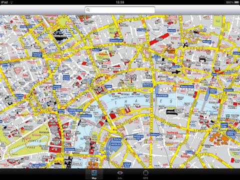
London Visitors A-Z for iPad - The London Visitors A-Z map of central London is designed especially for the tourist. The principal feature of the mapping is the highlighting of places of interest, buildings open to the public, theatres, cinemas, selected shops and stores, main shopping streets, main line and underground railway stations and other locations of interest to the visitor. Road information shown includes A and B roads, bus routes and a selection of principal minor roads.
This map is drawn by real cartographers with the detailed care and human touch of emphasis and colour that A-Z are famous for.
With the maps installed on your device there is never any need for an internet connection enabling you to access the map anywhere and at anytime. This application starts up instantly and can find any location on the map immediately. You can also use your inbuilt location services (GPS, Wifi, etc) to locate your position on the map.
Visual IT has partnered with the “Geographers A-Z Map Company” and negotiated a license to produce this map for iPad users at this very competitive price.
Add this map to one of our “Zuti” route planner maps (the classic “Zuti - London Underground” or the geographically based version “Zuti – London Tube” or if travelling by bus the “Zuti – London Bus”) and you are well equipped to travel anywhere in the central London area.
COVERAGE
The map covers an area extending from Charing Cross to:- St. John's Wood, Regent's Park, St. Pancras International Station, Shoreditch, Tower Bridge, Bermondsey, Newington, Westminster, Sloane Square, South Kensington, Earl's Court, Kensington High Street, Bayswater and Maida Vale.
· Full offline map with inbuilt search facility.
· Colourful clear custom drawn geographically accurate mapping.
· No internet connection required, no data roaming charges, works on all devices.
· GPS location and tracking.
· Streets, Places of interest, Museums and Galleries etc built into the application.
What's New in This Release:
· Latest map and data.
· Minor bug fixes.
What's New in 1.2:
· Added the ability to markup the map with points, routes and areas of interest
What's New in 1.1:
· New "Measure Tool"
· Bug fix for the next iOS release
Like it? Share with your friends!
If you got an error while installing Themes, Software or Games, please, read FAQ.
Supported operating systems:
Apple iOS 10.x (iPad), Apple iOS 11.x (iPad), Apple iOS 12.x (iPad), Apple iOS 4.2.x (iPad), Apple iOS 4.3.x (iPad), Apple iOS 5.0 (iPad), Apple iOS 6.0 (iPad), Apple iOS 7.0 (iPad), Apple iOS 8.x (iPad), Apple iOS 9.x (iPad), Apple iPhone OS 3.2.x (iPad)
Similar Software:
Cannes Walking Tours and Map This application presents you several self-guided walking tours to see the best of the city, and it comes with detailed tour route maps and powerful navigation features to guide you from one sight to the next
Barcelona Maps Offline Barcelona Maps Offline - This will be perfect when you are traveling and you don't have internet connection. This Offline Maps is not a replacement of Google Maps. It is used when you don't have internet connection and want to use maps
Marine: US East HD (From Texas to Maine) - GPS Map Navigator Marine: US East HD (From Texas to Maine) - GPS Map Navigator - FlytoMap provides complete, quick and easy to use map applications for navigation for iPad. Continues in the tradition of offering depth of information and functionality across expected places all over the world, exploring the map you get maximum details obtaining detailed information of every object on the map
Marrakech Map and Walking Tours Marrakech Map and Walking Tours - No need to hop on a tour bus or join a group; now you can explore all the best attractions on your own, at your own pace, and at a cost that is only a fraction of what you would normally pay for a guided tour
Sarasota Walking Tours and Map Sarasota Walking Tours and Map - No need to hop on a tour bus or join a group; now you can explore all the best attractions on your own, at your own pace, and at a cost that is only a fraction of what you would normally pay for a guided tour
Singapore Maps Singapore Maps - Software that helps you download and store the travel maps and plans you need. This super-handy application lets you download publicly available maps and store them on your iPhone or iPod Touch. You can download the maps when you have fast wifi connection - and then use any time in the future without delay
Oxford Offline Street Map Oxford Offline Street Map - You don't need to have internet connection for this to work as the map is stored on your iPhone or iPod Touch. Ideal for saving roaming charges or having to find the local wifi to access the built-in map application.
What's New in This Release:
· iOS 5 compatibility changes.
· Further bug fixes and improvements
Other Software by developer «Visual IT»:
Tube 2 Portland (Palm OS) Tube 2 Portland (Palm OS) - This map package for Tube 2 consists of a fully scrollable detailed map of the Portland rail system.
Plan journeys on this system, list details of the quickest routes and see a superb animated display of your journey tracking around the system map
Tube Sydney (UIQ) Tube Sydney (UIQ) - Our award winning and highly acclaimed application guides you around the Sydney rail system is now available for your Symbian UIQ phone.
An essential addition to your P800 / P900 / P910 if you travel in or around this city
· A detailed clear colour map of the Sydney rail system fully scrollable.
· Quick find station utility
Tyne & Wear Metro for iPad by Zuti Tyne & Wear Metro for iPad by Zuti - The new Tyne & Wear Metro map makes it easy to travel in and around the city using the Nexus Metro system. Unlike old fashioned schematic style maps this product contains a geographically accurate central area showing major streets, parks and places of interest etc, allowing the user to easily get their bearings
Tube Hamburg (Seris 60) Tube Hamburg (Seris 60) - Our highly acclaimed Tube application that guides you around the metro system of Hamburg is now available for your Series 60 Symbian powered phone. An essential addition to your phone for locals and tourists alike.
· A detailed clear colour map of the Hamburg metro (S-Bahn / U-Bahn) system fully scrollable
Tube Vienna (Palm OS) Tube Vienna (Palm OS) - An award winning and highly acclaimed Palm OS application that guides you around the metro system of Vienna. An essential addition to your Palm device for locals and tourists alike.
Tube's features include:
A detailed clear colour map of the Vienna metro system fully scrollable.
Quick find station utility
Tube Munich (Palm OS) Tube Munich (Palm OS) - An award winning and highly acclaimed Palm OS application that guides you around the metro (S-Bahn / U-Bahn) system of Munich. An essential addition to your Palm device for locals and tourists alike.
Tube's features include:
A detailed clear colour (or grey scale) map of the transport system fully scrollable.
Quick find station utility
Tube 2 Boston Pro (UIQ3) Tube 2 Boston Pro (UIQ3) - This map package for Tube 2 consists of a fully scrollable detailed map of the Boston metro & commuter rail system and linked street maps of central Boston.
Plan journeys on the metro system, list details of the quickest routes and see a superb animated display of your journey tracking around the system map
Tube Los Angeles (Series 60) Tube Los Angeles (Series 60) - Our highly acclaimed Tube application that guides you around the metro system of Los Angeles is now available for your Series 60 Symbian powered phone. An essential addition to your phone for locals and tourists alike.
· A detailed clear colour map of the LA metro system fully scrollable.
· Quick find station utility
Tube 2 Tokyo (UIQ) Tube 2 Tokyo (UIQ) - This map package for Tube 2 consists of a fully scrollable detailed map of the Tokyo city subway & JR rail system
Tube 2 Engine Pocket PC Tube 2 Engine - Transform your PDA into a fully scrollable detailed map of one of the worlds subway or metro systems.
See your journeys come alive with a superb animated display.
Save hours by automatically having the quickest routes to hand, with all the details you need including line changes, platform directions and accurate journey times

")


 - GPS Map Navigator")


")
")

")
")
")
")
")
")
