Buy Apple iPad Pro 12.9-inch 2020 4th gen A2229 WiFi 128GB (Apple iPad 8,11) London Underground for iPad by Zuti Application in Travel & Navigation Tag
London Underground 10 is a superb map and route planner for the London Underground, Overground and Docklands Light Railway (DLR) services. So you can make a quick exit when you leave the train we have now added exit information for all stations on the London Underground. The map and routing information is stored completely on the device and needs no internet connection, making it ideal for iPad users visiting the UK who want to avoid paying roaming charges.
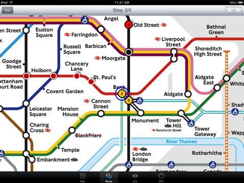
MAP
The map is the official TFL (Transport For London) map. You can use your inbuilt GPS (will also work with iPod Touch devices) to accurately locate the nearest transportation stop and distance to it. Tap on the map for location information, use the inbuilt search feature or choose from a list of locations. Places of interest, museums, hotels, parks, restaurant, shops, hospitals, streets, etc, are also included. The route planner will automatically suggest the nearest station to any place of interest you select.
MINUTE MAP
Another unique feature of is the “Minute Map” option which allows you to see the travel times from a start point to all other locations on the map. This can be very useful and is not available in any other product on the market.
INTERNET CONNECTION
The map and routing do not require an internet connection and you will not be charged data connection fees. This also means the application runs successfully underground.
ROUTING
Does not require an internet connection and will always be available to display a clear and detailed view of the city transport systems, plus list and animate the optimum route for your journey. Provides the fastest route calculations of any mobile routing application (virtually instantaneous) using actual published journey times with the ability to select the quickest route or the route with the least changes.
Comprehensive details of your planned route are provided, including changes, directions of travel, number of stops, predicted journey times, etc. Uniquely this application gives you “direction”, “towards” and “service frequency” information for each segment of the journey (not available on any other offline journey planner) for example “At Kings Cross change to the Hammersmith and City line (Eastbound) towards Barking for 3 stops. Service runs every 7 minutes” which is essential when finding the correct platform and connection. Also given are alternatives for each segment of the journey.
TRAIN + STATION EXITS
Contains simple information on every Tube station indicating what carriage to use for the most efficient exit or transfer. Just tap on a Tube station and scroll down to see the exit information for each platform.
LIVE INFO
When an internet connection is available, optional "Live Information" on the current state of the transport services can be viewed (and automatically saved for future reference) allowing you to plan your journeys in advance and avoid any potential delays. Unique to this application is the ability to turn off services that are out of action and automatically calculate an alternative route.
What's New in This Release:
· New map from TFL with the new Emirates Air Line included
· Minor routing updates
What's New in 1.7:
· Updated map and routing.
· London 2012 Olympic venues added.
What's New in 1.6:
· Latest map and routing
· Minor user interface updates
What's New in 1.5:
· Latest map from TFL
· Updated routing
· Support for retina display
· New "Measure Tool"
What's New in 1.4:
· Updated map and routes.
· Faster map loading.
· New route description text and layout.
· New "Take me home" option.
· New "Recent routes" option.
· Improved Live Info, now with departure boards.
· Various other minor updates and improvements.
What's New in 1.3:
· Minor bug fix
Like it? Share with your friends!
If you got an error while installing Themes, Software or Games, please, read FAQ.
Supported operating systems:
Apple iOS 10.x (iPad), Apple iOS 11.x (iPad), Apple iOS 12.x (iPad), Apple iOS 4.2.x (iPad), Apple iOS 4.3.x (iPad), Apple iOS 5.0 (iPad), Apple iOS 6.0 (iPad), Apple iOS 7.0 (iPad), Apple iOS 8.x (iPad), Apple iOS 9.x (iPad), Apple iPhone OS 3.2.x (iPad)
Similar Software:
TripAdvisor for iPhone/iPad TripAdvisor for iPhone/iPad - TripAdvisor is your one stop for all your travel needs. It includes reviews and advice on hotels, restaurants, resorts, flights and more
Packing Pro Packing Pro is a super-enhanced version of the popular, top-ranking Packing app
Vienna Metro 10 Vienna Metro 10 - This Zuti application contains a visually unique map of Vienna's transport systems and a superb animated journey planner to help you get around the Metro (U-Bahn), Suburban Rail (S-Bahn) and Tram (Stragenbahn)
TransitGuru Halifax The only transit app that combines with offline schedule, system maps, multiple transit types (train or bus) or agencies for single metro area, alarm to wake you up when arrival, and integration with Yelp and Map
Hong Kong Maps Hong Kong Maps - software that helps you download and store the travel maps and plans you need. This super-handy app lets you download publicly available maps and store them on your iPhone or iPod Touch. You can download the maps when you have fast wifi connection - and then use any time in the future without delay
Durgapur World Travel Durgapur World Travel - Map with locate me function makes you free to move.
Background reading always accompanies you on your trip
Tokyo Metro for iPad by Zuti Tokyo Metro for iPad by Zuti - Tokyo Metro map makes it easy to travel in and around the city using the Toei Subway, JR East routes (within the Tokyo Suburban area), Shinkansen routes, Streetcars, some important private lines and Tokyo Cruise lines
Washington Metro for iPad by Zuti The new Washington Metro 10 map makes it easy to travel in and around the city using the WMATA Metro, MARC and VME systems. Also included are the Potomac river taxi routes and the DC Circulator bus routes
Essential Long Island Essential Long Island - Follow in the footsteps of F. Scott Fitzgerald along Long Island's fabulous Gold Coast estates. Picnic among the vineyards of the region’s burgeoning wine region. Discover Long Island’s own Rodeo Drive….and designer discount outlets. Dining, museum-hopping, mansion tours—this four-season guide has it all
Wales Explorer Wales Explorer - Wales as part of the United Kingdom has long and deep links with the New World. Legendary for its connections with Avalon and other touchstones of British history, it is also marked indelibly with its now declined industrial history of shipping and mining
Other Software by developer «Visual IT»:
Tube Paris (Series 60) Tube Paris (Series 60) - Our highly acclaimed Tube application that guides you around the complex metro system of Paris is now available for your Series 60 Symbian powered phone. An essential addition to your phone for locals and tourists alike.
· A detailed clear colour map of the transport system fully scrollable.
· Quick find station utility
Tube 2 Amsterdam (UIQ) Tube 2 Amsterdam (UIQ) - This map package for Tube 2 consists of a fully scrollable detailed map of the Amsterdam tram & metro system.
Plan journeys on this system, list details of the quickest routes and see a superb animated display of your journey tracking around the system map
Tube 2 London Bus (UIQ3) Tube 2 London Bus (UIQ3) - This map package for Tube 2 consists of a fully scrollable detailed map of the central London TFL bus system.
You can now plan your bus journeys with ease, the application will list details of all the quickest routes, list alternative routes and show travel times
Digital Camera Guide (UIQ) Digital Camera Guide (UIQ) - An essential guide for anyone new to the world of digital photography. In a simple easy to read format with superb photographs it helps you to get the most from your camera and explains how many of the complicated features of your camera work.
Index of subjects covered:
- Camera Controls
Tube 2 Tokyo (UIQ3) Tube 2 Tokyo (UIQ3) - This map package for Tube 2 consists of a fully scrollable detailed map of the Tokyo city subway & JR rail system
Tube San Francisco Pro for Palm OS Tube San Francisco Pro for Palm OS - This map package for Tube 2 consists of a fully scrollable detailed map of the San Francisco metro & rail systems and linked high quality street maps of central San Francisco
Tube 2 Baltimore (UIQ3) Tube 2 Baltimore (UIQ3) - This map package for Tube 2 consists of a fully scrollable detailed map of the Baltimore metro & rail system.
Plan journeys on this system, list details of the quickest routes and see a superb animated display of your journey tracking around the system map
Rome Metro for iPad by Zuti Rome Metro for iPad by Zuti - The Zuti Rome Metro application is a superb geographically based map and route planner for the Metro, Tram, Urban and Regional rail systems. Unlike old fashioned schematic style maps this product contains a geographically accurate central area showing major streets, parks and places of interest etc, allowing the user to easily get their bearings
Tube 2 Chicago Pro (Palm OS) Tube 2 Chicago Pro (Palm OS) - This map package for Tube 2 consists of a fully scrollable detailed map of the Chicago metro & commuter rail system and linked street maps of central Chicago.
Plan journeys on the metro system, list details of the quickest routes and see a superb animated display of your journey tracking around the system map
Rough Guides Map Amsterdam Rough Guides Map Amsterdam... These guides are a series of fantastic interactive maps.
Produced in conjunction with the premier travel publisher Rough Guides.
Discover and explore Amsterdam using full colour interactive linked maps, in this simple to use PDA version of The Rough Guides Amsterdam

")


")
")
")
")
")

")

")
