Buy Apple iPad Pro 12.9-inch 2020 4th gen A2229 WiFi 128GB (Apple iPad 8,11) Great Britain Rail for iPad by Zuti Application in Travel & Navigation Tag
Great Britain Rail for iPad by Zuti - The new Great Britain Rail map makes it easy to travel in and around the country using the rail services. This application contains a geographically accurate map of the whole of Great Britain allowing you to easily view the route of any journey. The routing and map are contained within the application and no internet connection is required to use these features.
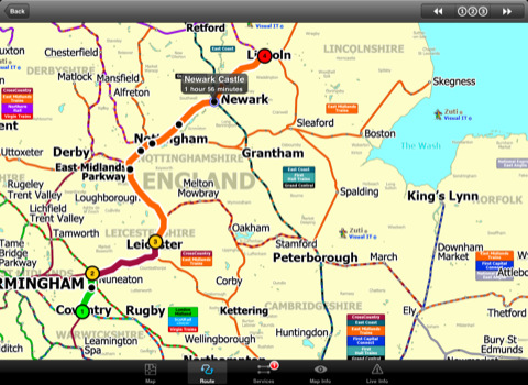
MAP
The map is hand drawn by Visual IT and provides a unique geographically based view of the Great Britain rail system. You can also use your inbuilt GPS to accurately locate and track yourself and see the nearest transportation stop and distance to it. This is the only rail transportation route planner with this ability. Tap on the map for location information, use the inbuilt search feature or choose from a list of locations.
MINUTE MAP
Another unique feature is the “Minute Map” option which allows you to see the travel times from a start point to all other locations on the map. This is a great way to view the topology of the country and gauge traveling times.
ROUTING
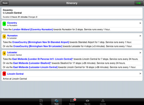
The application does not require an internet connection for routing and will always be available to display a clear and detailed view of the various rail operating company systems, plus list and animate the optimum route for your journey. This product provides the fastest route calculations of any mobile routing application using actual published journey times with the ability to select the quickest route or the route with the least changes.
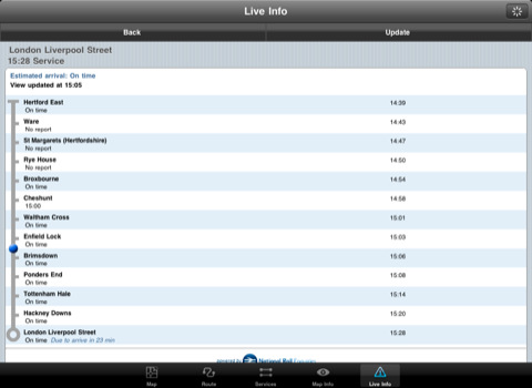
LIVE INFO
When an internet connection is available the user can check train arrivals and departures with live data supplied by National Rail Enquiries. Also shown is the estimated current real time position of the train for any of the listed services.
· The only rail app with a rail map.
· Full offline map and routing, works anywhere, no internet connection required.
· Designed for the first time visitor and experienced commuter.
· Simple, fast and intuitive to use.
· Colourful clear custom drawn geographically accurate mapping.
· Animates the route and allows tracking of the journey using GPS.
· Instantly see the route of any transport service drawn on the map.
· Save and recall favourite and recent journeys.
· One touch take me home feature.
· Unique "Minute Map" feature allows quick view of all journey times from a start location.
· Services can be turned on or off, routing round problems.
· Works on any iPad with iOS 3.2 or above.
· GPS location and tracking.
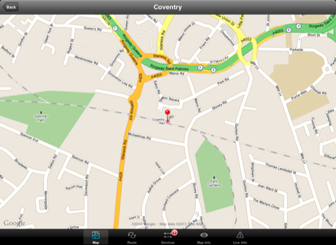
· View station locations on a Google map (internet required).
· View Live train departures and arrivals (internet required, live data supplied by National Rail Enquiries).
Like it? Share with your friends!
If you got an error while installing Themes, Software or Games, please, read FAQ.
Supported operating systems:
Apple iOS 10.x (iPad), Apple iOS 11.x (iPad), Apple iOS 12.x (iPad), Apple iOS 4.2.x (iPad), Apple iOS 4.3.x (iPad), Apple iOS 5.0 (iPad), Apple iOS 6.0 (iPad), Apple iOS 7.0 (iPad), Apple iOS 8.x (iPad), Apple iOS 9.x (iPad), Apple iPhone OS 3.2.x (iPad)
Similar Software:
easyJet for iPhone easyJet for iPhone - easyJet is the official iOS app for customers of the easyJet Airline Company. It allows users to search, book and manage flights right from their iPhone or iPod touch.
In addition, customers can track flight status, share trip information via social networks, create flight and check-in reminders, and more
Minneapolis Maps Minneapolis Maps -software that helps you download and store the travel maps and plans you need. This super-handy app lets you download publicly available maps and store them on your iPhone or iPod Touch. You can download the maps when you have fast wifi connection - and then use any time in the future without delay
Short Trips Around Houston Short Trips Around Houston - GPSmyCity.com's day trips and weekend getaways appliaction is a powerful tool for planning a weekend away from the city. With a well researched list of getaway spots around the city you live in, you can explore natural wonders, regional history, and small town charm within a short drive from your home
Travelocity for iPad Travelocity for iPad - Travelocity allows you to easily search and book flights, hotels and rental cars right from your iPad. In addition, it can save you money with exclusive deals for mobile users.
With Travelocity, you can book round-trip or one-way flights, view planned trips and itineraries, check flight status, and more
Booking.com for iPhone/iPad 5.6. Booking.com for iPhone/iPad 5.6. - Booking.com allows you to quickly find and book hotels right from your iPhone, iPad or iPod touch. The app includes a database of more than 250,000 places to stay from all over the world, along with over 17 million guest reviews and more than 2.6 million hotel photos.
With Booking
Rome Metro by Zuti Rome Metro by Zuti - The "Rome Metro" application is a superb geographically based map and route planner for the Rome Metro, Tram, Urban and Regional rail systems. This application is one in a worldwide series of Zuti maps from Visual IT who have been producing public transportation maps for mobile devices for many years
Barcelona Metro for iPad by Zuti Barcelona Metro for iPad by Zuti - This Zuti application contains a visually unique map of the Barcelona transport system and a superb animated journey planner to help you get around the TMB (Transports Metropolitan de Barcelona), FGC (Ferrocarrils de la Generalitat de Catalunya) Metro and Tram services
London City Maps Lite London City Maps Lite - software that helps you download and store the travel maps and plans you need. This super-handy app lets you download publicly available maps and store them on your iPhone or iPod Touch. You can download the maps when you have fast wifi connection - and then use any time in the future without delay
Lancaster London (iPhone) Lancaster London (iPhone) - There's one thing that guests at Lancaster London always seem to agree on - the views are breathtaking. With Hyde Park, the largest of the Royal Parks, directly to the south, and vistas east to the City of London, we have arguably the best views in London
Bookatable (iPhone/iPad) Bookatable (iPhone/iPad) - Deliciously simple reservations for every restaurant on Bookatable.com!
Find and book great restaurants in London, New York, across the UK and all over Europe. With thousands of participating restaurants there is something for everyone! New restaurants are added every day
Other Software by developer «Visual IT»:
GB Major Road Atlas (UIQ) GB Major Road Atlas (UIQ) - This map package is an essential addition to your Tube 2 maps if you drive in and around Great Britain.
This reference map gives you a clear view of all the major roads in the whole of Great Britain, you can use the quick find feature to locate any of the 30,000 + GB towns and villages in the database
Tube 2 Chicago Pro (Palm OS) Tube 2 Chicago Pro (Palm OS) - This map package for Tube 2 consists of a fully scrollable detailed map of the Chicago metro & commuter rail system and linked street maps of central Chicago.
Plan journeys on the metro system, list details of the quickest routes and see a superb animated display of your journey tracking around the system map
Rough Guide Map Amsterdam for UIQ Rough Guide Map Amsterdam for UIQ - Discover and explore Amsterdam using full colour interactive linked maps, in this simple to use PDA version of The Rough Guide Amsterdam Map.
Find all the top tourist spots and key attractions with ease, information on the city and its sights can be quickly displayed with links to photographs and map locations
Tube 2 Munich (UIQ3) Tube 2 Munich (UIQ3) - This map package for Tube 2 consists of a fully scrollable detailed map of the Munich metro, rail & tram system.
Plan journeys on this system, list details of the quickest routes and see a superb animated display of your journey tracking around the system map.
Munich is the capital city of Bavaria, the southern most German federal state
Tube Montreal (Series 60) Tube Montreal (Series 60) - Our highly acclaimed Tube application that guides you around the metro system of Montreal is now available for your Series 60 Symbian powered phone. An essential addition to your phone for locals and tourists alike.
· A detailed clear colour map of the Montreal metro system fully scrollable.
· Quick find station utility
Tube Vienna (Series 60) Tube Vienna (Series 60) - Our highly acclaimed Tube application that guides you around the metro system of Vienna is now available for your Series 60 Symbian powered phone. An essential addition to your phone for locals and tourists alike.
· A detailed clear colour map of the Vienna metro system fully scrollable.
· Quick find station utility
Tube Milan (Series 60) Tube Milan (Series 60) - Our highly acclaimed Tube application that guides you around the metro system of Milan is now available for your Series 60 Symbian powered phone. An essential addition to your phone for locals and tourists alike.
· A detailed clear colour map of the Milan metro system fully scrollable.
· Quick find station utility
Tube 2 London Streets (Palm OS) Tube 2 London Streets (Palm OS) - This map package for Tube 2 consists of a fully scrollable detailed map of the London Underground system and 9 linked A-Z street maps.
Plan journeys on the London Underground system, list details of the quickest routes and see a superb animated display of your journey tracking around the system map
Tube Chicago Pro (Palm OS) Tube Chicago Pro (Palm OS) - This award winning and highly acclaimed Palm application that guides you around the subway system of Chicago now comes in a pro version with these extra features :
A superb full colour street level map of the downtown Chicago area with a find feature that enables you to quickly find any street, place of interest or station on the map
Tube Sydney (UIQ) Tube Sydney (UIQ) - Our award winning and highly acclaimed application guides you around the Sydney rail system is now available for your Symbian UIQ phone.
An essential addition to your P800 / P900 / P910 if you travel in or around this city
· A detailed clear colour map of the Sydney rail system fully scrollable.
· Quick find station utility

")


")
")
")
")

")
")
")
")
")
")
")