Platforms: iPhone, iPad, iPod Touch, Apple iPhone OS
Categories: Travel & Navigation
Upload date: 15 Oct 12
Developer: Garmin
License: Commercial
Price: 74.99 $
Downloads: 107
Garmin Western Europe - Garmin StreetPilot Western Europe is packed full of great navigation features from Garmin, the world leader in GPS navigation. The application includes free access to real-time safety camera updates with community-generated alerts, and is the first iPhone navigation app to include photoReal images of complex junctions to help you navigate with confidence. It also includes rich mapping with detailed 3D buildings and landmarks, lane assist and many other advanced features, while remaining simple and easy to use.
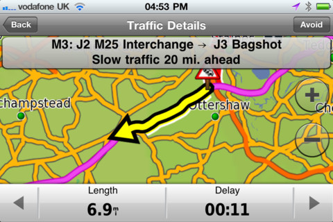
Optional in-app purchases include integrated 3D Traffic Live updates, photoLive traffic cameras and fuel pricing.
Map Coverage:
Andorra, Austria, Belgium, Corsica, Crete, Denmark, Finland, France (w/ Corsica, French Guiana, Guadeloupe, Martinique, Réunion, St. Barthélemy), Germany, Gibraltar, Greece, Guernsey, Ireland, Isle of Man, Italy (w/ Sardinia), Jersey, Liechtenstein, Luxembourg, Malta, Monaco, Netherlands, Norway, Portugal (w/ Azores Islands, Madeira), San Marino, Sardinia, Shetland Islands, Spain (w/ Canary and Balearic Islands), Sweden, Switzerland, United Kingdom
Speedwatch Safety Cameras Coverage:
Austria, Belgium, Denmark, Finland, Germany, Greece, Ireland, Italy, Luxembourg, Netherlands, Norway, Portugal, Spain, Sweden and United Kingdom
· Industry-leading Garmin user interface
· Voice-prompted, turn-by-turn directions including spoken street names
· Millions of preloaded points of interest including fuel stations, restaurants and other businesses
· Quick-search shortcuts to access your most common search terms
· Integrated Google Local Search
· Maps for Western Europe installed on your iPhone or iPad
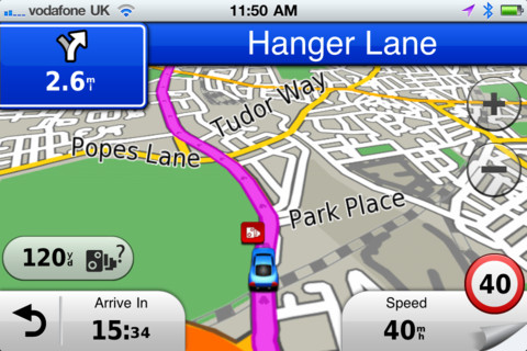
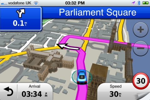
· 3D buildings and landmarks
· Lane assist with photoReal junction view provides a photo-realistic illustration of the correct lane for different maneuvers
· Integrated Speedwatch red-light and speed cameras including community-generated alerts (where available)
· Speed limits for most major roads with the capability to report speed limit changes or errors
· Where Am I? emergency locator shows your exact latitude and longitude, the nearest address and intersection, and the closest hospitals, police stations and fuel stations
· Exit services allow you to quickly see services such as restaurants, fuel stations and lodging available at exits along your route
· Trip planner allows you to create a route with multiple stops in advance with automatic or manual ordering of destinations
· Address book integration so you can easily navigate to contacts
· Trip computer includes a compass heading and bearing indicator, resettable odometer and trip statistics such as arrival distance, next turn time and average moving speed
· Trip log enables an electronic breadcrumb trail that shows you where you've been
· Weather feature shows current conditions and a 5-day forecast
· Location sharing via Facebook or SMS
What's New in This Release:
· iOS 6 and iPhone 5 support
· URBAN GUIDANCE considers public transportation options, such as subways, trams, buses and water taxis, when calculating pedestrian routes. You will be guided to a transit stop by foot and you're able to look up detailed information on what line to take and where to get off. The feature is available through In App Purchase.
· PANORAMA VIEW 3D provides true 3D elevation views obtained from NASA's height and terrain data enable intuitive orientation and show users what lies ahead. Panorama View 3D is available through In App Purchase.
· GOOGLE STREET VIEW provides users a street-level view of their destination before starting a route and shortly before arriving. Users can also look at a full-screen 360° view to get a better understanding of their destination's surroundings. The feature is available in cities with Google Street View coverage.
Like it? Share with your friends!
If you got an error while installing Themes, Software or Games, please, read FAQ.
Supported operating systems:
Apple iOS 10.x (iPad), Apple iOS 10.x (iPhone), Apple iOS 11.x (iPad), Apple iOS 12.x (iPad), Apple iOS 12.x (iPhone), Apple iOS 4.0.x (iPhone), Apple iOS 4.0.x (iPod Touch), Apple iOS 4.2.x (iPad), Apple iOS 4.2.x (iPhone), Apple iOS 4.2.x (iPod Touch), Apple iOS 4.3.x (iPad), Apple iOS 4.3.x (iPhone), Apple iOS 4.3.x (iPod Touch), Apple iOS 5.0 (iPad), Apple iOS 5.0 (iPhone), Apple iOS 5.0 (iPod Touch), Apple iOS 6.0 (iPad), Apple iOS 6.0 (iPhone), Apple iOS 6.0 (iPod Touch), Apple iOS 7.0 (iPad), Apple iOS 7.0 (iPhone), Apple iOS 7.0 (iPod Touch), Apple iOS 8.x (iPad), Apple iOS 8.x (iPhone), Apple iOS 8.x (iPod Touch), Apple iOS 9.x (iPad), Apple iOS 9.x (iPhone), Apple iOS 9.x (iPod Touch)
Similar Software:
Erie (PA, USA) Map Offline Erie (PA, USA) Map Offline - This will be perfect when you are traveling and you don't have internet connection. This Offline Maps is not a replacement of Google Maps. It is used when you don't have internet connection and want to use maps
Stuttgart (Germany) Map Offline Stuttgart (Germany) Map Offline - This will be perfect when you are traveling and you don't have internet connection. This Offline Maps is not a replacement of Google Maps. It is used when you don't have internet connection and want to use maps
CoPilot Live France CoPilot Live France - Welcome to CoPilot Live, the award winning turn-by-turn iPhone sat navigation app with complete street maps of France and door to door voice directions.
CoPilot Live is packed full of advanced navigation features to guide you easily and accurately, including clear 3D map displays, lane indicator arrows and speed limit alerts
Turkey GPS Turkey GPS is a professional Car, Bike and Pedestrian navigation system for iPhone and iPad. This system not only for Car navigation, but also for pedestrian.
· 2D and 3D navigation mode and map.
· The speed is very fast.
· Using vector map which owns small size and can zoom in any level.
· Elegant operations
Hamburg Wadden Sea National Park - GPS Map Navigator Hamburg Wadden Sea National Park - GPS Map Navigator - FlytoMap provides complete, quick and easy to use map applications for navigation for iPhone. Continues in the tradition of offering depth of information and functionality across expected places all over the world, exploring the map you get maximum details obtaining detailed information of every object on the map
Navfree GPS Live Mexico Navfree GPS Live Mexico - Navfree is a free GPS navigation solution for iOS devices. The app uses OpenStreetMap data, created and updated by thousands of users from all over the world.
The maps are stored locally on the device, so there is no need for a data connection
CoPilot Live Premium HD - USA & Canada CoPilot Live Premium HD - USA & Canada - Now there's a better way to navigate. CoPilot Live Premium HD is a new voice-guided GPS navigation app for the iPad 3G
Garmin GDL 39 Utility Garmin GDL 39 Utility - Garmin GDL 39 Utility is a companion app for the GDL 39 Portable ADS-B Receiver. It allows you to update your GDL 39 firmware using your iOS device.
The application also shows the signal strength, ground station status and battery life of GDL 39. In addition, it includes a navigation panel, which displays altimeter, heading and ground speed
Munster (Germany) Map Offline Munster (Germany) Map Offline - This will be perfect when you are traveling and you don't have internet connection. This Offline Maps is not a replacement of Google Maps. It is used when you don't have internet connection and want to use maps
Other Software by developer «Garmin»:
Whereis Navigator Whereis Navigator turns your Telstra Android device into an easy to use & full-featured GPS navigation unit, powered by Garmin and available for use in Australia only
Garmin Tracker (iPhone) Garmin Tracker (iPhone) - Brought to you by the worldwide leader in GPS, Garmin Tracker — combined with a GPS-enabled Garmin tracking device (purchase required) — lets you track what’s important while on the go.
Garmin Tracker is a free, unique application that'll help keep tabs on whatever's important to you
Garmin Indonesia Garmin Indonesia - Garmin StreetPilot is a powerful GPS navigation solution for iOS devices. It comes preloaded with the latest map of Indonesia.
Garmin Street offers many useful features, such as turn-by-turn directions, photo-realistic junction views, 3D buildings, exit services, speed cameras, and more
Garmin Voice Studio Garmin Voice Studio - Customize your Garmin-Asus phone with turn-by-turn voice directions from family and friends.
Easily create and edit Garmin navigation prompts in many languages on your phone. Share your voices with others with Garmin-Asus phones as well as Garmin nüvis.
It's a great way to add some more personality to your Android phone
Garmin Thailand Garmin Thailand - Garmin StreetPilot is a powerful GPS navigation solution for iOS devices. It comes preloaded with the latest map of Thailand.
Garmin Street offers many useful features, such as turn-by-turn directions, photo-realistic junction views, 3D buildings, exit services, speed cameras, and more
Garmin Fit for Android Garmin Fit for Android - Garmin Fit allows you to use your Android smartphone as a fitness assistant for tracking your outdoor activities. Whether you are cycling, running or simply walking, the app will show you useful information like speed, distance, route and calories burned
Garmin U.S.A. Garmin U.S.A. - Download Garmin StreetPilot Onboard U.S.A. and give your iPhone the best in GPS navigation...even when you don’t have cell coverage. Maps reside on your device, so you can look up addresses and millions of points-of-interest such as gas stations, restaurants and ATMs without needing wireless coverage
Garmin SG/MY Garmin SG/MY - Garmin StreetPilot is a powerful GPS navigation solution for iOS devices. It comes preloaded with the latest maps of Singapore, Malaysia and Brunei.
Garmin Street offers many useful features, such as turn-by-turn directions, photo-realistic junction views, 3D buildings, exit services, speed cameras, and more
Garmin Mobile for BlackBerry Garmin Mobile for BlackBerry - Turn your BlackBerry into a savvy navigator with Garmin Mobile. Includes everything you need - maps, millions of POIs and easy-to-use navigation software.
Get Premium Map Data
With spoken turn-by-turn directions that speak street names and millions of points of interest (POIs), Garmin Mobile puts robust content right at your fingertips

")


 Map Offline")

 Map Offline")


 Map Offline")


