Boston Subway for iPad by Zuti - This Boston Subway map makes it easy to travel in and around the city using the MBTA Subway, MBTA Commuter Rail, MBTA Boats, and Massport shuttle buses. Unlike old fashioned schematic style maps this product contains a geographically accurate central area showing major streets, parks and places of interest etc.
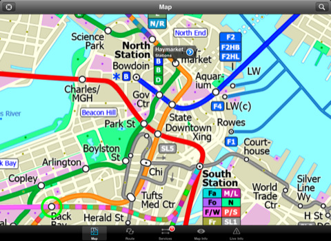
MAP
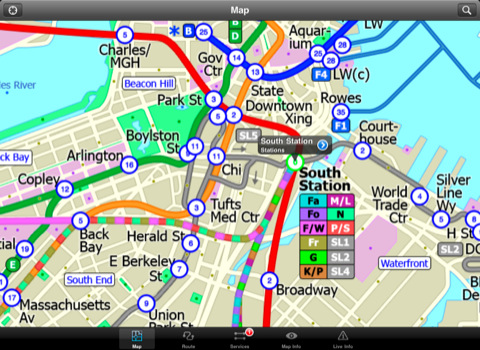
The map is hand drawn by Visual IT and provides a unique geographically based view of Boston with many places of interest drawn directly on the background so you can easily get your bearings when traveling around the city. You can also use your inbuilt GPS to accurately locate and track yourself within the city centre and see the nearest transportation stop and distance to it. This is the only public transportation route planner with this ability.
Tap on the map for location information, use the inbuilt search feature or choose from a list of locations. Places of interest, museums, hotels, parks, restaurant, shops, hospitals, streets, etc, are also included. The route planner will automatically suggest the nearest station to any place of interest you select.
MINUTE MAP
Another great feature is the “Minute Map” option which allows you to see the travel times from a start point to all other locations on the map. This is a unique way to view the topology of a city and gauge traveling times.
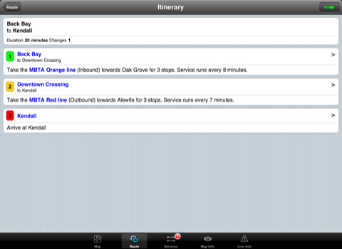
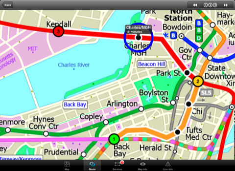
ROUTING
The application does not require an internet connection and will always be available to display a clear and detailed view of the city transport systems, plus list and animate the optimum route for your journey. This product provides the fastest route calculations of any mobile routing application (virtually instantaneous) using actual published journey times with the ability to select the quickest route or the route with the least changes.
LIVE INFO
When an internet connection is available, optional "Live Information" on the current state of the transport services can be viewed, allowing you to plan your journeys in advance and avoid any potential delays. Unique to this application is the ability to turn off services that are out of action and automatically calculate an alternative route.
· Designed for the first time visitor and experienced commuter.
· Simple, fast and intuitive to use.
· Full offline map and routing, works underground, no internet connection required.
· Animates the route and allows tracking of the journey using GPS
· Instantly see the route of any transport service drawn on the map.
· Save and recall favourite and recent journeys.
· Take me home feature.
· Unique "Minute Map" feature allows quick view of all journey times from a start location.
· Services can be turned on or off, routing round problems.
· Works in landscape or portrait mode.
· GPS location and tracking.
· Streets, Places of interest etc built into the application.
· View locations on a Google map.
· Live service status, planned disruptions, etc (internet required).
Like it? Share with your friends!
If you got an error while installing Themes, Software or Games, please, read FAQ.
Supported operating systems:
Apple iOS 10.x (iPad), Apple iOS 11.x (iPad), Apple iOS 12.x (iPad), Apple iOS 4.2.x (iPad), Apple iOS 4.3.x (iPad), Apple iOS 5.0 (iPad), Apple iOS 6.0 (iPad), Apple iOS 7.0 (iPad), Apple iOS 8.x (iPad), Apple iOS 9.x (iPad), Apple iPhone OS 3.2.x (iPad)
Similar Software:
HipGeo HipGeo is the most convenient way to track where you go, take photos, record the world around you, and tell the story about where you've been or traveled. This is a great family communication and photo sharing tool
Hotels.com for iPad Hotels.com for iPad - Hotels.com allows you to quickly find a hotel and book a room right from your iPad. The app includes a database of more than 150,000 hotels from 200 countries, complete with photos, ratings and reviews from customers.
The application allows you to search for hotels nearby or at the specified destination, and view their location on a map
Paris Metro by Zuti Paris Metro by Zuti - This Zuti application contains a visually unique map of the Paris transport system and a superb animated journey planner to help you get around the Metro, RER, SNCF, Tram, Tvm, and Vogueo services. Now revised and updated to include a larger geographic area which covers more of the outlying areas surrounding Paris
Las Vegas Maps Las Vegas Maps - software that helps you download and store the travel maps and plans you need. This super-handy app lets you download publicly available maps and store them on your iPhone or iPod Touch. You can download the maps when you have fast wifi connection - and then use any time in the future without delay
Madrid Metro by Zuti Madrid Metro by Zuti - The new Madrid Metro 10 map makes it easy to travel in and around the city using the the Metro, Renfe Rail and Metro Ligero Rail services. Unlike old fashioned schematic style maps this product contains a geographically accurate central area showing major streets, parks and places of interest etc, allowing the user to easily get their bearings
New York Subway by Zuti New York Subway by Zuti - The "New York Subway" application is a superb geographically based map and route planner for the New York public transport systems
Bremerhaven World Travel Bremerhaven World Travel - map with locate me function makes you free to move.
Background reading always accompanies you on your trip
Cold War Walking Tour in Berlin Cold War Walking Tour in Berlin - No place on Earth stood at the heart of the 20th Century conflict between the ideological poles of Communism and Capitalism like Berlin. A divided city in a divided Germany in a divided Europe in a divided world
Chicago Metro by Zuti Chicago Metro by Zuti - Chicago Metro map makes it easy to travel in and around the city using the CTA rapid transport system, the commuter services of Metrarail, Northern Indiana Commuter Transportation District and also the Water Taxi services
Beijing Subway for iPad by Zuti Beijing Subway for iPad by Zuti - Beijing Metro map makes it easy to travel in and around the city using the Beijing metro system and also includes the S2 rail line to the Great Wall at Badaling
Other Software by developer «Visual IT»:
Tube 2 Seoul (Palm OS) Tube 2 Seoul (Palm OS) - This map package for Tube 2 consists of a fully scrollable detailed map of the Seoul Metropolitan Subway system.
Plan journeys on this system, list details of the quickest routes and see a superb animated display of your journey tracking around the system map
Tube Paris Pro (2009 Edition) Tube Paris Pro
New release with GPS support.
Tube plans all your journeys for you on the Paris metro & RER systems. It gives you the quickest routes, detailed on what trains to take and in what direction plus, service running times, fare zones, ticketing information and lots more...
Tube 2 Budapest (UIQ3) Tube 2 Budapest (UIQ3) - This map package for Tube 2 consists of a fully scrollable detailed map of the Budapest metro system and HEV suburban railway.
Plan journeys on this system, list details of the quickest routes and see a superb animated display of your journey tracking around the system map
San Francisco Metro for iPad by Zuti San Francisco Metro for iPad by Zuti - The new San Francisco Metro 10 application makes it easy to travel in and around the city using the Metro (BART), Streetcar, Light Rail(MUNI), Ferry and Presidio shuttle bus services
Tube 2 Dublin (Palm OS) Tube 2 Dublin (Palm OS) - This map package for Tube 2 consists of a fully scrollable detailed map of the Dublin rail system.
Plan journeys on this system, list details of the quickest routes and see a superb animated display of your journey tracking around the system map
Tube Madrid (Series 60) Tube Madrid (Series 60) - Our highly acclaimed Tube application that guides you around the complex metro system of Madrid is now available for your Series 60 Symbian powered phone. An essential addition to your phone for locals and tourists alike.
· A detailed clear colour map of the Madrid metro system fully scrollable.
· Quick find station utility
Tube 2 Brussels (UIQ3) Tube 2 Brussels (UIQ3) - This map package for Tube 2 consists of a fully scrollable detailed map of the Brussels tram, metro & bus system.
Plan journeys on these systems, list details of the quickest routes and see a superb animated display of your journey tracking around the system map
Great Britain Rail for iPad by Zuti Great Britain Rail for iPad by Zuti - The new Great Britain Rail map makes it easy to travel in and around the country using the rail services. This application contains a geographically accurate map of the whole of Great Britain allowing you to easily view the route of any journey
Tube Munich (Series 60) Tube Munich (Series 60) - Our highly acclaimed Tube application that guides you around the complex metro system of Munich is now available for your Series 60 Symbian powered phone. An essential addition to your phone for locals and tourists alike.
· A detailed clear colour map of the Munich metro (S-Bahn/U-Bahn) system fully scrollable
Rough Guides Map Madrid Rough Guides Map Madrid... These guides are a series of fantastic interactive maps.
Produced in conjunction with the premier travel publisher Rough Guides.
Discover and explore Madrid using full colour interactive linked maps, in this simple to use PDA version of The Rough Guides Madrid

")


")
")
")

")
")
")

")
