Platforms: iPhone, iPad, iPod Touch, Apple iPhone OS
Categories: Travel & Navigation
Upload date: 30 May 13
Developer: Visual IT
License: Commercial
Price: 2.99 $
Downloads: 25
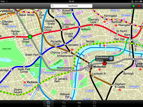
London Tube for iPad by Zuti - "London Tube 10" is a superb geographically based map and route planner for the London Underground, Overground, Docklands Light Railway (DLR), Croydon Tramlink and London Airport Express services. The map and routing information is stored completely on the device and needs no internet connection, making it ideal for iPad users visiting the UK who want to avoid paying roaming charges.
MAP
The map is hand drawn by Visual IT and provides a unique geographically based view of the city centre with many places of interest drawn directly on the background so you can easily get your bearings when traveling in and around the city. Tap on the map for location information, use the inbuilt search feature or choose from a list of locations. Places of interest, museums, hotels, parks, restaurant, shops, hospitals, streets, etc, are also included. The route planner will automatically suggest the nearest station to any place of interest you select.
MINUTE MAP
Another unique feature of is the “Minute Map” option which allows you to see the travel times from a start point to all other locations on the map. This can be very useful and is not available in any other product on the market.
INTERNET CONNECTION
The map and routing do not require an internet connection and you will not be charged data connection fees. This also means the application runs successfully underground.
ROUTING
Does not require an internet connection and will always be available to display a clear and detailed view of the city transport systems, plus list and animate the optimum route for your journey. Provides the fastest route calculations of any mobile routing application (virtually instantaneous) using actual published journey times with the ability to select the quickest route or the route with the least changes.
Comprehensive details of your planned route are provided, including changes, directions of travel, number of stops, predicted journey times, etc. Uniquely this application gives you “direction”, “towards” and “service frequency” information for each segment of the journey (not available on any other offline journey planner) for example “At Kings Cross change to the Hammersmith and City line (Eastbound) towards Barking for 3 stops. Service runs every 7 minutes” which is essential when finding the correct platform and connection. Also given are alternatives for each segment of the journey.
TRAIN + STATION EXITS
Contains simple information on every Tube station indicating what carriage to use for the most efficient exit or transfer. Just tap on a Tube station and scroll down to see the exit information for each platform.
LIVE INFO
When an internet connection is available, optional "Live Information" on the current state of the transport services can be viewed (and automatically saved for future reference) allowing you to plan your journeys in advance and avoid any potential delays. Unique to this application is the ability to turn off services that are out of action and automatically calculate an alternative route.
What's New in This Release:
· Updated map and routing
Like it? Share with your friends!
If you got an error while installing Themes, Software or Games, please, read FAQ.
Supported operating systems:
Apple iOS 10.x (iPad), Apple iOS 10.x (iPhone), Apple iOS 11.x (iPad), Apple iOS 12.x (iPad), Apple iOS 12.x (iPhone), Apple iOS 4.3.x (iPad), Apple iOS 4.3.x (iPhone), Apple iOS 4.3.x (iPod Touch), Apple iOS 5.0 (iPad), Apple iOS 5.0 (iPhone), Apple iOS 5.0 (iPod Touch), Apple iOS 6.0 (iPad), Apple iOS 6.0 (iPhone), Apple iOS 6.0 (iPod Touch), Apple iOS 7.0 (iPad), Apple iOS 7.0 (iPhone), Apple iOS 7.0 (iPod Touch), Apple iOS 8.x (iPad), Apple iOS 8.x (iPhone), Apple iOS 8.x (iPod Touch), Apple iOS 9.x (iPad), Apple iOS 9.x (iPhone), Apple iOS 9.x (iPod Touch)
Similar Software:
TransitM&S Nashville TransitM&S Nashville - TransitM&S is an easy-to-use transit application that provides bus info for Nashville's MTA.
The app is designed for offline use. It is ideal for iPod Touch users. Even for iPhone users, it is designed to save money because AT&T no longer offers the unlimited data plan
Tokyo City Maps Tokyo City Maps - software that helps you download and store the travel maps and plans you need. This super-handy app lets you download publicly available maps and store them on your iPhone or iPod Touch. You can download the maps when you have fast wifi connection - and then use any time in the future without delay
Hotels.com for iPhone Hotels.com for iPhone - Hotels.com allows you to quickly find a hotel and book a room right from your iPhone. The app includes a database of more than 150,000 hotels from 200 countries, complete with photos, ratings and reviews from customers.
The application allows you to search for hotels nearby or at the specified destination, and view their location on a map
TransitM&S Tucson TransitM&S Tucson - TransitM&S is an easy-to-use transit application that provides bus info for Sun Tran at the metro Tucson area.
The app is designed for offline use. It is ideal for iPod Touch users. Even for iPhone users, it is designed to save money because AT&T no longer offers the unlimited data plan
London Bus for iPad by Zuti London Bus for iPad by Zuti - The new Zuti London Bus map has finally arrived, making it easy to travel by bus anywhere in central London. This clear and colourful map covers a detailed street level area of 6 miles by 4 miles and includes over 1300 bus stops and 189 bus routes
Essential Long Island Essential Long Island - Follow in the footsteps of F. Scott Fitzgerald along Long Island's fabulous Gold Coast estates. Picnic among the vineyards of the region’s burgeoning wine region. Discover Long Island’s own Rodeo Drive….and designer discount outlets. Dining, museum-hopping, mansion tours—this four-season guide has it all
Trailhead for iPhone Trailhead for iPhone - The North Face Trailhead application is your one stop resource for exploration. Powered by EveryTrail.com, Trailhead finds trails, hikes, bike routes and more based on your location. You can even search by activity and length
Rome Metro 09 Rome Metro 09 - The “Rome Metro” application is a superb geographically based map and route planner for the Rome Metro, Tram, Urban and Regional rail systems. This application is one in a worldwide series of Zuti maps from Visual IT who have been producing public transportation maps for mobile devices for many years
Travelocity for iPad Travelocity for iPad - Travelocity allows you to easily search and book flights, hotels and rental cars right from your iPad. In addition, it can save you money with exclusive deals for mobile users.
With Travelocity, you can book round-trip or one-way flights, view planned trips and itineraries, check flight status, and more
Agoda for iPhone/iPad Agoda for iPhone/iPad - Smarter hotel booking just got smarter.
agoda.com - a world of hotels in the palm of your hand.
The agoda.com advantage. To go.
· Over 160,000 hotels worldwide
· 1,000,000+ hotel reviews every year
· Free stays with agoda
Other Software by developer «Visual IT»:
Great Britain Rail for iPad by Zuti Great Britain Rail for iPad by Zuti - The new Great Britain Rail map makes it easy to travel in and around the country using the rail services. This application contains a geographically accurate map of the whole of Great Britain allowing you to easily view the route of any journey
Tube 2 London (UIQ3) Tube 2 London (UIQ3) - This map package for Tube 2 consists of a fully scrollable detailed map of the London Underground system.
Plan journeys on the London Underground system, list details of the quickest routes and see a superb animated display of your journey tracking around the system map
Digital Camera Guide (UIQ) Digital Camera Guide (UIQ) - An essential guide for anyone new to the world of digital photography. In a simple easy to read format with superb photographs it helps you to get the most from your camera and explains how many of the complicated features of your camera work.
Index of subjects covered:
- Camera Controls
Tube 2 Paris (UIQ3) Tube 2 Paris (UIQ3) - This map package for Tube 2 consists of a fully scrollable detailed map of the Paris metro and RER system.
Plan journeys on this system, list details of the quickest routes and see a superb animated display of your journey tracking around the system map
Tube Singapore (UIQ) Tube Singapore (UIQ) - An award winning and highly acclaimed application that guides you around the metro system of Singapore.
An essential addition to your Sony Ericsson P800 / P900 / P910 if you travel in or around this city
· A detailed clear colour map of the Singapore metro system fully scrollable.
· Quick find station utility
Tube 2 Madrid (UIQ) Tube 2 Madrid (UIQ) - This map package for Tube 2 consists of a fully scrollable detailed map of the Madrid metro system.
Plan journeys on this system, list details of the quickest routes and see a superb animated display of your journey tracking around the system map
Chicago Metro for iPad by Zuti Chicago Metro for iPad by Zuti - Chicago Metro map makes it easy to travel in and around the city using the CTA rapid transport system, the commuter services of Metrarail, Northern Indiana Commuter Transportation District and also the Water Taxi services
Barcelona Metro for iPad by Zuti Barcelona Metro for iPad by Zuti - This Zuti application contains a visually unique map of the Barcelona transport system and a superb animated journey planner to help you get around the TMB (Transports Metropolitan de Barcelona), FGC (Ferrocarrils de la Generalitat de Catalunya) Metro and Tram services
Tube 2 Seoul (Palm OS) Tube 2 Seoul (Palm OS) - This map package for Tube 2 consists of a fully scrollable detailed map of the Seoul Metropolitan Subway system.
Plan journeys on this system, list details of the quickest routes and see a superb animated display of your journey tracking around the system map
Tube 2 Barcelona (Palm OS) Tube 2 Barcelona (Palm OS) - This map package for Tube 2 consists of a fully scrollable detailed map of the Barcelona metro & rail system.
Plan journeys on the metro system, list details of the quickest routes and see a superb animated display of your journey tracking around the system map

")


")
")
")
")
")


")
")