Platforms: iPhone, iPad, iPod Touch, Apple iPhone OS
Categories: Travel & Navigation
Upload date: 10 Oct 13
Developer: Visual IT
License: Commercial
Price: 2.99 $
Downloads: 27
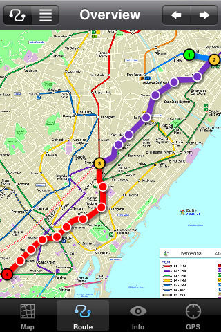
Barcelona Metro by Zuti - The Barcelona Metro application is a superb geographically based map and route planner for the Barcelona TMB (Transports Metropolitan de Barcelona) Metro and Tram services. This application is one in a worldwide series of Zuti maps from Visual IT who have been producing public transportation maps for mobile devices for many years.
MAP
The map is hand drawn by Visual IT and provides a unique geographically based view of the city with many places of interest drawn directly on the background so you can easily get your bearings when traveling in and around the city. You can also use your inbuilt GPS (can also work with iPod Touch devices) to accurately locate and track yourself within the city centre and see the nearest transportation stop and distance to it. This is the only pubic transportation route planner with this ability.
Tap on the map for location information, use the inbuilt search feature or choose from a list of locations. Places of interest, museums, hotels, parks, restaurant, shops, hospitals, streets, etc, are also included. The route planner will automatically suggest the nearest station to any place of interest you select.
NO INTERNET CONNECTION REQUIRED
The map and routing does not require an internet connection and you will not be charged data connection fees. This also means the application runs successfully underground and on an iPod Touch. The only feature that requires an internet data connection is the “Live Info” which is optional and if used only requires a small amount of data.
ROUTING
Does not require an internet connection and will always be available to display a clear and detailed view of the city transport systems, plus list and animate the optimum route for your journey. Provides the fastest route calculations of any mobile routing application (virtually instantaneous) using actual published journey times with the ability to select the quickest route or the route with the least changes.
Comprehensive details of your planned route are provided, including changes, directions of travel, number of stops, predicted journey times, etc. Uniquely this application gives you “direction”, “towards” and “service frequency” information (not available on any other offline journey planner) for example “Take the Red line (Southbound) towards 95th/Dan Ryan for 6 stops. Service runs every 7 minutes” which is essential when finding the correct platform and connection. Also given are alternatives for each leg of the journey.
What's New in This Release:
· Support for retina display
· New "Measure Tool"
· Bug fix for iOS 5
What's New in 1.4:
· Updated map and routes.
Like it? Share with your friends!
If you got an error while installing Themes, Software or Games, please, read FAQ.
Supported operating systems:
Apple iOS 10.x (iPad), Apple iOS 10.x (iPhone), Apple iOS 11.x (iPad), Apple iOS 12.x (iPad), Apple iOS 12.x (iPhone), Apple iOS 4.0.x (iPhone), Apple iOS 4.0.x (iPod Touch), Apple iOS 4.2.x (iPad), Apple iOS 4.2.x (iPhone), Apple iOS 4.2.x (iPod Touch), Apple iOS 4.3.x (iPad), Apple iOS 4.3.x (iPhone), Apple iOS 4.3.x (iPod Touch), Apple iOS 5.0 (iPad), Apple iOS 5.0 (iPhone), Apple iOS 5.0 (iPod Touch), Apple iOS 6.0 (iPad), Apple iOS 6.0 (iPhone), Apple iOS 6.0 (iPod Touch), Apple iOS 7.0 (iPad), Apple iOS 7.0 (iPhone), Apple iOS 7.0 (iPod Touch), Apple iOS 8.x (iPad), Apple iOS 8.x (iPhone), Apple iOS 8.x (iPod Touch), Apple iOS 9.x (iPad), Apple iOS 9.x (iPhone), Apple iOS 9.x (iPod Touch), Apple iPhone OS 3.1.x, Apple iPhone OS 3.1.x (iPod Touch), Apple iPhone OS 3.2.x (iPad)
Similar Software:
Trailhead for iPhone Trailhead for iPhone - The North Face Trailhead application is your one stop resource for exploration. Powered by EveryTrail.com, Trailhead finds trails, hikes, bike routes and more based on your location. You can even search by activity and length
London Tube for iPad by Zuti London Tube for iPad by Zuti - "London Tube 10" is a superb geographically based map and route planner for the London Underground, Overground, Docklands Light Railway (DLR), Croydon Tramlink and London Airport Express services
Charleroi World Travel Charleroi World Travel - Map with locate me function makes you free to move.
Background reading always accompanies you on your trip
Call a Hotel Call a Hotel - this app means you can instantly find a hotel - whenever you need it. Wherever you are in the world!
In 2 clicks you will be talking to the closest hotel to your current location.
Never get stuck for accommodation in a strange city or late at night again. Buy it for your wife, girlfriend, husband, boyfriend now! Even better - buy it for yourself
Lancaster London (iPhone) Lancaster London (iPhone) - There's one thing that guests at Lancaster London always seem to agree on - the views are breathtaking. With Hyde Park, the largest of the Royal Parks, directly to the south, and vistas east to the City of London, we have arguably the best views in London
MetrO (iPhone/iPad) MetrO (iPhone/iPad) - MetrO helps you find your way in the public transportation in more than 400 cities around the world.
One application for all your trips: download the cities you need and search your route by subway, bus, railway, tram ... (depending on cities). NO network connection is required after you have installed the cities
Denver Maps Denver Maps - Software that helps you download and store the travel maps and plans you need. This super-handy app lets you download publicly available maps and store them on your iPhone or iPod Touch. You can download the maps when you have fast wifi connection - and then use any time in the future without delay
New York Subway 10 for iPad New York Subway 10 - The “New York Subway” application is a superb geographically based map and route planner for the New York public transport systems
London Bus Free London Bus Free - The new Zuti London Bus map has finally arrived, making it easy to travel by bus anywhere in central London. This clear and colourful map covers a detailed street level area of 6 miles by 4 miles and includes over 1300 bus stops and 189 bus routes
London Underground for iPad by Zuti London Underground for iPad by Zuti - "London Underground 10" is a superb map and route planner for the London Underground, Overground and Docklands Light Railway (DLR) services. So you can make a quick exit when you leave the train we have now added exit information for all stations on the London Underground
Other Software by developer «Visual IT»:
Tube 2 Boston Pro (Palm OS) Tube 2 Boston Pro (Palm OS) - This map package for Tube 2 consists of a fully scrollable detailed map of the Boston metro & commuter rail system and linked street maps of central Boston.
Plan journeys on the metro system, list details of the quickest routes and see a superb animated display of your journey tracking around the system map
Tube 2 Hong Kong (Palm OS) Tube 2 Hong Kong (Palm OS) - This map package for Tube 2 consists of a fully scrollable detailed map of the Hong Kong metro & rail system.
Plan journeys on this system, list details of the quickest routes and see a superb animated display of your journey tracking around the system map
Tyne & Wear Metro by Zuti for iPad Tyne & Wear Metro by Zuti for iPad - The new Tyne & Wear Metro map makes it easy to travel in and around the city using the Nexus Metro system. Unlike old fashioned schematic style maps this product contains a geographically accurate central area showing major streets, parks and places of interest etc, allowing the user to easily get their bearings
Tube 2 Berlin (UIQ3) Tube 2 Berlin (UIQ3) - This map package for Tube 2 consists of a fully scrollable detailed map of the Berlin Metro (U-Bahn/S-Bahn).
Plan journeys on this system, list details of the quickest routes and see a superb animated display of your journey tracking around the system map.
Berlin is the capital and largest city in Germany
London Master A-Z for iPad London Master A-Z for iPad - This clear and colourful high quality map covers the same area as the market leading A-Z "Master Atlas of Greater London Street Atlas". The familiar look makes this by far the easiest London iPad map to use. The map is drawn by real cartographers with the detailed care and the human touch of emphasis and colour that A-Z are famous for
Tube 2 Barcelona (Palm OS) Tube 2 Barcelona (Palm OS) - This map package for Tube 2 consists of a fully scrollable detailed map of the Barcelona metro & rail system.
Plan journeys on the metro system, list details of the quickest routes and see a superb animated display of your journey tracking around the system map
Simple View Simple View - This viewer will get the best out of your palm device whether its a state of the art Hi-Res device or a simple grey scale Palm.
Its most unique & impressive feature is that you can load and view large images of virtually any size on your Palm and smoothly scroll around them zooming in/out at will. No other image viewer gives you this functionality
Tube 2 San Francisco (Palm OS) Tube 2 San Francisco (Palm OS) - This map package for Tube 2 consists of a fully scrollable detailed map of the San Francisco metro & rail systems.
The maps in this package cover the BART, SCVTA & Caltrain systems plus the Municipal Metro, Municipal Historic Street Car and Cable Car systems in central SF
Tube 2 Seoul (UIQ3) Tube 2 Seoul (UIQ3) - This map package for Tube 2 consists of a fully scrollable detailed map of the Seoul Metropolitan Subway system.
Plan journeys on this system, list details of the quickest routes and see a superb animated display of your journey tracking around the system map

")


")
")


")
")

")

")

")
")