Platforms: iPhone, iPad, iPod Touch, Apple iPhone OS
Categories: Travel & Navigation
Upload date: 15 Oct 12
Developer: Garmin
License: Commercial
Price: 49.99 $
Downloads: 45
Garmin N. America - Download Garmin StreetPilot Onboard and give your iPhone the best in GPS navigation...even when you don’t have cell coverage. Maps reside on your device, so you can look up addresses and millions of points-of-interest such as gas stations, restaurants and ATMs without needing wireless coverage. It’s as close to having a Garmin nüvi personal navigator as an iPhone or iPad can get.
Designed exclusively for your iPhone by Garmin, the world leader in GPS navigation. The Garmin StreetPilot Onboard application turns your iOS device into a premium GPS navigator with turn-by-turn voice-prompted directions that speaks street names and automatically calculates a new route if you get off track. Garmin onboard navigation offers rich mapping and many advanced features, but is still simple and intuitive to use. It includes Google Local Search in addition to several million preloaded points of interest, and also includes red-light and speed cameras powered by Speedwatch.
Map coverage:
United States, Canada, Mexico, Plus Puerto Rico, U.S. Virgin Islands, Cayman Islands, The Bahamas, French Guiana, Guadeloupe, Martinique, Saint Barthélemy, and Jamaica
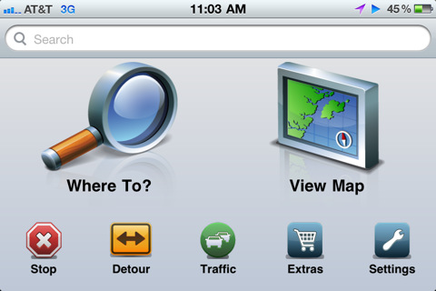
· Intuitive user interface
· Maps for North America installed on your device
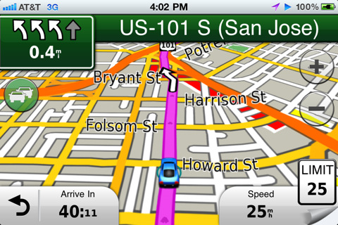
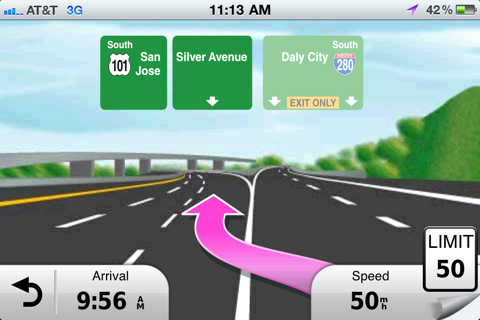
· Voice-prompted, turn-by-turn directions including street names
· Millions of preloaded points of interest including gas stations, restaurants and ATMs, along with quick-search shortcuts to access your most common search terms
· Integrated Google Local Search
· Place calls directly from search listings
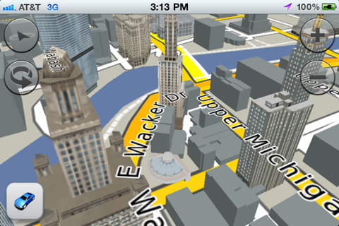
· 3-D buildings and landmarks
· Lane assist with junction view provides a photorealistic illustration of the correct lane for different maneuvers
· Integrated Speedwatch red-light and speed cameras (as available) including user-generated alerts
· Via points to enable interim stops along a route
· Detour feature for quickly calculating an alternate route
· Speed limits with alerts for most major roads
· Where Am I? emergency locator shows your exact latitude and longitude, the nearest address and intersection, and the closest hospitals, police stations and gas stations
· Exit Services allow you to quickly see services such as restaurants, gas stations, and lodging available at exits along your route
· Trip planner for creating a route with multiple stops in advance with automatic or manual ordering of destinations
· Address book integration so you can easily navigate to contacts
· Configurable vehicle icons to customize what appears on the moving map
· Configurable map data field to show arrival time, time or distance to destination, direction of travel, elevation and more
· Route overview, turns list and turn-by-turn detail available to help keep you on track
· Trip computer includes a compass heading and bearing indicator, resettable odometer trip statistics such as arrival distance, next turn time and distance, average moving speed, maximum speed, total trip time, etc.
· Trip Log enables an electronic breadcrumb trail that shows you where you've been
· Super fast map drawing and panning
· GPS navigation even when there is no cell coverage available
· Continuous navigation during an active call
· Navigate in both portrait and landscape mode
· Real-time traffic information and fuel pricing are available as optional services
What's New in This Release:
· iOS 6 and iPhone 5 support
· URBAN GUIDANCE considers public transportation options, such as subways, trams, buses and water taxis, when calculating pedestrian routes. You will be guided to a transit stop by foot and you're able to look up detailed information on what line to take and where to get off. The feature is available through In App Purchase.
· PANORAMA VIEW 3D provides true 3D elevation views obtained from NASA's height and terrain data enable intuitive orientation and show users what lies ahead. Panorama View 3D is available through In App Purchase.
· GOOGLE STREET VIEW provides users a street-level view of their destination before starting a route and shortly before arriving. Users can also look at a full-screen 360° view to get a better understanding of their destination's surroundings. The feature is available in cities with Google Street View coverage.
What's New in 2.1:
· New Map Layers feature allows users to create a unique navigation and map browsing experience by selecting the details they want to see on the map
· Traffic Notifications make it even easier to avoid incidents by highlighting events specifically on your route
· Updated NAVTEQ maps
What's New in 2.0:
· photoLive Traffic cameras allow you to keep an eye on traffic conditions along your route with live photographic images of the road ahead (available via in-app purchase)
· Weather feature shows current weather conditions and a 5 day forecast at your current location or destination
· Share locations via Facebook or SMS with friends
· All new NAVTEQ map data
Like it? Share with your friends!
If you got an error while installing Themes, Software or Games, please, read FAQ.
Supported operating systems:
Apple iOS 10.x (iPad), Apple iOS 10.x (iPhone), Apple iOS 11.x (iPad), Apple iOS 12.x (iPad), Apple iOS 12.x (iPhone), Apple iOS 4.0.x (iPhone), Apple iOS 4.0.x (iPod Touch), Apple iOS 4.2.x (iPad), Apple iOS 4.2.x (iPhone), Apple iOS 4.2.x (iPod Touch), Apple iOS 4.3.x (iPad), Apple iOS 4.3.x (iPhone), Apple iOS 4.3.x (iPod Touch), Apple iOS 5.0 (iPad), Apple iOS 5.0 (iPhone), Apple iOS 5.0 (iPod Touch), Apple iOS 6.0 (iPad), Apple iOS 6.0 (iPhone), Apple iOS 6.0 (iPod Touch), Apple iOS 7.0 (iPad), Apple iOS 7.0 (iPhone), Apple iOS 7.0 (iPod Touch), Apple iOS 8.x (iPad), Apple iOS 8.x (iPhone), Apple iOS 8.x (iPod Touch), Apple iOS 9.x (iPad), Apple iOS 9.x (iPhone), Apple iOS 9.x (iPod Touch)
Similar Software:
OpenMaps OpenMaps - Browse the maps of OpenStreetMap (OpenStreetMap, OpenCycleMap, OpenPisteMap), download them for offline use (available via in app purchase), edit the maps (tag editing and node creation), find out where you are, search for addresses, get directions and scan the map for tweets with OpenMaps for iPhone, iPod touch and iPad
Fuerth World Travel Fuerth World Travel - Map with locate me function makes you free to move.
Background reading always accompanies you on your trip
Alzburg Map Offline Alzburg Map Offline - This will be perfect when you are traveling and you don't have internet connection. This Offline Maps is not a replacement of Google Maps. It is used when you don't have internet connection and want to use maps
Saint Kitts and Nevis - GPS Map Navigator Saint Kitts and Nevis - GPS Map Navigator - FlytoMap provides complete, quick and easy to use map applications for navigation. Continues in the tradition of offering depth of information and functionality across expected places all over the world, exploring the map you get maximum details obtaining detailed information of every object on the map
Sygic Colombia: GPS Navigation Sygic Colombia: GPS Navigation - Sygic is a premium turn-by-turn GPS navigation application. Sygic boasts an intuitive interface: drag the map, pinch to zoom, change point of view using built-in compass and tap target square to choose action
Costa Rica GPS Map Costa Rica GPS Map is a navigation App for the country of Costa Rica. All application features and map data is stored within your iPhone, allowing you to use the app freely without the worry of expensive data charges. Fast, simple user interface with detailed map data allows you to navigate throughout Costa Rica using your iPhone
Munich Map Offline Munich Map Offline - This will be perfect when you are traveling and you don't have internet connection. This Offline Maps is not a replacement of Google Maps. It is used when you don't have internet connection and want to use maps
TomTom Mexico TomTom Mexico - Tap and go - Using iPhone's innovative technology, the TomTom application lets you tap your way from A to B, putting you in touch with all the best routes. Scroll through the menu, or pinch to zoom in and out on a map using the iPhone's multi-touch display.
Go your own way - Why follow the rest? See your route, your way
Terrapad Pro Terrapad Pro gives you the flexibility to enter, query, modify and export your geographic data, all from within your iPad, iPhone or iPod Touch. Driven by a powerful database engine, a unique and simple user interface, and flexible extensions, Terrapad can meet your most demanding needs.
Simple, yet powerful
Navitel Navigator (Belarus) for iPhone/iPad Navitel Navigator (Belarus) for iPhone/iPad - Navitel Navigator is a GPS travel assistant for iPhone, iPad and iPod touch. The app turns your phone into a personal navigation system
Other Software by developer «Garmin»:
Garmin Taiwan Garmin Taiwan - Garmin StreetPilot is a powerful GPS navigation solution for iOS devices. It comes preloaded with the latest map of Taiwan, including over 250,000 points of interest.
Garmin Street offers many useful features, such as turn-by-turn directions, photo-realistic junction views, 3D buildings, exit services, speed cameras, and more
Garmin Thailand Garmin Thailand - Garmin StreetPilot is a powerful GPS navigation solution for iOS devices. It comes preloaded with the latest map of Thailand.
Garmin Street offers many useful features, such as turn-by-turn directions, photo-realistic junction views, 3D buildings, exit services, speed cameras, and more
Garmin Voice Studio Garmin Voice Studio - Customize your Garmin-Asus phone with turn-by-turn voice directions from family and friends.
Easily create and edit Garmin navigation prompts in many languages on your phone. Share your voices with others with Garmin-Asus phones as well as Garmin nüvis.
It's a great way to add some more personality to your Android phone
Garmin Fit Garmin Fit - Turn your iPhone into a powerful training tool with the Garmin Fit application. See your current walking, running or cycling stats at one glance, or review and share them later thanks to automatic uploading to Garmin Connect. It even allows you select the perfect soundtrack for your workout
Garmin StreetPilot onDemand Garmin StreetPilot onDemand brings the power of Garmin navigation to your iPhone with rich navigation features for walking or driving, a simple and intuitive user interface, and an amazingly low price. Using your data connection, StreetPilot onDemand always has access to the most up-to-date maps for the U.S
Garmin China Garmin China - Garmin StreetPilot is a powerful GPS navigation solution for iOS devices. It comes preloaded with the latest maps of China, Hong Kong and Macau.
Garmin Street offers many useful features, such as turn-by-turn directions, photo-realistic junction views, 3D buildings, exit services, speed cameras, and more
Garmin Mechanic Garmin Mechanic - Get insight into how your car is performing with the free Garmin Mechanic application. Use the Skidpad to measure lateral acceleration, and track your speed and distance using GPS.
Taking a trip? Garmin Mechanic tracks your trips and calculates total distance, average speed, and estimated mileage to help increase fuel savings
Garmin Tracker (Android) Garmin Tracker (Android) - Brought to you by the worldwide leader in GPS, Garmin Tracker — combined with a GPS-enabled Garmin tracking device (purchase required) — lets you track what’s important while on the go.
Garmin Tracker is a free, unique application that will help keep tabs on whatever is important to you
Garmin Mobile for BlackBerry Garmin Mobile for BlackBerry - Turn your BlackBerry into a savvy navigator with Garmin Mobile. Includes everything you need - maps, millions of POIs and easy-to-use navigation software.
Get Premium Map Data
With spoken turn-by-turn directions that speak street names and millions of points of interest (POIs), Garmin Mobile puts robust content right at your fingertips

")


 for iPhone/iPad")


