Paris Metro 10 - This Zuti application contains a visually unique map of the Paris transport system and a superb animated journey planner to help you get around the Metro, RER, SNCF, Tram, Tvm, and Vogueo services. Now revised and updated to include a larger geographic area which covers more of the outlying areas surrounding Paris. Also newly added are SNCF train services as well as the bus services RER C, RER P, Paris par le Train Navette and Tvm.
MAP
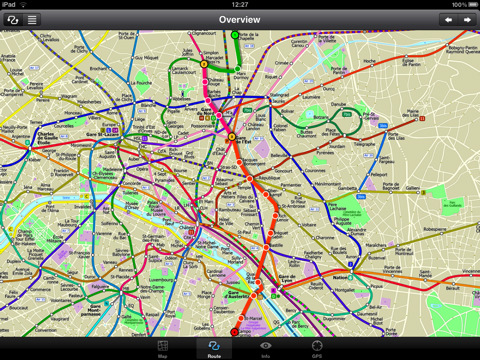
Unlike old fashioned schematic style maps this product contains a geographically accurate central area showing major streets, parks, places of interest, etc, allowing the user to easily get their bearings in the city. You can also use your inbuilt GPS to accurately locate and track yourself within the city centre and see the nearest transportation stop and distance to it. This is the only pubic transportation route planner with this ability. Tap on the map for location information, use the inbuilt search feature or choose from a list of locations. Places of interest, museums, hotels, parks, restaurant, shops, hospitals, streets, etc, are also included. The route planner will automatically suggest the nearest station to any place of interest you select. No internet connection is required for any of this functionality.
MINUTE MAP
Another great feature is the “Minute Map” option which allows you to see the travel times from a start point to all other locations on the map. This is a unique way to view the topology of a city and gauge traveling times.
ROUTING
The application does not require an internet connection and will always be available to display a clear and detailed view of the city transport systems, plus list and animate the optimum route for your journey. This product provides the fastest route calculations of any mobile routing application (virtually instantaneous) using actual published journey times with the ability to select the quickest route or the route with the least changes.
What's New in This Release:
· Completely new map and routing.
· Deep integration with inbuilt online mapping.
· Lots of new features.
· Bug fixes.
What's New in 1.3:
· New "Measure Tool"
· Bug fix for iOS 5
What's New in 1.2:
· Improved user interface.
· Save and recall favourite routes.
· Instant Minute Map from any tap location.
· Show any transport service drawn on the map.
· Minor map updates.
Like it? Share with your friends!
If you got an error while installing Themes, Software or Games, please, read FAQ.
Supported operating systems:
Apple iOS 10.x (iPad), Apple iOS 11.x (iPad), Apple iOS 12.x (iPad), Apple iOS 4.2.x (iPad), Apple iOS 4.3.x (iPad), Apple iOS 5.0 (iPad), Apple iOS 6.0 (iPad), Apple iOS 7.0 (iPad), Apple iOS 8.x (iPad), Apple iOS 9.x (iPad), Apple iPhone OS 3.2.x (iPad)
Similar Software:
Manchester Map and Walking Tours Manchester Map and Walking Tours - This Lite version of the walking tours application comes with a detailed and fully functional city map to assist you explore the city and locate sights. City map functions in this app include: street name and business (restaurants, cafes, etc
Marine: Gargano - GPS Map Navigator Marine: Gargano - GPS Map Navigator - Flytomap offers revolutionary Marine applications for iPhone, iPod Touch & iPad!!!
Go boating in the wonderful Gargano waters - discovering the bays of Gargano is an unforgettable experience.
Gorgano Marine Map contains embedded Electronic Nautical charts compressed to a large coverage
Lonely Planet Venice & The Veneto City Guide Comprehensive maps ensure you’re never lost in this vast cultural playground; detailed history, culture and language chapters give you an essential entree to local life and independent, in-depth research means you’ll never need to second guess
Rotterdam Maps Offline Rotterdam Maps Offline - This will be perfect when you are traveling and you don't have internet connection. This Offline Maps is not a replacement of Google Maps. It is used when you don't have internet connection and want to use maps
Kelowna Map Offline Kelowna Map Offline - This will be perfect when you are traveling and you don't have internet connection. This Offline Maps is not a replacement of Google Maps. It is used when you don't have internet connection and want to use maps
Guide Map New York, NY Guide Map New York, NY - This app provides you with mobile access to detailed interactive New York City maps, designed to help you enjoy the must-see attractions - the theatres, museums, galleries, shopping, architecture, historic sites, and more - that make up the New York experience
Dubai City Travel Guide With Etips City Travel Guides you have a full city guide in your iPhone or iPod touch. This tourist guide is built to be used offline. No connection to Internet required, meaning no extra charges in your phone bill!
Houston Map and Walking Tours Houston Map and Walking Tours - No need to hop on a tour bus or join a group; now you can explore all the best attractions on your own, at your own pace, and at a cost that is only a fraction of what you would normally pay for a guided tour
Other Software by developer «Visual IT»:
Tube San Francisco (Series 60) Tube San Francisco (Series 60) - Our highly acclaimed Tube application that guides you around the BART system of San Francisco is now available for your Series 60 Symbian powered phone. An essential addition to your phone for locals and tourists alike.
· A detailed clear colour map of the San Francisco BART system fully scrollable
Tyne & Wear Metro for iPad by Zuti Tyne & Wear Metro for iPad by Zuti - The new Tyne & Wear Metro map makes it easy to travel in and around the city using the Nexus Metro system. Unlike old fashioned schematic style maps this product contains a geographically accurate central area showing major streets, parks and places of interest etc, allowing the user to easily get their bearings
Tube 2 New York City (Palm OS) Tube 2 New York City (Palm OS) - This map package for Tube 2 consists of a fully scrollable detailed map of the New York City MTA subway system.
Plan journeys on this system, list details of the quickest routes and see a superb animated display of your journey tracking around the system map
Tube Philadelphia (Series 60) Tube Philadelphia (Series 60) - Our highly acclaimed Tube application that guides you around the rail system of Philadelphia is now available for your Series 60 Symbian powered phone. An essential addition to your phone for locals and tourists alike.
· A detailed clear colour map of the Philadelphia rail system fully scrollable.
· Quick find station utility
London Bus Free London Bus Free - The new Zuti London Bus map has finally arrived, making it easy to travel by bus anywhere in central London. This clear and colourful map covers a detailed street level area of 6 miles by 4 miles and includes over 1300 bus stops and 189 bus routes
Zoom Zoom - Do you sometimes struggle with the small text and graphics on your display?, then Zoom is the tool for you.
This small utility lets you instantly see a high quality bi-cubic zoomed area of any part of the display
Madrid Metro by Zuti Madrid Metro by Zuti - The new Madrid Metro 10 map makes it easy to travel in and around the city using the the Metro, Renfe Rail and Metro Ligero Rail services. Unlike old fashioned schematic style maps this product contains a geographically accurate central area showing major streets, parks and places of interest etc, allowing the user to easily get their bearings
New York Subway for iPad by Zuti New York Subway for iPad by Zuti - The "New York Subway" application is a superb geographically based map and route planner for the New York public transport systems
Tube 2 Paris Pro (UIQ) Tube 2 Paris Pro (UIQ) - This map package for Tube 2 consists of a fully scrollable detailed map of the Paris metro & RER system and linked high quality street maps of central Paris.
Plan journeys on the metro & RER system, list details of the quickest routes and see a superb animated display of your journey tracking around the system map
London Visitors A-Z London Visitors A-Z - The London Visitors Map of central London is designed especially for the tourist. The principal feature of the mapping is the highlighting of places of interest, buildings open to the public, theatres, cinemas, selected shops and stores, main shopping streets, main line and underground railway stations and other locations of interest to the visitor

")


 Street Map for iPad")


 Street Map for iPad")

")

")
")


")
