Platforms: iPhone, iPad, iPod Touch, Apple iPhone OS
Categories: Travel & Navigation
Upload date: 11 Jul 11
Developer: Visual IT
License: Commercial
Price: 4.99 $
Downloads: 21
Great Britain Rail by Zuti - The new Great Britain Rail map makes it easy to travel in and around the country using the rail services. This application contains a geographically accurate map of the whole of Great Britain allowing you to easily view the route of any journey. The routing and map are contained within the application and no internet connection is required to use these features.
MAP
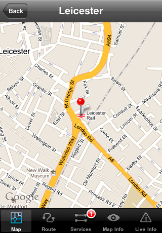
The map is hand drawn by Visual IT and provides a unique geographically based view of the Great Britain rail system. You can also use your inbuilt GPS to accurately locate and track yourself and see the nearest transportation stop and distance to it. This is the only rail transportation route planner with this ability. Tap on the map for location information, use the inbuilt search feature or choose from a list of locations.
MINUTE MAP
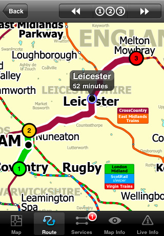
Another unique feature is the “Minute Map” option which allows you to see the travel times from a start point to all other locations on the map. This is a great way to view the topology of the country and gauge traveling times.
ROUTING
The application does not require an internet connection for routing and will always be available to display a clear and detailed view of the various rail operating company systems, plus list and animate the optimum route for your journey. This product provides the fastest route calculations of any mobile routing application using actual published journey times with the ability to select the quickest route or the route with the least changes.
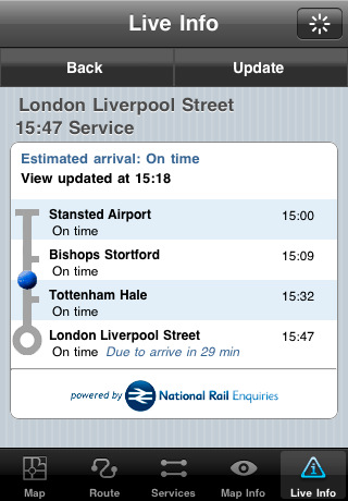
LIVE INFO
When an internet connection is available the user can check train arrivals and departures with live data supplied by National Rail Enquiries. Also shown is the estimated current real time position of the train for any of the listed services.
· The only rail app with a rail map.
· Full offline map and routing, works anywhere, no internet connection required.
· Designed for the first time visitor and experienced commuter.
· Simple, fast and intuitive to use.
· Colourful clear custom drawn geographically accurate mapping.
· Animates the route and allows tracking of the journey using GPS.
· Instantly see the route of any transport service drawn on the map.
· Save and recall favourite and recent journeys.
· One touch take me home feature.
· Unique "Minute Map" feature allows quick view of all journey times from a start location.
· Services can be turned on or off, routing round problems.
· Works on any iPhone or iPod with iOS 3.0 or above.
· GPS location and tracking.
· View station locations on a Google map (internet required).
· View Live train departures and arrivals (internet required, live data supplied by National Rail Enquiries).
Like it? Share with your friends!
If you got an error while installing Themes, Software or Games, please, read FAQ.
Supported operating systems:
Apple iOS 10.x (iPad), Apple iOS 10.x (iPhone), Apple iOS 11.x (iPad), Apple iOS 12.x (iPad), Apple iOS 12.x (iPhone), Apple iOS 4.0.x (iPhone), Apple iOS 4.0.x (iPod Touch), Apple iOS 4.2.x (iPad), Apple iOS 4.2.x (iPhone), Apple iOS 4.2.x (iPod Touch), Apple iOS 4.3.x (iPad), Apple iOS 4.3.x (iPhone), Apple iOS 4.3.x (iPod Touch), Apple iOS 5.0 (iPad), Apple iOS 5.0 (iPhone), Apple iOS 5.0 (iPod Touch), Apple iOS 6.0 (iPad), Apple iOS 6.0 (iPhone), Apple iOS 6.0 (iPod Touch), Apple iOS 7.0 (iPad), Apple iOS 7.0 (iPhone), Apple iOS 7.0 (iPod Touch), Apple iOS 8.x (iPad), Apple iOS 8.x (iPhone), Apple iOS 8.x (iPod Touch), Apple iOS 9.x (iPad), Apple iOS 9.x (iPhone), Apple iOS 9.x (iPod Touch), Apple iPhone OS 3.1.x, Apple iPhone OS 3.1.x (iPod Touch), Apple iPhone OS 3.2.x (iPad)
Similar Software:
easyJet for iPhone easyJet for iPhone - easyJet is the official iOS app for customers of the easyJet Airline Company. It allows users to search, book and manage flights right from their iPhone or iPod touch.
In addition, customers can track flight status, share trip information via social networks, create flight and check-in reminders, and more
Hong Kong Subway by Zuti Hong Kong Subway by Zuti - The new Hong Kong Metro 10 map makes it easy to travel in and around the city using the MTR transit railway, MTR light rail, MTR Airport Express, Trams, Cable Car and Ferry services
Pubs on 'n around royal mile Pubs on 'n around royal mile - GPSmyCity.com's directory guide is a powerful tool for planning your visit to a new city. Each directory guide comes with a well researched and detailed list of related attractions; such as museums, night clubs, restaurants, cafes, shops, etc. The powerful built-in navigation features provide travel directions to each venue
TripAdvisor for iPhone/iPad TripAdvisor for iPhone/iPad - TripAdvisor is your one stop for all your travel needs. It includes reviews and advice on hotels, restaurants, resorts, flights and more
Atlanta Maps Atlanta Maps - software that helps you download and store the travel maps and plans you need. This super-handy app lets you download publicly available maps and store them on your iPhone or iPod Touch. You can download the maps when you have fast wifi connection - and then use any time in the future without delay
Minneapolis Maps Minneapolis Maps - Software that helps you download and store the travel maps and plans you need. This super-handy app lets you download publicly available maps and store them on your iPhone or iPod Touch. You can download the maps when you have fast wifi connection - and then use any time in the future without delay
Dallas(Texas) World Travel Dallas(Texas) World Travel - Map with locate me function makes you free to move.
Background reading always accompanies you on your trip
Minneapolis Maps Minneapolis Maps -software that helps you download and store the travel maps and plans you need. This super-handy app lets you download publicly available maps and store them on your iPhone or iPod Touch. You can download the maps when you have fast wifi connection - and then use any time in the future without delay
London Underground for iPad by Zuti London Underground 10 is a superb map and route planner for the London Underground, Overground and Docklands Light Railway (DLR) services. So you can make a quick exit when you leave the train we have now added exit information for all stations on the London Underground
Booking.com for iPhone/iPad 6.0. Booking.com for iPhone/iPad 6.0. - Booking.com allows you to quickly find and book hotels right from your iPhone, iPad or iPod touch. The app includes a database of more than 250,000 places to stay from all over the world, along with over 17 million guest reviews and more than 2.6 million hotel photos.
With Booking
Other Software by developer «Visual IT»:
Tube 2 New York Geo (UIQ) Tube 2 New York Geo (UIQ) - This superb map package for Tube 2 is the ideal map for anyone who needs to get around New York City using the MTA subway system and would like to know just exactly where they are.
The map geographically accurately locates all of Manhattans central stations, overlaid onto a street map
GB Major Road Atlas (Palm OS) GB Major Road Atlas (Palm OS) - This map package is an essential addition to your Tube 2 maps if you drive in and around Great Britain.
This reference map gives you a clear view of all the major roads in the whole of Great Britain, you can use the quick find feature to locate any of the 30,000 + GB towns and villages in the database
Tube 2 Barcelona Pro (Palm OS) Tube 2 Barcelona Pro (Palm OS) - This map package for Tube 2 consists of a fully scrollable detailed map of the Barcelona metro & rail system and linked street maps of central Barcelona.
Plan journeys on the metro system, list details of the quickest routes and see a superb animated display of your journey tracking around the system map
Manchester Mini A-Z Manchester Mini A-Z - "Manchester Mini A-Z" is a digital rendition of the famous Geographers Company Mini A-Z Atlas for Manchester
London Tube for iPad by Zuti London Tube 10 is a superb geographically based map and route planner for the London Underground, Overground, Docklands Light Railway (DLR), Croydon Tramlink and London Airport Express services
Tube 2 Paris (Palm OS) Tube 2 Paris (Palm OS) - This map package for Tube 2 consists of a fully scrollable detailed map of the Paris metro and RER system.
Plan journeys on this system, list details of the quickest routes and see a superb animated display of your journey tracking around the system map.
A Pro version is also available with integrated high quality street maps of central Paris
Washington Metro by Zuti Washington Metro by Zuti - The new Washington Metro 10 map makes it easy to travel in and around the city using the WMATA Metro, MARC and VME systems. Also included are the Potomac river taxi routes and the DC Circulator bus routes
Tube 2 Miami (UIQ) Tube 2 Miami (UIQ) - This map package for Tube 2 consists of a fully scrollable detailed map of the Miami metro & rail system.
Plan journeys on this system, list details of the quickest routes and see a superb animated display of your journey tracking around the system map
London Mini A-Z for iPad London Mini A-Z for iPad - This clear and colourful high quality map is a digital rendition of the famous "London A-Z Mini Atlas" and covers an area from West Hendon in the North West to Grove Park in the South East. Add this application to you iPad and you will have instant access to all 352 pages of the London Mini A-Z printed map
Tube 2 Barcelona (UIQ) Tube 2 Barcelona (UIQ) - This map package for Tube 2 consists of a fully scrollable detailed map of the Barcelona metro & rail system.
Plan journeys on the metro system, list details of the quickest routes and see a superb animated display of your journey tracking around the system map

")


 World Travel")


")
")
")


")

")

")