London Underground 10 is a superb map and route planner for the London Underground, Overground and Docklands Light Railway (DLR) services. So you can make a quick exit when you leave the train we have now added exit information for all stations on the London Underground. The map and routing information is stored completely on the device and needs no internet connection, making it ideal for iPad users visiting the UK who want to avoid paying roaming charges.
MAP
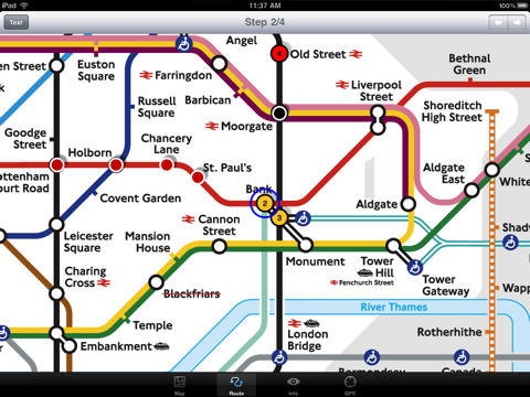
The map is the official TFL (Transport For London) map. You can use your inbuilt GPS (will also work with iPod Touch devices) to accurately locate the nearest transportation stop and distance to it. Tap on the map for location information, use the inbuilt search feature or choose from a list of locations. Places of interest, museums, hotels, parks, restaurant, shops, hospitals, streets, etc, are also included. The route planner will automatically suggest the nearest station to any place of interest you select.
MINUTE MAP
Another unique feature of is the “Minute Map” option which allows you to see the travel times from a start point to all other locations on the map. This can be very useful and is not available in any other product on the market.
INTERNET CONNECTION
The map and routing do not require an internet connection and you will not be charged data connection fees. This also means the application runs successfully underground.
ROUTING
Does not require an internet connection and will always be available to display a clear and detailed view of the city transport systems, plus list and animate the optimum route for your journey. Provides the fastest route calculations of any mobile routing application (virtually instantaneous) using actual published journey times with the ability to select the quickest route or the route with the least changes.
Comprehensive details of your planned route are provided, including changes, directions of travel, number of stops, predicted journey times, etc. Uniquely this application gives you “direction”, “towards” and “service frequency” information for each segment of the journey (not available on any other offline journey planner) for example “At Kings Cross change to the Hammersmith and City line (Eastbound) towards Barking for 3 stops. Service runs every 7 minutes” which is essential when finding the correct platform and connection. Also given are alternatives for each segment of the journey.
TRAIN + STATION EXITS
Contains simple information on every Tube station indicating what carriage to use for the most efficient exit or transfer. Just tap on a Tube station and scroll down to see the exit information for each platform.
LIVE INFO
When an internet connection is available, optional "Live Information" on the current state of the transport services can be viewed (and automatically saved for future reference) allowing you to plan your journeys in advance and avoid any potential delays. Unique to this application is the ability to turn off services that are out of action and automatically calculate an alternative route.
What's New in This Release:
· New map from TFL with the new Emirates Air Line included
· Minor routing updates
What's New in 1.7:
· Updated map and routing.
· London 2012 Olympic venues added.
What's New in 1.6:
· Latest map and routing
· Minor user interface updates
What's New in 1.5:
· Latest map from TFL
· Updated routing
· Support for retina display
· New "Measure Tool"
What's New in 1.4:
· Updated map and routes.
· Faster map loading.
· New route description text and layout.
· New "Take me home" option.
· New "Recent routes" option.
· Improved Live Info, now with departure boards.
· Various other minor updates and improvements.
What's New in 1.3:
· Minor bug fix
Like it? Share with your friends!
If you got an error while installing Themes, Software or Games, please, read FAQ.
Supported operating systems:
Apple iOS 10.x (iPad), Apple iOS 11.x (iPad), Apple iOS 12.x (iPad), Apple iOS 4.2.x (iPad), Apple iOS 4.3.x (iPad), Apple iOS 5.0 (iPad), Apple iOS 6.0 (iPad), Apple iOS 7.0 (iPad), Apple iOS 8.x (iPad), Apple iOS 9.x (iPad), Apple iPhone OS 3.2.x (iPad)
Similar Software:
Krakow (Poland) Offline Street Map Krakow (Poland) Offline Street Map - You don't need to have internet connection for this to work as the map is stored on your iPhone or iPod Touch. Ideal for saving roaming charges or having to find the local wifi to access the built-in map application.
What's New in This Release:
· iOS 5 compatibility changes.
· Further bug fixes and improvements
Innsbruck Maps Offline Innsbruck Maps Offline - This will be perfect when you are traveling and you don't have internet connection. This Offline Maps is not a replacement of Google Maps. It is used when you don't have internet connection and want to use maps
Luxembourg City Map Offline Luxembourg City Map Offline - This will be perfect when you are traveling and you don't have internet connection. This Offline Maps is not a replacement of Google Maps. It is used when you don't have internet connection and want to use maps
Tallinn Map Offline Tallinn Map Offline - This will be perfect when you are traveling and you don't have internet connection. This Offline Maps is not a replacement of Google Maps. It is used when you don't have internet connection and want to use maps
Cleveland Maps Offline Cleveland Maps Offline - This will be perfect when you are traveling and you don't have internet connection. This Offline Maps is not a replacement of Google Maps. It is used when you don't have internet connection and want to use maps
Brussels Offline Street Map Brussels Offline Street Map - You don't need to have internet connection for this to work as the map is stored on your iPhone or iPod Touch. Ideal for saving roaming charges or having to find the local wifi to access the built-in map application.
What's New in This Release:
· iOS 5 compatibility changes.
· Further bug fixes and improvements
Budapest Travel Guide - Lonely Planet Comprehensive maps ensure you're never lost in this vast cultural playground; detailed history, culture and language chapters give you an essential entree to local life and independent, in-depth research means you'll never need to second guess
Other Software by developer «Visual IT»:
Tube 2 Budapest (UIQ3) Tube 2 Budapest (UIQ3) - This map package for Tube 2 consists of a fully scrollable detailed map of the Budapest metro system and HEV suburban railway.
Plan journeys on this system, list details of the quickest routes and see a superb animated display of your journey tracking around the system map
Tube Sydney Pro (Palm OS) Tube Sydney Pro (Palm OS) - This award winning and highly acclaimed Palm application that guides you around the complex rail system of Sydney now comes in a pro version with these extra features :
A superb full colour street level map of the central Sydney area with a find feature that enables you to quickly find any street, place of interest or station on the map
London Underground for iPad by Zuti London Underground for iPad by Zuti - "London Underground 10" is a superb map and route planner for the London Underground, Overground and Docklands Light Railway (DLR) services. So you can make a quick exit when you leave the train we have now added exit information for all stations on the London Underground
London Visitors A-Z for iPad London Visitors A-Z for iPad - The London Visitors A-Z map of central London is designed especially for the tourist
Tube Munich (UIQ) Tube Munich (UIQ) - An award winning and highly acclaimed application that guides you around the complex metro (S-Bahn / U-Bahn) system of Munich.
An essential addition to your P800 / P900 / P910 if if you travel in or around this city
· A detailed clear colour map of the Munich metro (S-Bahn / U-Bahn) system fully scrollable.
· Quick find station utility
Tube 2 Milan (UIQ3) Tube 2 Milan (UIQ3) - This map package for Tube 2 consists of a fully scrollable detailed map of the Milan metro & rail system.
Plan journeys on this system, list details of the quickest routes and see a superb animated display of your journey tracking around the system map
Simple SMS for Windows Mobile 5/6 Simple SMS for Windows Mobile 5/6 -This is our extremely popular SMS application for the Pocket PC.
Simple SMS enables you to write, send, receive and store SMS messages on your Pocket PC by connecting to your mobile phone via Bluetooth, Infra red or Cable
Tube Nottingham Streets Tube Nottingham Streets - A complete street map of central Nottingham for your Palm device using superb map tiles from the famous A-Z map company.
These maps plug directly into our new Tube engine and are a convenient replacement for your paperback A-Z. Never get lost in Nottingham again
Tube Paris (Series 60) Tube Paris (Series 60) - Our highly acclaimed Tube application that guides you around the complex metro system of Paris is now available for your Series 60 Symbian powered phone. An essential addition to your phone for locals and tourists alike.
· A detailed clear colour map of the transport system fully scrollable.
· Quick find station utility
Rough Guides Map Washington DC Rough Guides Map Washington DC... These guides are a series of fantastic interactive maps.
Produced in conjunction with the premier travel publisher Rough Guides.
Discover and explore Washington DC using full colour interactive linked maps, in this simple to use PDA version of The Rough Guides Washington DC

")


 Offline Street Map")


")
")


")
")


")
