GeoMaps provides a whole bunch of different maps for your iPad. Most of the maps are cached so that you can use them offline. It is even possible to download maps for a complete region for offline usage. GeoMaps is the perfect addition to the Map App already installed on your iPad.
Features of GeoMaps:
- Online and offline usage for maps
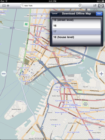
- Download of maps for offline usage
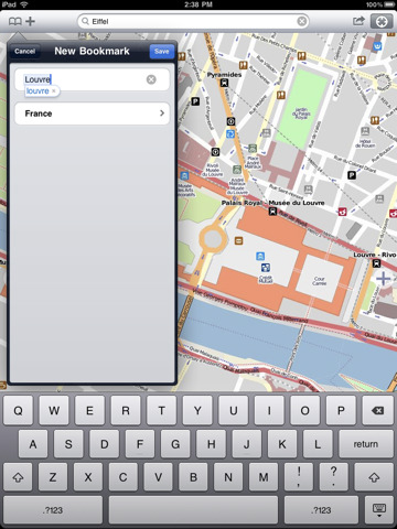
- Bookmarks
- Search
Supported Maps:
- OpenStreetMap (Mapnik)
- OpenStreetMap (Osmarender)
- Cloudmade
- OpenCycleMap
- Microsoft Bing Maps (Street)
- Microsoft Bing Maps (Satellite)
- Microsoft Bing Maps (Hybrid)
- NearMap
Like it? Share with your friends!
If you got an error while installing Themes, Software or Games, please, read FAQ.
Supported operating systems:
Apple iOS 10.x (iPad), Apple iOS 11.x (iPad), Apple iOS 12.x (iPad), Apple iOS 4.2.x (iPad), Apple iOS 4.3.x (iPad), Apple iOS 5.0 (iPad), Apple iOS 6.0 (iPad), Apple iOS 7.0 (iPad), Apple iOS 8.x (iPad), Apple iOS 9.x (iPad), Apple iPhone OS 3.2.x (iPad)
Similar Software:
Yonkers - New Rochelle (NY) Maps Offline Yonkers - New Rochelle (NY) Maps Offline - This will be perfect when you are traveling and you don't have internet connection. This Offline Maps is not a replacement of Google Maps. It is used when you don't have internet connection and want to use maps
Paris Street Map Paris Street Map - lets you find all streets, and many useful locations such as ATM's, parkings, museums, and many others. Remembers where you've been so you can find that parking spot where you left your rental car
MAPS.ME Lite for iPhone/iPad 3. MAPS.ME Lite for iPhone/iPad 3. - MapsWithMe allows you to access maps of all the countries in the world while on the go. The maps are based on OpenStreetMap data and work completely offline, without requiring an internet connection
FlyToMap GPS HD - All in One FlytoMap provides complete, quick and easy to use map applications for navigation for iPad. Continues in the tradition of offering depth of information and functionality across expected places all over the world, exploring the map you get maximum details obtaining detailed information of every object on the map
Big Bend National Park - GPS Map Navigator Big Bend National Park - GPS Map Navigator - Continues in the tradition of offering depth of information and functionality across expected places all over the world, exploring the map you get maximum details obtaining detailed information of each object on the map
Acadia National Park - GPS Map Navigator Acadia National Park - continues in the tradition of offering depth of information and functionality across expected places all over the world, exploring the map you get maximum details obtaining detailed information of each object on the map
Djerba (Tunis) - GPS Map Navigator Djerba (Tunis) - GPS Map Navigator - FlytoMap provides complete, quick and easy to use map applications for navigation for iPhone. Continues in the tradition of offering depth of information and functionality across expected places all over the world, exploring the map you get maximum details obtaining detailed information of every object on the map
Other Software by developer «Dirk Stichling»:
myTracks myTracks is not yet another GPS tracking app, but the perfect supplement for the desktop edition of myTracks for Mac OS X. GPS tracks can be recorded with both iPhone or iPod Touch and easily synchronized with your Mac. On the Mac the tracks can be organized comfortably and linked with photos of your digital camera (Geotagging)

")


 Maps Offline")


 - GPS Map Navigator")
