FlytoMap provides complete, quick and easy to use map applications for navigation for iPad. Continues in the tradition of offering depth of information and functionality across expected places all over the world, exploring the map you get maximum details obtaining detailed information of every object on the map.
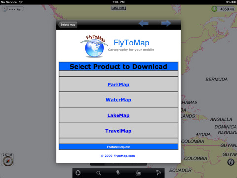
You can now buy one Application and you will be allowed to download any needed map for FREE:
- All USA Marine charts (US All, East, West, Great Lakes, Major Rivers,Florida, Texas, California, etc.)
- more than 100 US Parks and Forests
- 20 major EU parks (shortly will be 100)
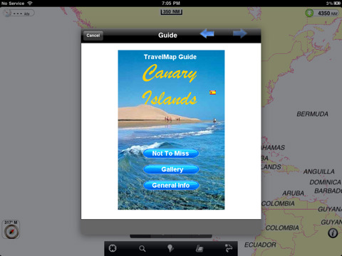
- most famous WORLD holiday areas and islands (Caribbean, Seychelles, Mauritius, Maldives, Canary Islands, Azores, Oslo Fjord, etc.)
- Lake Maps for Minnesota, Michigan, Massachusetts, Wisconsin....
FlytoMap processes different types of maps for navigation for different categories:
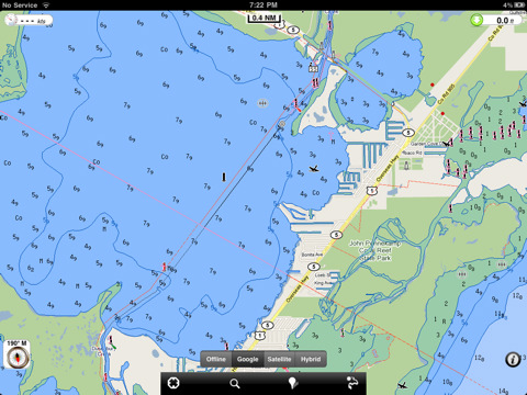
WATER MAPS (Marine):
Water map navigator is the new ‘Marine Navigator for iPhone’ contains embedded Electronic Nautical Charts (ENC) from NOAA compressed to a large coverage. You can now download the application and transform your iPhone in a chart plotter with best NOAA, ENC S57 cartography; which includes Anchoring areas, Fishing areas, restriction areas, obstructions, rocks, Buoys, Beacons, Lights, Depth contours with Values display on map, Spot Soundings and more. The only marine app available in the market with such huge information. Every effort is made to be as accurate as possible when presenting information for every destination.
PARK MAPS:
Park map applications are extremely advanced contains embedded electronic charts with all information collected from the National Park Service and local sources. The maps contain all multiple trails (Hiking, biking, Stairway trails, Bicycle trails, Equestrian trails etc.,) and Point of interests (POI) like Campgrounds, Eating places, Ranger Stations, Picnic areas, Boat/Canoe launching, Parking areas etc., which are provided depending on the relevant park areas they exist.
LAKE MAPS:
We offer high quality lake maps with detailed information and important features compressed to assure the larger coverage in USA region. Lake maps contain most important DNR lakes with detailed ‘Depth Contours, Boat Ramps, Fishing spots etc. Also includes Trails, Roads and Railways information.
TRAVEL MAPS:
These Maps treat you mostly with information of both Marine and terrain correspondingly. These are the most preferable Maps to travel especially for fascinating recreational voyages, map focus the best Beach spots along the Coast line, Major ports, Sailing, Fishing, Picnic areas, Parks, Hiking, Biking, Clubs, restaurants, Famous Hotels, Museums, Shopping areas, and much more.
· Use Latitudes and Longitudes to go to your favorite places
· Insert the target/destination ‘Waypoint’ and see in real time your speed, distance and direction to destination
· Insert Unlimited Markers near favorite places on the map
· Search your Favorite points directly
· Zoom, Rotate and Pan fast just by a finger touch
· Navigate and see your GPS position on the map
· Geo-Tagged photo management
· Set On/Off Elevation Contours if you feel data is cluttering
What's New in This Release:
New areas available:
· Lakes: Lake Champlain, Lake Mead, Lake Of the Woods, Lake Okeechobee, Lake Powell, Lake Tahoe, Lake Texoma, Lake Winnebago, Leech Lake, Mille Lacs Lake
· Marine: Netherlands, New Zealand
· Parks: Nymboi-Binderay National Park, Parque del Retiro-Madrid, Parque Eduardo VII-Lisbon, Ralambshovsparken-Stockholm, Sam Rayburn Reservoir, Schönbrunner Schloßpark-Vienna, St Stephens Green-Dublin, Stockholm, Tete d’or Park-Lyon, Toledo Bend Reservoir, Villa Borghese-Rome, Vondelpark-Amsterdam, Warandeparc-Brussels, Wellington National Park, Namadgi National Park, Villa Reale-Milan
Like it? Share with your friends!
If you got an error while installing Themes, Software or Games, please, read FAQ.
Supported operating systems:
Apple iOS 10.x (iPad), Apple iOS 11.x (iPad), Apple iOS 12.x (iPad), Apple iOS 4.2.x (iPad), Apple iOS 4.3.x (iPad), Apple iOS 5.0 (iPad), Apple iOS 6.0 (iPad), Apple iOS 7.0 (iPad), Apple iOS 8.x (iPad), Apple iOS 9.x (iPad), Apple iPhone OS 3.2.x (iPad)
Similar Software:
Bangkok Guide - Lonely Planet Comprehensive maps ensure you're never lost in this vast cultural playground; detailed history, culture and language chapters give you an essential entree to local life and independent, in-depth research means you'll never need to second guess
Dallas Street Map Offline Dallas Street Map Offline - You don't need to have internet connection for this to work as the map is stored on your iPhone or iPod Touch. Ideal for saving roaming charges or having to find the local wifi to access the built-in map application.
What's New in This Release:
· iOS 5 compatibility changes.
· Further bug fixes and improvements
Harry S Truman Reservoir - Fishing Harry S Truman Reservoir - Fishing - The Harry S Truman Dam and Reservoir features excellent fishing, hunting, camping, hiking, water sports, wildlife viewing, horseback riding and boating opportunities. Truman Lake also offers some of the best scenery in the State
FlyToMap GPS HD - All in One FlyToMap GPS HD - All in One - FlytoMap provides complete, quick and easy to use map applications for navigation for iPad. Continues in the tradition of offering depth of information and functionality across expected places all over the world, exploring the map you get maximum details obtaining detailed information of every object on the map
York (UK) Offline Street Map York (UK) Offline Street Map - You don't need to have internet connection for this to work as the map is stored on your iPhone or iPod Touch. Ideal for saving roaming charges or having to find the local wifi to access the built-in map application.
What's New in This Release:
· iOS 5 compatibility changes.
· Further bug fixes and improvements
Mesa Maps Offline Mesa Maps Offline - This will be perfect when you are traveling and you don't have internet connection. This Offline Maps is not a replacement of Google Maps. It is used when you don't have internet connection and want to use maps
Google Maps (iPhone) Google Maps (iPhone) - Google Maps is a comprehensive map solution for iOS devices. It offers accurate maps, voice guided turn-by-turn driving directions, live traffic information, public transit directions, Street View, and more.
With Google Maps, you can easily find points of interest around you, such as restaurants, pubs, shops, hotels, and more
Smart Maps - Stockholm Smart Maps - Stockholm - Smart Maps offers you an offline street level map, allowing you to search or navigate without an internet connection. Smart Maps will save you the money you pay for expensive data roaming charges or additional costs for local internet traffic.
· No internet connection required
Smart Maps - Manchester Smart Maps - Manchester - Smart Maps offers you an offline street level map, allowing you to search or navigate without an internet connection. Smart Maps will save you the money you pay for expensive data roaming charges or additional costs for local internet traffic.
· No internet connection required
Other Software by developer «Flytomap»:
Marine: Nord Adriatico (Adriatic North) - GPS Map Navigator Marine: Nord Adriatico (Adriatic North) - GPS Map Navigator - FlytoMap provides Marine applications with complete, quick and easy to use map Interface for navigation for iPhone, exploring the map you get maximum details obtaining complete information of each point on the map
Isole Pontine - GPS Map Navigator Isole Pontine - GPS Map Navigator - FlytoMap provides complete, quick and easy to use map applications for navigation. Continues in the tradition of offering depth of information and functionality across expected places all over the world, exploring the map you get maximum details obtaining detailed information of every object on the map
Eufaula Lake - Fishing Eufaula Lake - Fishing - Lake Eufaula is the largest lake located in the state of Oklahoma. Offers a variety of recreational opportunities for everyone and is a fabulous tourist attraction. The shoreline ranges from vast area of sandy beaches to rocky bluffs
Yellowstone National Park - Topo Yellowstone National Park - Topo - Continues in the tradition of offering depth of information and functionality across expected places all over the world, exploring the map you get maximum details obtaining detailed information of each object on the map
Seychelles - GPS Map Navigator Seychelles - GPS Map Navigator - FlytoMap provides complete, quick and easy to use map applications for navigation for iPhone. Continues in the tradition of offering depth of information and functionality across expected places all over the world, exploring the map you get maximum details obtaining detailed information of every object on the map
Wind NOAA Wind NOAA - realWind provides you with a wind forecast for any locations on Earth!
For kitesurfers, windsurfers, surfers, sailors, and paragliders:
· The real time observations, so you know what's going on!
· And accurate forecasts, so you can always find the best conditions for your sport!
No need to figure out your Lat, Long or Zip Code
Mount Ranier National Park - Standard Mount Ranier National Park - Standard - Continues in the tradition of offering depth of information and functionality across expected places all over the world, exploring the map you get maximum details obtaining detailed information of each object on the map
Davy Crockett National Forest - GPS Map Navigator Davy Crockett National Forest - GPS Map Navigator - Continues in the tradition of offering depth of information and functionality across expected places all over the world, exploring the map you get maximum details obtaining detailed information of each object on the map
Glacier National Park - GPS Map Navigator Glacier National Park - continues in the tradition of offering depth of information and functionality across expected places all over the world, exploring the map you get maximum details obtaining detailed information of each object on the map
real Tide HD real Tide HD - FlyToMap real tide is now available in the optimized version for iPad.
Realtime TIDE calculation at your GPS position. YES!
Our unique copyrighted algorithm is able to calculate the TIDE at any GPS location in the world thanks to 14000 stations! No need to figure out your Lat, Long or Zip Code. Your iPad figures it out for you


 Offline Street Map")

")


 - GPS Map Navigator")


