Boston Subway for iPad by Zuti - This Boston Subway map makes it easy to travel in and around the city using the MBTA Subway, MBTA Commuter Rail, MBTA Boats, and Massport shuttle buses. Unlike old fashioned schematic style maps this product contains a geographically accurate central area showing major streets, parks and places of interest etc.
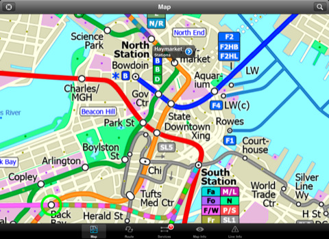
MAP
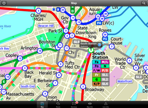
The map is hand drawn by Visual IT and provides a unique geographically based view of Boston with many places of interest drawn directly on the background so you can easily get your bearings when traveling around the city. You can also use your inbuilt GPS to accurately locate and track yourself within the city centre and see the nearest transportation stop and distance to it. This is the only public transportation route planner with this ability.
Tap on the map for location information, use the inbuilt search feature or choose from a list of locations. Places of interest, museums, hotels, parks, restaurant, shops, hospitals, streets, etc, are also included. The route planner will automatically suggest the nearest station to any place of interest you select.
MINUTE MAP
Another great feature is the “Minute Map” option which allows you to see the travel times from a start point to all other locations on the map. This is a unique way to view the topology of a city and gauge traveling times.
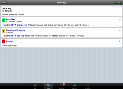
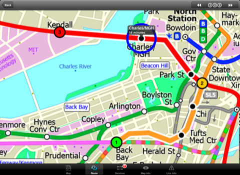
ROUTING
The application does not require an internet connection and will always be available to display a clear and detailed view of the city transport systems, plus list and animate the optimum route for your journey. This product provides the fastest route calculations of any mobile routing application (virtually instantaneous) using actual published journey times with the ability to select the quickest route or the route with the least changes.
LIVE INFO
When an internet connection is available, optional "Live Information" on the current state of the transport services can be viewed, allowing you to plan your journeys in advance and avoid any potential delays. Unique to this application is the ability to turn off services that are out of action and automatically calculate an alternative route.
· Designed for the first time visitor and experienced commuter.
· Simple, fast and intuitive to use.
· Full offline map and routing, works underground, no internet connection required.
· Animates the route and allows tracking of the journey using GPS
· Instantly see the route of any transport service drawn on the map.
· Save and recall favourite and recent journeys.
· Take me home feature.
· Unique "Minute Map" feature allows quick view of all journey times from a start location.
· Services can be turned on or off, routing round problems.
· Works in landscape or portrait mode.
· GPS location and tracking.
· Streets, Places of interest etc built into the application.
· View locations on a Google map.
· Live service status, planned disruptions, etc (internet required).
Like it? Share with your friends!
If you got an error while installing Themes, Software or Games, please, read FAQ.
Supported operating systems:
Apple iOS 10.x (iPad), Apple iOS 11.x (iPad), Apple iOS 12.x (iPad), Apple iOS 4.2.x (iPad), Apple iOS 4.3.x (iPad), Apple iOS 5.0 (iPad), Apple iOS 6.0 (iPad), Apple iOS 7.0 (iPad), Apple iOS 8.x (iPad), Apple iOS 9.x (iPad), Apple iPhone OS 3.2.x (iPad)
Similar Software:
Short Trips Around Houston Short Trips Around Houston - GPSmyCity.com's day trips and weekend getaways appliaction is a powerful tool for planning a weekend away from the city. With a well researched list of getaway spots around the city you live in, you can explore natural wonders, regional history, and small town charm within a short drive from your home
Tucson & the Old Southwest Tucson & the Old Southwest - Indian lands, Spanish colony, Mexican outpost, wild western American territory and finally the State of Arizona - the history of the lands surrounding the 'Old Pueblo' makes for fascinating diversity and exciting exploration. Saguaro-studded desert to riverine canyons to pine-topped mountains - the geography is equally as diverse
Detroit Maps Detroit Maps software that helps you download and store the travel maps and plans you need. This super-handy app lets you download publicly available maps and store them on your iPhone or iPod Touch. You can download the maps when you have fast wifi connection - and then use any time in the future without delay
Bremerhaven World Travel Bremerhaven World Travel - map with locate me function makes you free to move.
Background reading always accompanies you on your trip
Tokyo Metro for iPad by Zuti Tokyo Metro for iPad by Zuti - Tokyo Metro map makes it easy to travel in and around the city using the Toei Subway, JR East routes (within the Tokyo Suburban area), Shinkansen routes, Streetcars, some important private lines and Tokyo Cruise lines
Bus: Gold Coast Bus: Gold Coast is a friendly timetable application that provides bus timetable for Gold Coast bus transport commuters. If you need an application to keep track of your favourite bus timetables in Gold Coast then this is for you!
· Access to timetables in Gold Coast, Australia.
· Save and remove favourite routes at the touch of a button
New York Subway 10 for iPad New York Subway 10 - The “New York Subway” application is a superb geographically based map and route planner for the New York public transport systems
trivago for iPad trivago for iPad - Trivago is a hotel price comparison app for iPad. It indexes more than 100 booking sites like Booking.com, Expedia and eBookers, to show you the cheapest accommodations in over 500,000 hotels all over the world.
Finding a hotel is as easy as entering the destination and travel date
Hotels.com for iPad Hotels.com for iPad - Hotels.com allows you to quickly find a hotel and book a room right from your iPad. The app includes a database of more than 150,000 hotels from 200 countries, complete with photos, ratings and reviews from customers.
The application allows you to search for hotels nearby or at the specified destination, and view their location on a map
Southwest Airlines Southwest Airlines - Traveling with Southwest Airlines is now even more convenient with our first iPhone app. Make reservations, check in for flights, and access your Rapid Rewards account directly from your iPhone. Plus, our iPhone app has DING! functionality built in, giving you instant access to exclusive, limited-time-only air fare deals
Other Software by developer «Visual IT»:
London Underground for iPad by Zuti London Underground 10 is a superb map and route planner for the London Underground, Overground and Docklands Light Railway (DLR) services. So you can make a quick exit when you leave the train we have now added exit information for all stations on the London Underground
Tube 2 Boston (UIQ) Tube 2 Boston (UIQ) - This map package for Tube 2 consists of a fully scrollable detailed map of the Boston metro & commuter rail system.
It includes all city metro lines along with the MBTA commuter rail system and also includes the five commuter boat routes which cross the bay
Tube 2 Amsterdam Pro (UIQ3) Tube 2 Amsterdam Pro (UIQ3) - This map package for Tube 2 consists of a fully scrollable detailed map of the Amsterdam tram & metro system and linked street maps of central Amsterdam.
Plan journeys on the tram & metro system, list details of the quickest routes and see a superb animated display of your journey tracking around the system map
Tube 2 London Bus (UIQ3) Tube 2 London Bus (UIQ3) - This map package for Tube 2 consists of a fully scrollable detailed map of the central London TFL bus system.
You can now plan your bus journeys with ease, the application will list details of all the quickest routes, list alternative routes and show travel times
Tube 2 Hong Kong (UIQ) Tube 2 Hong Kong (UIQ) - This map package for Tube 2 consists of a fully scrollable detailed map of the Hong Kong metro & rail system.
Plan journeys on this system, list details of the quickest routes and see a superb animated display of your journey tracking around the system map
Tube 2 Chicago (Palm OS) Tube 2 Chicago (Palm OS) - This map package for Tube 2 consists of a fully scrollable detailed map of the Chicago metro & commuter rail system.
It includes the rapid transport system of subway and elevated lines, in addition to the many commuter rail lines. The map also indicates how the Amtrak intercity routes intersect with the cities transport network
Tube Frankfurt (Palm OS) Tube Frankfurt (Palm OS) - An award winning and highly acclaimed Palm OS application that guides you around the metro (S-Bahn / U-Bahn) system of Frankfurt. An essential addition to your Palm device for locals and tourists alike.
Tube's features include:
A detailed clear colour (or grey scale) map of the transport system fully scrollable.
Quick find station utility
Tube 2 Tokyo (Palm OS) Tube 2 Tokyo (Palm OS) - This map package for Tube 2 consists of a fully scrollable detailed map of the Tokyo city subway & JR rail system.
Plan journeys on this system, list details of the quickest routes and see a superb animated display of your journey tracking around the system map
Tube 2 Barcelona Pro (UIQ) Tube 2 Barcelona Pro (UIQ) - This map package for Tube 2 consists of a fully scrollable detailed map of the Barcelona metro & rail system and linked street maps of central Barcelona.
Plan journeys on the metro system, list details of the quickest routes and see a superb animated display of your journey tracking around the system map
Tube 2 London Touristic (UIQ) Tube 2 London Touristic (UIQ) - This map package for Tube 2 is the ideal map for the tourist or business traveller who needs to get around London using the Tube system and would like to know just exactly where they are. The map geographically locates all the central stations, making it much more informative than the official topological map


")
")
")
")
")
")
")
")
")