Vienna Metro for iPad by Zuti - The new Zuti Vienna Metro map makes it easy to travel in and around the city using the Metro (U-Bahn), Suburban Rail (S-Bahn) or Tram (Stragenbahn) systems. Unlike old fashioned schematic style maps this product contains a geographically accurate central area showing major streets, parks and places of interest etc, allowing the user to easily get their bearings.
MAP
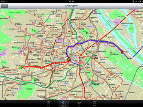
The map is hand drawn by Visual IT and provides a unique geographically based view of Vienna with many places of interest drawn directly on the background so you can easily get your bearings when traveling around the city. You can also use your inbuilt GPS to accurately locate and track yourself within the city centre and see the nearest transportation stop and distance to it. This is the only pubic transportation route planner with this ability.
Tap on the map for location information, use the inbuilt search feature or choose from a list of locations. Places of interest, museums, hotels, parks, restaurant, shops, hospitals, streets, etc, are also included. The route planner will automatically suggest the nearest station to any place of interest you select.
MINUTE MAP
Another great feature is the “Minute Map” option which allows you to see the travel times from a start point to all other locations on the map. This is a unique way to view the topology of a city and gauge traveling times.
ROUTING
The application does not require an internet connection and will always be available to display a clear and detailed view of the city transport systems, plus list and animate the optimum route for your journey. This product provides the fastest route calculations of any mobile routing application (virtually instantaneous) using actual published journey times with the ability to select the quickest route or the route with the least changes.
What's New in This Release:
· Bug fix for iOS 5
· New "Measure Tool"
Like it? Share with your friends!
If you got an error while installing Themes, Software or Games, please, read FAQ.
Supported operating systems:
Apple iOS 10.x (iPad), Apple iOS 11.x (iPad), Apple iOS 12.x (iPad), Apple iOS 4.2.x (iPad), Apple iOS 4.3.x (iPad), Apple iOS 5.0 (iPad), Apple iOS 6.0 (iPad), Apple iOS 7.0 (iPad), Apple iOS 8.x (iPad), Apple iOS 9.x (iPad), Apple iPhone OS 3.2.x (iPad)
Similar Software:
London City Maps London City Maps -software that helps you download and store the travel maps and plans you need. This super-handy app lets you download publicly available maps and store them on your iPhone or iPod Touch. You can download the maps when you have fast wifi connection - and then use any time in the future without delay
Yahoo! Sketch-a-Search Yahoo! Sketch-a-Search No keywords, or typing - just draw on your screen with your finger to identify where you want to search. You will get a bird’s eye view of your restaurant results, all conveniently located near your destination
Southwest Airlines Southwest Airlines - Traveling with Southwest Airlines is now even more convenient with our first iPhone app. Make reservations, check in for flights, and access your Rapid Rewards account directly from your iPhone. Plus, our iPhone app has DING! functionality built in, giving you instant access to exclusive, limited-time-only air fare deals
Tuscany for Foodies Tuscany for Foodies - Tuscany for Foodies introduces you to the best of foodie Tuscany, from the butchers, bakers, and cheese makers who adhere to ancient traditions and proudly sell their goods in small shops, to restaurants large and small that process local ingredients into good-to-eat meals
San Francisco Metro 10 for iPad San Francisco Metro 10 for iPad - The new San Francisco Metro 10 application makes it easy to travel in and around the city using the Metro (BART), Streetcar, Light Rail(MUNI), Ferry and Presidio shuttle bus services
Los Angeles Maps Los Angeles Maps - software that helps you download and store the travel maps and plans you need. This super-handy app lets you download publicly available maps and store them on your iPhone or iPod Touch. You can download the maps when you have fast wifi connection - and then use any time in the future without delay
New York Offline Map & Guide by Tripomatic New York Offline Map & Guide by Tripomatic - New York Offline Map & Guide by Tripomatic is a travel guide and trip planner for iPhone.
The app allows you to create your itinerary by choosing the places you want to visit.
The software comes with an offline map of New York, so you can use it even without an internet connection
CityTransit - Official NYC Subway Maps CityTransit - Official NYC Subway Maps - CityTransit uses GPS to help you find the nearest subway station and integrates with the Maps application so you can quickly get to the nearest subway station. Built-in service advisories download data from the MTA's website so you can plan your weekend trips in advance
New York Subway by Zuti New York Subway by Zuti - The "New York Subway" application is a superb geographically based map and route planner for the New York public transport systems
Up North! Grand Traverse Up North! Grand Traverse - Experience the many faces of the Grand Traverse region with this travel application from Sutro Media - Up North! Grand Traverse.
A Grand Traverse adventure can be a lot of things to different people. For some, Grand Traverse is a vast playground, ripe with opportunities for hiking and biking, camping and fishing, swimming and paddling
Other Software by developer «Visual IT»:
Tube 2 Los Angeles (Palm OS) Tube 2 Los Angeles (Palm OS) - This map package for Tube 2 consists of a fully scrollable detailed map of the Los Angeles rail system.
Plan journeys on this system, list details of the quickest routes and see a superb animated display of your journey tracking around the system map
Tube 2 Atlanta (Palm OS) Tube 2 Atlanta (Palm OS) - This map package for Tube 2 consists of a fully scrollable detailed map of the Atlanta rail system.
Plan journeys on this system, list details of the quickest routes and see a superb animated display of your journey tracking around the system map
Tube 2 Budapest (UIQ3) Tube 2 Budapest (UIQ3) - This map package for Tube 2 consists of a fully scrollable detailed map of the Budapest metro system and HEV suburban railway.
Plan journeys on this system, list details of the quickest routes and see a superb animated display of your journey tracking around the system map
Tube 2 Amsterdam (UIQ) Tube 2 Amsterdam (UIQ) - This map package for Tube 2 consists of a fully scrollable detailed map of the Amsterdam tram & metro system.
Plan journeys on this system, list details of the quickest routes and see a superb animated display of your journey tracking around the system map
Tube 2 London Touristic (UIQ) Tube 2 London Touristic (UIQ) - This map package for Tube 2 is the ideal map for the tourist or business traveller who needs to get around London using the Tube system and would like to know just exactly where they are. The map geographically locates all the central stations, making it much more informative than the official topological map
Tube 2 Rome Pro (UIQ3) Tube 2 Rome Pro (UIQ3) - This map package for Tube 2 consists of a fully scrollable detailed map of the Rome metro & rail system and linked high quality street maps of central Rome.
Plan journeys on the metro system, list details of the quickest routes and see a superb animated display of your journey tracking around the system map
Tube Vienna (Palm OS) Tube Vienna (Palm OS) - An award winning and highly acclaimed Palm OS application that guides you around the metro system of Vienna. An essential addition to your Palm device for locals and tourists alike.
Tube's features include:
A detailed clear colour map of the Vienna metro system fully scrollable.
Quick find station utility
Tube 2 Beijing Geo (Palm OS) Tube 2 Beijing Geo (Palm OS) - This superb map package for Tube 2 is the ideal map for anyone who needs to get around Beijing using the public transport system.
The map is a comprehensive map of the Beijing subway system system accurately overlaid onto an informative street map
Tube 2 Seoul (UIQ3) Tube 2 Seoul (UIQ3) - This map package for Tube 2 consists of a fully scrollable detailed map of the Seoul Metropolitan Subway system.
Plan journeys on this system, list details of the quickest routes and see a superb animated display of your journey tracking around the system map
Tube Chicago Pro (Palm OS) Tube Chicago Pro (Palm OS) - This award winning and highly acclaimed Palm application that guides you around the subway system of Chicago now comes in a pro version with these extra features :
A superb full colour street level map of the downtown Chicago area with a find feature that enables you to quickly find any street, place of interest or station on the map

")


")
")
")
")
")
")
")
")
")
")