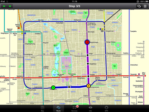
Beijing Subway for iPad by Zuti - Beijing Metro map makes it easy to travel in and around the city using the Beijing metro system and also includes the S2 rail line to the Great Wall at Badaling. Unlike old fashioned schematic style maps this product contains a geographically accurate central area showing major streets, parks and places of interest etc, allowing the user to easily get their bearings.
· Full offline map and routing, no internet connection required.
· Colourful clear custom drawn geographically accurate mapping.
· Instantly see the route of any transport service drawn on the map.
· Save and recall favorite journeys.
· Unique "Minute Map" feature allows quick view of all journey times from start location.
· Services can be turned on or off, routing round problems.
· Works on iPhone or iPod and in landscape or portrait mode.
· GPS location and tracking.
· Streets, Places of interest etc built into the application.
What's New in This Release:
· New "Measure Tool"
· Bug fix for iOS 5
What's New in 1.1:
· Updated map and routes.
· Faster map loading.
· New route description text and layout.
· New "Take me home" option.
· New "Recent routes" option.
· Various other minor updates and improvements.
Like it? Share with your friends!
If you got an error while installing Themes, Software or Games, please, read FAQ.
Supported operating systems:
Apple iOS 10.x (iPad), Apple iOS 11.x (iPad), Apple iOS 12.x (iPad), Apple iOS 4.2.x (iPad), Apple iOS 4.3.x (iPad), Apple iOS 5.0 (iPad), Apple iOS 6.0 (iPad), Apple iOS 7.0 (iPad), Apple iOS 8.x (iPad), Apple iOS 9.x (iPad), Apple iPhone OS 3.2.x (iPad)
Similar Software:
Chicago Maps Chicago Maps - This super-handy app lets you download publicly available maps and store them on your iPhone or iPod Touch. You can download the maps when you have fast wifi connection - and then use any time in the future without delay. Transit Train and Street maps, as well as tourist guides to help you around the city
HipGeo HipGeo is the most convenient way to track where you go, take photos, record the world around you, and tell the story about where you've been or traveled. This is a great family communication and photo sharing tool
TransitM&S Nashville TransitM&S Nashville - TransitM&S is an easy-to-use transit application that provides bus info for Nashville's MTA.
The app is designed for offline use. It is ideal for iPod Touch users. Even for iPhone users, it is designed to save money because AT&T no longer offers the unlimited data plan
Agoda for iPhone/iPad Agoda for iPhone/iPad - Smarter hotel booking just got smarter.
agoda.com - a world of hotels in the palm of your hand.
The agoda.com advantage. To go.
· Over 160,000 hotels worldwide
· 1,000,000+ hotel reviews every year
· Free stays with agoda
London Bus London Bus - The new Zuti London Bus map has finally arrived, making it easy to travel by bus anywhere in central London. This clear and colourful map covers a detailed street level area of 6 miles by 4 miles and includes over 1300 bus stops and 189 bus routes
TransitGuru MTA LIRR TransitGuru MTA LIRR - The ONLY rail app that offers with interactive map, offline schedule and route planning, alarm to wake you up when arrival, and integration with Yelp and Google Map.
This application is for MTA LIRR.
· Interactive system map. Tap on a station in the map to see the station info
London Underground by Zuti London Underground by Zuti - "London Underground 10" is a superb map and route planner for the London Underground, Overground and Docklands Light Railway (DLR) services. So you can make a quick exit when you leave the train we have now added exit information for all stations on the London Underground
Brooklyn Restaurant Scout Brooklyn Restaurant Scout - Brooklyn is home to the most exciting restaurant scene in the world. Way more than just the hometown of thin-crust pizza, cheesecake, and hot dogs, it's the seat of everything fresh and new in New York City's culinary world
Tube Vienna (iPhone) Tube Vienna (iPhone) is a superb interactive guide to the Vienna Metro (U-Bahn) and Vienna Tram (StrassenBahn) systems.
With no need for an internet connection Tube Vienna will always be available to display a clear and detailed view of the city transport systems, plus list and animate the optimum route for all your journeys
MetrO (iPhone/iPad) MetrO (iPhone/iPad) - MetrO helps you find your way in the public transportation in more than 400 cities around the world.
One application for all your trips: download the cities you need and search your route by subway, bus, railway, tram ... (depending on cities). NO network connection is required after you have installed the cities
Other Software by developer «Visual IT»:
London Jubilee Walkway Guide (UIQ) London Jubilee Walkway Guide (UIQ) - Essential guide to the Jubilee Walkway, London's premier walking trail. Using full colour interactive maps designed to connect the majority of London's key attractions. It is well managed, easy to follow and provides an ideal way of getting to know London
Vienna Metro by Zuti Vienna Metro by Zuti - This Zuti application contains a visually unique map of Vienna's transport systems and a superb animated journey planner to help you get around the Metro (U-Bahn), Suburban Rail (S-Bahn) and Tram (Stragenbahn)
London Tube by Zuti London Tube by Zuti - "London Tube 10" is a superb geographically based map and route planner for the London Underground, Overground, Docklands Light Railway (DLR), Croydon Tramlink and London Airport Express services. This is one in a worldwide series of Zuti maps from Visual IT who have been producing public transportation maps for mobile devices for many years
Tube Toronto (Series 60) Tube Toronto (Series 60) - Our highly acclaimed Tube application that guides you around the subway system of Toronto is now available for your Series 60 Symbian powered phone. An essential addition to your phone for locals and tourists alike.
· A detailed clear colour map of the transport system fully scrollable.
· Quick find station utility
Tube 2 Chicago Pro (UIQ3) Tube 2 Chicago Pro (UIQ3) - This map package for Tube 2 consists of a fully scrollable detailed map of the Chicago metro & commuter rail system and linked street maps of central Chicago.
Plan journeys on the metro system, list details of the quickest routes and see a superb animated display of your journey tracking around the system map
London Visitors A-Z London Visitors A-Z - The London Visitors Map of central London is designed especially for the tourist. The principal feature of the mapping is the highlighting of places of interest, buildings open to the public, theatres, cinemas, selected shops and stores, main shopping streets, main line and underground railway stations and other locations of interest to the visitor
London Central Bus 10 for iPad London Central Bus 10 for iPad - The new Zuti London Bus map has finally arrived, making it easy to travel by bus anywhere in central London. This clear and colourful map covers a detailed street level area of 6 miles by 4 miles and includes over 1300 bus stops and 189 bus routes
Tube 2 Portland (UIQ3) Tube 2 Portland (UIQ3) - This map package for Tube 2 consists of a fully scrollable detailed map of the Portland rail system.
Plan journeys on this system, list details of the quickest routes and see a superb animated display of your journey tracking around the system map
Tube 2 London Pro (Palm OS) Tube 2 London Pro (Palm OS) - This map package for Tube 2 consists of a fully scrollable detailed map of the London Underground system and 2 linked A-Z street maps.
Plan journeys on the London Underground system, list details of the quickest routes and see a superb animated display of your journey tracking around the system map
Tube 2 Tokyo (UIQ) Tube 2 Tokyo (UIQ) - This map package for Tube 2 consists of a fully scrollable detailed map of the Tokyo city subway & JR rail system

")


")
")
")


")
")


")
")
")