Platforms: iPhone, iPad, iPod Touch, Apple iPhone OS
Categories: Travel & Navigation
Upload date: 18 Jan 12
Developer: Flytomap
License: Commercial
Price: 2.99 $
Downloads: 35
Antigua - GPS Map Navigator - FlytoMap provides complete, quick and easy to use map applications for navigation for iPhone. Continues in the tradition of offering depth of information and functionality across expected places all over the world, exploring the map you get maximum details obtaining detailed information of every object on the map.
FlytoMap processes different types of maps for navigation for different categories:
WATER MAPS (Marine):
Water map navigator is the new ‘Marine Navigator for iPhone’ contains embedded Electronic Nautical Charts (ENC) from NOAA compressed to a large coverage. You can now download the application and transform your iPhone in a chart plotter with best NOAA, ENC S57 cartography; which includes Anchoring areas, Fishing areas, restriction areas, obstructions, rocks, Buoys, Beacons, Lights, Depth contours with Values display on map, Spot Soundings and more. The only marine app available in the market with such huge information. Every effort is made to be as accurate as possible when presenting information for every destination.
PARK MAPS:
Park map applications are extremely advanced contains embedded electronic charts with all information collected from the National Park Service and local sources. The maps contain all multiple trails (Hiking, biking, Stairway trails, Bicycle trails, Equestrian trails etc.,) and Point of interests (POI) like Campgrounds, Eating places, Ranger Stations, Picnic areas, Boat/Canoe launching, Parking areas etc., which are provided depending on the relevant park areas they exist.
LAKE MAPS:
We offer high quality lake maps with detailed information and important features compressed to assure the larger coverage in USA region. Lake maps contain most important DNR lakes with detailed ‘Depth Contours, Boat Ramps, Fishing spots etc. Also includes Trails, Roads and Railways information.
TRAVEL MAPS:
These Maps treat you mostly with information of both Marine and terrain correspondingly. These are the most preferable Maps to travel especially for fascinating recreational voyages, map focus the best Beach spots along the Coast line, Major ports, Sailing, Fishing, Picnic areas, Parks, Hiking, Biking, Clubs, restaurants, Famous Hotels, Museums, Shopping areas, and much more.
· Use Latitudes and Longitudes to go to your favorite places
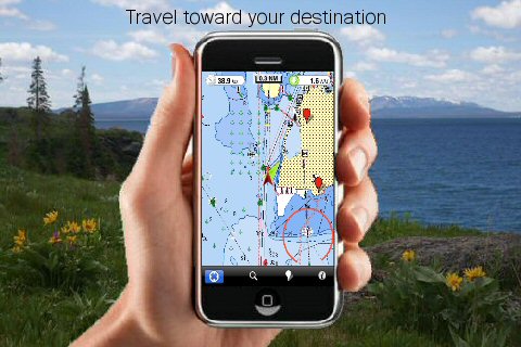
· Insert the target/destination ‘Waypoint’ and see in real time your speed, distance and direction to destination
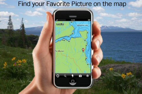
· Insert Unlimited Markers near favorite places on the map
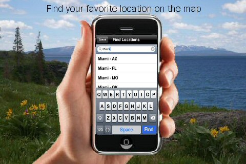
· Search your Favorite points directly
· Zoom, Rotate and Pan fast just by a finger touch
· Navigate and see your GPS position on the map
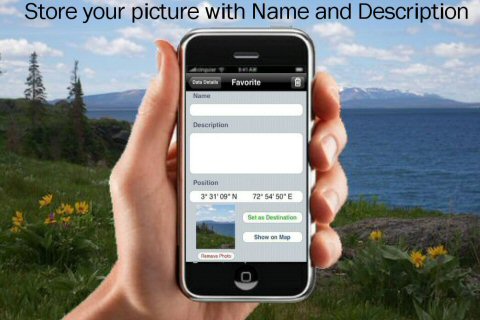
· Geo-Tagged photo management
· Set On/Off Elevation Contours if you feel data is cluttering
What's New in This Release:
· Added the link to the NOAA buoys in the application console.
What's New in 2.6:
· Minor bug fixed
· Retina display management
Like it? Share with your friends!
If you got an error while installing Themes, Software or Games, please, read FAQ.
Supported operating systems:
Apple iOS 10.x (iPad), Apple iOS 10.x (iPhone), Apple iOS 11.x (iPad), Apple iOS 12.x (iPad), Apple iOS 12.x (iPhone), Apple iOS 4.0.x (iPhone), Apple iOS 4.0.x (iPod Touch), Apple iOS 4.2.x (iPad), Apple iOS 4.2.x (iPhone), Apple iOS 4.2.x (iPod Touch), Apple iOS 4.3.x (iPad), Apple iOS 4.3.x (iPhone), Apple iOS 4.3.x (iPod Touch), Apple iOS 5.0 (iPad), Apple iOS 5.0 (iPhone), Apple iOS 5.0 (iPod Touch), Apple iOS 6.0 (iPad), Apple iOS 6.0 (iPhone), Apple iOS 6.0 (iPod Touch), Apple iOS 7.0 (iPad), Apple iOS 7.0 (iPhone), Apple iOS 7.0 (iPod Touch), Apple iOS 8.x (iPad), Apple iOS 8.x (iPhone), Apple iOS 8.x (iPod Touch), Apple iOS 9.x (iPad), Apple iOS 9.x (iPhone), Apple iOS 9.x (iPod Touch), Apple iPhone OS 3.1.x, Apple iPhone OS 3.1.x (iPod Touch), Apple iPhone OS 3.2.x (iPad)
Similar Software:
CoPilot Live Truck HD Europe CoPilot Live Truck HD Europe - Introducing CoPilot Live Truck HD: the first voice-guided satellite navigation iPad app designed specifically for drivers of HGVs, Trucks and vans.
Unlike standard car navigation applications, CoPilot Live Truck takes into account HGV-restricted and prohibited roads to provide safe, reliable navigation
Navfree GPS Live Italy Navfree GPS Live Italy - Navfree is a free GPS navigation solution for iOS devices. The app uses OpenStreetMap data, created and updated by thousands of users from all over the world.
The maps are stored locally on the device, so there is no need for a data connection
CoPilot Live Nordics CoPilot Live Nordics - Welcome to CoPilot Live, the award-winning sat navigation app that runs on your iPhone to guide you door to door with complete street maps of Norway, Sweden, Denmark and Finland.
CoPilot Live is the personal travelling assistant who's always at your side, ready to guide you to the door with turn-by-turn voice directions
Mobile Maps Algeria & Tunisia GPS Navigation Mobile Maps Algeria & Tunisia GPS Navigation - Sygic Mobile Maps is the most complete turn-by-turn, voice guided navigation software.
Maps for Algeria and Tunisia provided by NAVCITIES are with you on your mobile phone.
NAVCITIES is the leading and most reliable cartography provider for Algeria and Tunisia
Durgapur World Travel Durgapur World Travel - Map with locate me function makes you free to move.
Background reading always accompanies you on your trip
Nav4D Kuwait (LOW COST) HD Nav4D Kuwait (LOW COST) HD - The first **low cost** application!
Don't waste your money!
Why pay for lifetime if you only need it for a limited time?
Nav4D is highly innovative at a very low price.
Nav4D is a high-end GPS navigator. It brings a new look to users mobility interaction. Turn by turn directions
Allegheny National Forest - GPS Map Navigator Allegheny National Forest - GPS Map Navigator - Continues in the tradition of offering depth of information and functionality across expected places all over the world, exploring the map you get maximum details obtaining detailed information of each object on the map
Lubbock Maps Offline Lubbock Maps Offline - This will be perfect when you are traveling and you don't have internet connection. This Offline Maps is not a replacement of Google Maps. It is used when you don't have internet connection and want to use maps
Samoa - GPS Map Navigator Samoa - GPS Map Navigator - FlytoMap provides complete, quick and easy to use map applications for navigation. Continues in the tradition of offering depth of information and functionality across expected places all over the world, exploring the map you get maximum details obtaining detailed information of every object on the map
Navmii GPS Ireland HD Navmii GPS Ireland HD - Navmii is a powerful GPS navigation solution for iOS devices. The app features turn-by-turn directions, voice guidance, automatic rerouting, live Google and Microsoft Bing Search, and more.
Navmii uses offline maps which are stored locally on the device, so there is no need for a data connection
Other Software by developer «Flytomap»:
FlyToMap GPS HD - All in One FlytoMap provides complete, quick and easy to use map applications for navigation for iPad. Continues in the tradition of offering depth of information and functionality across expected places all over the world, exploring the map you get maximum details obtaining detailed information of every object on the map
Chickamauga Lake - Fishing Chickamauga Lake - Fishing - Continues in the tradition of offering depth of information and functionality across expected places all over the world, exploring the map you get maximum details obtaining detailed information of each object on the map
Cabaneros National Park - GPS Map Navigator Cabaneros National Park - GPS Map Navigator - FlytoMap provides complete, quick and easy to use map applications for navigation for iPhone. Continues in the tradition of offering depth of information and functionality across expected places all over the world, exploring the map you get maximum details obtaining detailed information of every object on the map
Glacier National Park - GPS Map Navigator Glacier National Park - continues in the tradition of offering depth of information and functionality across expected places all over the world, exploring the map you get maximum details obtaining detailed information of each object on the map
New Caledonia - GPS Map Navigator New Caledonia - GPS Map Navigator - FlytoMap provides complete, quick and easy to use map applications for navigation. Continues in the tradition of offering depth of information and functionality across expected places all over the world, exploring the map you get maximum details obtaining detailed information of every object on the map
Marine: Cherbourg to Channel Islands - Solent Marine: Cherbourg to Channel Islands - Solent - Cherbourg to Channel Islands is a high quality map with detailed water navigation information and important features compressed to assure the bigger coverage.
Map contains embedded electronic nautical charts from IHO's compressed to a large coverage
Cozumel Island HD - GPS Map Navigator Cozumel Island HD - GPS Map Navigator - FlytoMap provides complete, quick and easy to use map applications for navigation for iPad. Continues in the tradition of offering depth of information and functionality across expected places all over the world, exploring the map you get maximum details obtaining detailed information of every object on the map
Lakes: Minnesota - Water Map Navigator Lakes: Minnesota - Water Map Navigator - Continues in the tradition of offering depth of information and functionality across expected places all over the world, exploring the map you get maximum details obtaining detailed information of each object on the map
Marine: Bergen - GPS Map Navigator Marine: Bergen - GPS Map Navigator - Bergen Marine Map Navigator contains embedded Electronic Nautical Charts (ENC) from IHO's compressed to a large coverage
Mammoth Cave National Park - GPS Map Navigator Mammoth Cave National Park - GPS Map Navigator - Continues in the tradition of offering depth of information and functionality across expected places all over the world, exploring the map you get maximum details obtaining detailed information of each object on the map

")


 HD")


