Platforms: iPhone, iPad, iPod Touch, Apple iPhone OS
Categories: Travel & Navigation
Upload date: 28 Sep 13
Developer: Kaart Data LLC
License: Commercial
Price: 19.99 $
Downloads: 163
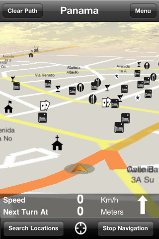
Panama GPS Map is a navigation App for the country of Panama. All application features and map data is stored within your iPhone, allowing you to use the app freely without the worry of expensive data charges. Fast, simple user interface with detailed map data allows you to navigate throughout Panama using your iPhone.
· Navigation from current position to destination
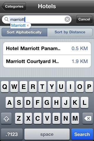
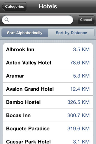
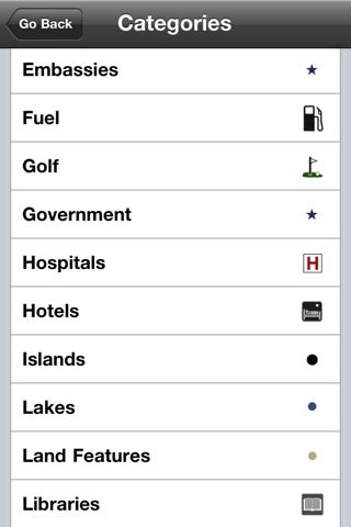
· Thousands of searchable businesses and Points of Interest
· Fastest and shortest route calculation
· Automatic route recalculation
· Custom location saving and searching
· 2D and 3D navigation views
· Distance to next turn
· Turn arrow for easier navigation
· Current speed
· Smooth panning, pinch zoom, and increased detail with zoom
What's New in This Release:
· Added 28km of new roads
· Added 2,338 new POIs throughout Panama
· Improved navigation
What's New in 4.6.0:
· Point of Interest display on/off setting
· New user location arrow
· Bug fixes and memory improvements
What's New in 4.3.7:
· Points of Interest details displayed (Address, Phone, Website, Email, Etc.)
· Spanish language supported
· Improved tracking of location while driving
· Updated road labeling and map drawing
· Bug fixes and memory improvements
· Updated map data
What's New in 4.2.5:
· Updated map data and points-of-interest
· Improved tracking of location while driving
· Improved updating of route while driving
· Updated road labeling and map drawing
· Global point-of-interest search. Search for points-of-interest without having to enter a point-of-interest category first.
· Support for driving instructions in Metric and Imperial distance units
· Bug fixes and memory improvements
What's New in 4.1.24:
· Faster map drawing
· Support for backing up favorites via iCloud or iTunes
· Updated map data
What's New in 4.1.20:
· Backlight stays on while navigating
· Various bug fixes
· Performance and stability improvements
· Updated map data including roads, points of interest and other geographic details
· Automatic route recalculation
· Routing preference (Fastest vs Shortest) saved between runs of app
· Saved Recent POI Searches
· Full Screen iPad Compatibility
What's New in 4.0:
· Updated map rendering to improve stability and performance.
· Updated graphics and user interface for easier navigation.
· Updated map data including roads, points of interest and other geographic detail.
· Ability to navigate to both points of interest and roads
What's New in 3.0:
New, Updated and Improved App features:
· Updated and improved map navigation
Map Data Updates:
· Added POI's into Panama City, Colon, David, Santiago, Bocas del Toro, Pedasi.
· Added oneways into Panama City, Colon, Santiago and David.
· Improved navigation in Panama City.
· Added roads into Colon and Guayra.
· Fixed polygon around Isla Contadora and Isla Grande.
Like it? Share with your friends!
If you got an error while installing Themes, Software or Games, please, read FAQ.
Supported operating systems:
Apple iOS 10.x (iPad), Apple iOS 10.x (iPhone), Apple iOS 11.x (iPad), Apple iOS 12.x (iPad), Apple iOS 12.x (iPhone), Apple iOS 4.0.x (iPhone), Apple iOS 4.0.x (iPod Touch), Apple iOS 4.2.x (iPad), Apple iOS 4.2.x (iPhone), Apple iOS 4.2.x (iPod Touch), Apple iOS 4.3.x (iPad), Apple iOS 4.3.x (iPhone), Apple iOS 4.3.x (iPod Touch), Apple iOS 5.0 (iPad), Apple iOS 5.0 (iPhone), Apple iOS 5.0 (iPod Touch), Apple iOS 6.0 (iPad), Apple iOS 6.0 (iPhone), Apple iOS 6.0 (iPod Touch), Apple iOS 7.0 (iPad), Apple iOS 7.0 (iPhone), Apple iOS 7.0 (iPod Touch), Apple iOS 8.x (iPad), Apple iOS 8.x (iPhone), Apple iOS 8.x (iPod Touch), Apple iOS 9.x (iPad), Apple iOS 9.x (iPhone), Apple iOS 9.x (iPod Touch), Apple iPhone OS 3.1.x, Apple iPhone OS 3.1.x (iPod Touch), Apple iPhone OS 3.2.x (iPad)
Similar Software:
Angelina National Forest - GPS Map Navigator Angelina National Forest - GPS Map Navigator - FlytoMap provides complete, quick and easy to use map applications for navigation for iPhone. Continues in the tradition of offering depth of information and functionality across expected places all over the world, exploring the map you get maximum details obtaining detailed information of every object on the map
EEU Region - iGO primo app EEU Region - iGO primo app - iGO primo app turns your iOS device into a powerful navigation system. Using the same experienced iGO Engine employed by GPS navigation devices all over the world, the app can reliably guide you to your destination in no time.
The software uses accurate offline maps which can be used anywhere
Barbados GPS Map Barbados GPS Map is a navigation App for the country of Barbados. All application features and map data is stored within your iPhone, allowing you to use the app freely without the worry of expensive data charges. Fast, simple user interface with detailed map data allows you to navigate throughout Barbados using your iPhone
Boise City Map Offline Boise City Map Offline - This will be perfect when you are traveling and you don't have internet connection. This Offline Maps is not a replacement of Google Maps. It is used when you don't have internet connection and want to use maps
Garajonay National Park - GPS Map Navigator Garajonay National Park - GPS Map Navigator - FlytoMap provides complete, quick and easy to use map applications for navigation for iPhone. Continues in the tradition of offering depth of information and functionality across expected places all over the world, exploring the map you get maximum details obtaining detailed information of every object on the map
Luxembourg City Map Offline Luxembourg City Map Offline - This will be perfect when you are traveling and you don't have internet connection. This Offline Maps is not a replacement of Google Maps. It is used when you don't have internet connection and want to use maps
Nav4D Arkansas Nav4D Arkansas - Single intuitive menu gives the user all the information needed to begin a journey with confidence. Along the way take advantage of the automatic local and global search with rich contents.
Designed to attract everyone, the new interface concept makes usability and design a key point. Nav4D is the perfect navigation system for iPhone
Grand Teton National Park - GPS Map Navigator Grand Teton National Park - GPS Map Navigator - Continues in the tradition of offering depth of information and functionality across expected places all over the world, exploring the map you get maximum details obtaining detailed information of each object on the map
Bengaluru (India) Map Offline Bengaluru (India) Map Offline - This will be perfect when you are traveling and you don't have internet connection. This Offline Maps is not a replacement of Google Maps. It is used when you don't have internet connection and want to use maps
Navmii GPS Germany HD Navmii GPS Germany HD - Navmii is a powerful GPS navigation solution for iOS devices. The app features turn-by-turn directions, voice guidance, automatic rerouting, live Google and Microsoft Bing Search, and more.
Navmii uses offline maps which are stored locally on the device, so there is no need for a data connection
Other Software by developer «Kaart Data LLC»:
Costa Rica GPS Map Costa Rica GPS Map is a navigation App for the country of Costa Rica. All application features and map data is stored within your iPhone, allowing you to use the app freely without the worry of expensive data charges. Fast, simple user interface with detailed map data allows you to navigate throughout Costa Rica using your iPhone
Barbados GPS Map Barbados GPS Map is a navigation App for the country of Barbados. All application features and map data is stored within your iPhone, allowing you to use the app freely without the worry of expensive data charges. Fast, simple user interface with detailed map data allows you to navigate throughout Barbados using your iPhone
Guatemala GPS Map Guatemala GPS Map is a navigation App for the country of Guatemala. All application features and map data is stored within your iPhone, allowing you to use the app freely without the worry of expensive data charges. Fast, simple user interface with detailed map data allows you to navigate throughout Guatemala using your iPhone

")


 Map Offline")


